
Glowe
| coat of arms | Germany map | |
|---|---|---|

|
Coordinates: 54 ° 34 ' N , 13 ° 28' E |
|
| Basic data | ||
| State : | Mecklenburg-Western Pomerania | |
| County : | Western Pomerania-Ruegen | |
| Office : | North Ruegen | |
| Height : | 4 m above sea level NHN | |
| Area : | 22.2 km 2 | |
| Residents: | 972 (Dec. 31, 2019) | |
| Population density : | 44 inhabitants per km 2 | |
| Postal code : | 18551 | |
| Area code : | 038302 | |
| License plate : | VR, GMN, NVP, RDG, RÜG | |
| Community key : | 13 0 73 030 | |
| LOCODE : | DE GL2 | |
| Office administration address: | Ernst-Thälmann-Str. 37 18551 Sagard |
|
| Website : | ||
| Mayor : | Thomas Mielke | |
| Location of the community Glowe in the district of Vorpommern-Rügen | ||
  |
||

Glowe is a municipality on the island of Rügen in the district of Vorpommern-Rügen in Mecklenburg-Western Pomerania (Germany). The municipality is administered by the North Rügen Office with its seat in the municipality of Sagard .
geography
Glowe is about 18 km north of Bergen on Rügen and is located at the western transition from the Jasmund peninsula to the Schaabe isthmus between the Baltic Sea ( Tromper Wiek ) and the Great Jasmunder Bodden . The road from Sagard to Altenkirchen runs through the municipality of Glowe.
Community structure
The districts of Glowe belong to:
The municipality also includes the Koosdorf district , where there used to be a single farm .
history

Glowe was first mentioned in a document around 1314. The name Glowe comes from the Slavic Gluowa or Glova and means something like head, named after the 9 m high king's horn , a small cape. The community then came into being around or on the Königshörn. The area was part of the Principality of Rügen until 1325 and then the Duchy of Pomerania . With the Peace of Westphalia of 1648, Rügen and thus also the area of Glowe became part of Swedish Pomerania .
To the east of the place ran the Swedish bar field work and the 2nd field work line Glowe. Several wars, from the thirty to the Nordic and the Napoleonic invasion, as well as several disputes between Brandenburg / Prussia and Sweden (1675–1679, 1759 etc.) have shaped the defense landscape of Rügen. Since they were only built as ramparts, reinforced with fascines , they slowly fell into disrepair due to erosion and overbuilding and are no longer readily visible today. The lines were reinforced by small individual hills. The Swedes used the undulating terrain at the narrow point between the Baltic Sea and Lake Spycker.
In 1815, Rügen came to the Prussian province of Pomerania as part of New Western Pomerania . Since 1818 the area belonged to the district of Rügen .
_4.JPG)
The former fishing village then grew more and more into the neighboring Schaabewald at the beginning of the spa tourism at the beginning of the 20th century .
From 1939 Glowe belonged to the municipality of Bobbin (Rügen), but got its independence back after the Second World War.
From 1952 to 1955 it belonged to the Bergen district . The community then belonged to the Rügen district in the Rostock district until 1990 and became part of the state of Mecklenburg-Western Pomerania in the same year. The district of Rügen, which was again designated as this from 1990, was merged in 2011 in the district of Vorpommern-Rügen.
In GDR times, the main station and administration of Rügen radio , the radio transmission system for the DSR merchant fleet and the fishing fleet was located in Glowe . Camping Glowe existed from 1965 to 1993. The nationally owned combine Buna built and maintained a children's holiday camp for the children of its employees. Another children's holiday camp existed on the eastern outskirts as that of the FDGB - the individual union for teaching and education - today one of the preferred single-family home locations in the village. Finally, a third large holiday camp was run by the BMK Coal and Energy . This was located in the center of the village. It was demolished in the mid-1990s and the area was later built on with homes and a net supermarket. The new center of Glowe is to be built here. Glowe is a state-approved resort .
Bobbin was first mentioned in 1250. At Bobbin there was a temple in Slavic times until around 1168. The Gothic St. Pauli field stone church dates from around 1400.
Ruschvitz: The small manor house dates from around 1800.
Spyker was first mentioned in 1318. It belonged to the von Külpen families and from after 1344 to 1648 von Jasmund , from 1649 to 1687 to the Swedish imperial marshal Carl Gustav Wrangel and heirs, then to the Brahe families until 1817 and Fürst zu Putbus until 1945 . The castle dates from the 16th century. It's been a hotel since 1990. → See also: Spycker Castle
politics
coat of arms
Blazon : “Divided by a five-pinned, silver-edged red bar; above in green a floating silver rafter covered with a golden crown on the gable and below in blue a six-spoke golden ship's steering wheel. "
Attractions

Harbor in Glowe
Glowe: Restaurant Ostseeperle


- Spyker Castle , which was once the Swedish field marshal and Governor-General of Swedish Pomerania , Carl Gustaf Wrangel belonged,
- Gothic stone church St. Pauli in Bobbin from the 14th century
- St. Birgitta Glowe Chapel
- Polchow fishing village with harbor
- Lake promenade with harbor in Glowe
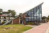
- The Ostseeperle in Glowe, pre- stressed concrete building (1968) by Ulrich Müther as a tipped hypar shell with a large window front to the Baltic Sea (refurbished 2005–2009, reopened as a restaurant in 2009)
- Spyckerscher See
- The rescue boat Kurt Hoffmann of the German Society for the Rescue of Shipwrecked People is stationed in Glowe.
Personalities
- Gödeke Michels († 1401), pirate and one of the leaders of the Vitalienbrüder
Web links
Individual evidence
- ↑ Statistisches Amt MV - population status of the districts, offices and municipalities 2019 (XLS file) (official population figures in the update of the 2011 census) ( help ).
- ↑ Geodata viewer of the Office for Geoinformation, Surveying and Cadastre of Mecklenburg-Western Pomerania ( information )

Ahrenshagen-Daskow | Ahrenshoop | Altefähr | Altenkirchen | Altenpleen | Baabe | Bad Sülze | Barth | Mountains on Rügen | Binz | Born a. Darß | Breege | Buschvitz | Dettmannsdorf | Deyelsdorf | Dierhagen | Divitz-Spoldershagen | Dranske | Drechow | Dreschvitz | Eixen | Elmenhorst | Franzburg | Fuhlendorf | Garz / Rügen | Went | Glewitz | Glowe | Goehren | Grammendorf | Gransgebieth | Gremersdorf-Buchholz | Grim | Groß Kordshagen | Gross Mohrdorf | Gustow | Hugoldsdorf | Hiddensee Island | Jakobsdorf | Karnin | Kenz-Küstrow | Klausdorf | Kluis | Kramerhof | Lancken-Granitz | Lietzow | Lime wood | Löbnitz | Lohme | Lüdershagen | Lüssow | Marlow | Millienhagen-Oebelitz | Mönchgut | Neuenkirchen | Niepars | Pantelitz | Papenhagen | Parchtitz | Patzig | Poseritz | Preetz | Prerow | Prohn | Pruchten | Putbus | Putgarten | Ralswiek | Rambin | Rappin | Ribnitz-Damgarten | Richtenberg | Hall | Sagard | Velvet | Sassnitz | Schaprode | Schlemmin | Sehlen | Sellin | Semlow | Splietsdorf | Steinhagen | Stralsund | Süderholz | Sundhagen | Trent | Tribsees | Trinwillershagen | Ummanz | Velgast | Weitenhagen | Wendisch Baggendorf | Wendorf | Wieck a. Darß | Wiek | Wittenhagen | Wustrow | Zarrendorf | Zingst | Zirkow