
Klausdorf (near Stralsund)
| coat of arms | Germany map | |
|---|---|---|

|
Coordinates: 54 ° 24 ' N , 13 ° 1' E |
|
| Basic data | ||
| State : | Mecklenburg-Western Pomerania | |
| County : | Western Pomerania-Ruegen | |
| Office : | Altenpleen | |
| Height : | 3 m above sea level NHN | |
| Area : | 11.78 km 2 | |
| Residents: | 661 (Dec. 31, 2019) | |
| Population density : | 56 inhabitants per km 2 | |
| Postal code : | 18445 | |
| Area code : | 038323 | |
| License plate : | VR, GMN, NVP, RDG, RÜG | |
| Community key : | 13 0 73 044 | |
| Office administration address: | Parkstrasse 2 18445 Altenpleen |
|
| Website : | ||
| Mayor : | Thomas Reichenbach | |
| Location of the municipality of Klausdorf in the district of Vorpommern-Rügen | ||
  |
||

Klausdorf is a municipality north-west of Stralsund in the district of Vorpommern-Rügen . The municipality is administered by the Altenpleen office based in the Altenpleen municipality. Klausdorf has been a recognized resort since February 5, 2018 .
.JPG)
Geography and traffic
Klausdorf is located about 15 kilometers northwest of Stralsund and is the northernmost and at the same time the smallest municipality in the Altenpleen district. The municipality lies between the Grabow and the Prohner Wiek , in the northernmost corner of the mainland in Mecklenburg-Western Pomerania. The northern part of the municipality is part of the Vorpommersche Boddenlandschaft National Park . The hilly terrain culminates at Barhöft at 33.3 m above sea level. NHN . Here is also the only larger forest area, the otherwise agriculturally dominated landscape.
- Landscapes and districts
- Barhöft
- Klausdorf
- Solkendorf
- Zarrenzin
history
Klausdorf was first mentioned in 1280, Zarrenzin in 1296 and Barhöft only in 1792.
After belonging to the Principality of Rügen , the area fell to the Duchy of Pomerania in 1326 .
After the Thirty Years' War until 1815 it belonged to Swedish Pomerania and then to the Prussian province of Pomerania .
The community was part of the Franzburg-Barth district until 1952 and then belonged to the Stralsund district in the Rostock district until 1994 .
Coat of arms, flag, official seal
The municipality has no officially approved national emblem, neither a coat of arms nor a flag . The official seal is the small state seal with the coat of arms of the region of Western Pomerania . It shows an upright griffin with a raised tail and the inscription "GEMEINDE KLAUSDORF * LANDKREIS VORPOMMERN-RÜGEN".
Attractions
→ See also: List of architectural monuments in Klausdorf (near Stralsund)
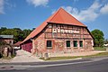
- Inspector's house of the Klausdorf estate from 1890. The neo-baroque manor house around 1900 was replaced in the 1960s by a prefabricated building, the “farmer's house”. The former orangery, a building from the 19th century, has been renovated in recent years. In 1389 Berthold von Rethem is named as the owner of Gut Klausdorf, in 1495 Edgar Garlepow and in 1520 the Stralsund councilors Heinrich Sonnenberg and Jürgen Buchow. His great-granddaughter Barbara, widow of Johann Hagemeister, was the owner of the Klausdorf farm in 1695. The so-called Rampenhof, another property in Klausdorf, belonged to the St. Annen und Brigitten monastery in Stralsund in 1628 . After Barbara Hagemeister also acquired this in 1701, Klausdorf was owned by the Hagemeister family until it was expropriated in 1945, the rare example of a bourgeois estate that had been inherited since the Renaissance period (1520).
- Klausdorf crane exhibition
- Barhöft harbor
- Information exhibition of the national park in Barhöft

Vorpommersche Boddenlandschaft National Park near Barhöft
Vorpommernhaus


Web links
Individual evidence
- ↑ Statistisches Amt MV - population status of the districts, offices and municipalities 2019 (XLS file) (official population figures in the update of the 2011 census) ( help ).
- ↑ Klausdorf near Stralsund is now a recognized resort. Süddeutsche Zeitung , February 5, 2018, accessed on August 7, 2020 .
- ^ Main statute of the municipality of Klausdorf . July 15, 2014 ( altenpleen.de [PDF; 38 kB ; accessed on September 19, 2017]).
- ↑ Main Statute, Section 2, Section 1 (PDF).

Ahrenshagen-Daskow | Ahrenshoop | Altefähr | Altenkirchen | Altenpleen | Baabe | Bad Sülze | Barth | Mountains on Rügen | Binz | Born a. Darß | Breege | Buschvitz | Dettmannsdorf | Deyelsdorf | Dierhagen | Divitz-Spoldershagen | Dranske | Drechow | Dreschvitz | Eixen | Elmenhorst | Franzburg | Fuhlendorf | Garz / Rügen | Went | Glewitz | Glowe | Goehren | Grammendorf | Gransgebieth | Gremersdorf-Buchholz | Grim | Groß Kordshagen | Gross Mohrdorf | Gustow | Hugoldsdorf | Hiddensee Island | Jakobsdorf | Karnin | Kenz-Küstrow | Klausdorf | Kluis | Kramerhof | Lancken-Granitz | Lietzow | Lime wood | Löbnitz | Lohme | Lüdershagen | Lüssow | Marlow | Millienhagen-Oebelitz | Mönchgut | Neuenkirchen | Niepars | Pantelitz | Papenhagen | Parchtitz | Patzig | Poseritz | Preetz | Prerow | Prohn | Pruchten | Putbus | Putgarten | Ralswiek | Rambin | Rappin | Ribnitz-Damgarten | Richtenberg | Hall | Sagard | Velvet | Sassnitz | Schaprode | Schlemmin | Sehlen | Sellin | Semlow | Splietsdorf | Steinhagen | Stralsund | Süderholz | Sundhagen | Trent | Tribsees | Trinwillershagen | Ummanz | Velgast | Weitenhagen | Wendisch Baggendorf | Wendorf | Wieck a. Darß | Wiek | Wittenhagen | Wustrow | Zarrendorf | Zingst | Zirkow