Quitzin
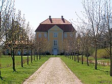
Quitzin is a district of the municipality of Splietsdorf in the Vorpommern-Rügen district . The place is in the valley of the Trebel , seven kilometers northwest of Grimmen . The Quitzin Hunting Lodge is an important cultural monument in Western Pomerania .
history
- Surname
The place name is derived from the old Kučin , derived from the surname Kuča . In documents the spellings curiam can be found in Quitsin (1320-23), Quissin (1618) and Quitzin (since 1631).
- Early settlement
Historical finds show that the area was settled early on. These include settlement ceramics (wall fragments and edges) as well as iron slag from the Roman Imperial Era and the Migration Period and, in some cases, belted Yavian ceramics from the Slav period . From the period of the Middle Ages and the modern era , a lime kiln desert , a mill desert and a former brickworks were determined by evaluating Prussian original measuring table sheets .
An early settlement is also indicated by the ramparts of a ring castle in the immediate vicinity of today's castle, which was built in the 13th century and was surrounded by a moat, and also the Slavic name Quitzin.
Well and hunting lodge
The mansion is a three-storey, five or three-axis, block-like plastered building with a courtyard-side central projection with a triangular gable decorated with a coat of arms. The two single-storey side wings date from the same time. All buildings have high mansard roofs .
The property is located in a large landscaped park that was originally laid out as a baroque garden and merges into the Trebel lowland.
history
The manor house was first mentioned around 1457. It was built in 1607 in the brick renaissance style on the vault of a 13th century castle. Around 1723 it was rebuilt and reshaped into a hunting lodge in the Baroque style. In 1908 the estate came to Werner von Veltheim . The family was expropriated in 1937 and until 1945 was there a military training camp of the SS . The estate was relocated from 1945. The manor was initially a refugee camp. From 1971 to 1990 the civil defense of the GDR used the building partly as a warehouse. The building fell into disrepair and lost many design elements due to renovations. The Rübcke von Veltheim family bought the building after 1990 and had it renovated.
Castle chapel
In the manor complex is the small castle chapel, a plastered brick building built in 1614, the core of which could be an earlier date. During the restoration after 1990, the exterior of the chapel was given a shell limestone plaster.
Inside: sandstone altarpiece from 1616, pulpit with Renaissance carvings, crucifix from the 14th century, lectern from 1714, octagonal baptismal font from the second half of the 19th century.
The churchyard is surrounded by a stone wall. On it is a grave stele from 1746.
The former palace chapel is occasionally still used by the church, for example for weddings and baptismal services.
literature
- Selge, Frank: The trial of the Teutonic Order for the New West Pomerania estate of Count Erasmus Ernst Friedrich Graf and Herr zu Küssow and Megow in the years 1824 to 1841. In: Lectures on Mecklenburg family research, Issue 10, 2001, pp. 47-64
Web links
- Quitzin Hunting Lodge
- Castle Church in German, English, Swedish and Polish ( Memento from September 27, 2007 in the Internet Archive )
Individual evidence
- ^ Manfred Niemeyer: Greifswald contributions to toponymy VII. District of Northern Pomerania. Druckhaus Panzig, Greifswald 2007, ISBN 3-86006-266-2 , p. 109
- ↑ State Office for Land Monument Preservation Mecklenburg-Western Pomerania and Archaeological State Museum (ed.): Bodendenkmalpflege in Mecklenburg-Western Pomerania. Yearbook 2001. Volume 49. , Lübstorf 2002, ISSN 0947-3998
- ^ Georg Dehio : Handbook of German Art Monuments. Mecklenburg-Western Pomerania , Deutscher Kunstverlag, revision, Munich / Berlin 2000, ISBN 3-422-03081-6 , p. 429
- ↑ Jana Olschewski: Open Churches I. From the Recknitz to the Strelasund. Helms-Verlag, Schwerin 2005, ISBN 3-935749-49-X , p. 30
Coordinates: 54 ° 7 ' N , 12 ° 58' E


