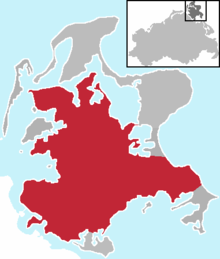
Motherland
The motherland is the central part of the island of Rügen, with the largest area of around 650 km² . It is bounded in the south by the Strelasund and the Greifswalder Bodden . In the northeast, the Jasmund peninsula connects over the Schmale Heide , in the southeast the Mönchgut and the Zudar peninsula in the south. In the west, the Muttland borders on the West Rügen Bodden and in the north on the North Rügen Bodden . Characteristic of the Muttland is the flat to flat undulating ground moraine landscape , which still bears the character of the northeast Mecklenburg flatland. The area is subdivided to a certain extent through numerous depressions and valleys with no drainage, as well as some smaller streams. The moraine landscape flattens out to the north and barely reaches 20 meters up to the ridge in front of the Great Jasmunder Bodden . The transition to the surrounding bay coasts is mostly fluid. The motherland is shaped by large arable land, which is only occasionally broken up by tree and hedge structures. In between there are numerous pools and some small lakes, such as the Kniepower See and the Nonnensee . Only a few hills and ridges, which are covered with deciduous and mixed forest, tower over the flat plain. The highest points include the Rugard (118 m above sea level) near Bergen , the 107 m above sea level. NN high Tempelberg in the Granitz , the Hoch Hilgor (44 m) near Neuenkirchen and the Banzelvitzer Berge (45 m) near Rappin , which belong to a compression moraine towering in the north .
The predominant type of use, which takes up almost the entire area, is arable farming. Grassland use is only to be found to a very small extent. Some larger areas in the south, which are designated as resting areas for migratory birds of national and international importance, are of nature conservation importance. Larger cities are Bergen on Rügen , Garz and Putbus .
Web links
Coordinates: 54 ° 24 ' N , 13 ° 21' E

