
Rugard


The Rugard is a 91 m above sea level. NN high elevation in the core area of the Baltic island of Rügen . The compression moraine formed in the last Ice Age is located on the northeastern outskirts of Bergen on Rügen . Probably from the 9th century to 1325 AD there was a castle here, in which the Ranen princes resided, who owned Rügen and parts of the adjacent mainland. The name Rugard (Slavic: Rujanenburg ) comes from that time. The complex consisted of a main castle and an outer bailey and covered an area of 2.3 hectares. The complex is well preserved as an earthwork relict, but difficult to recognize because of the vegetation.
After the ranic dynasty in 1325 with Wizlaw III. became extinct, the castle lost its importance and fell into disrepair; some of the ramparts have been preserved to this day. In the Middle Ages there was a mill here and the area was used for agriculture. Until 1830, when Prince Wilhelm Malte I (1783-1854) of Putbus had the castle wall reforested, the Rugard was not forested. Karl Friedrich Schinkel captured this sight in his painting “The Rugard on Rügen” in 1821 .
In the course of time, a forest area emerged, which mainly consists of spruce and pine , interrupted by small oak , birch and poplar stands as well as many other deciduous and coniferous trees. The native European beech is hardly represented. Since 1984, a 2.5 km long nature trail has been leading through the Rugard forest as a circular route, on which interested visitors can use display boards to find out about the diverse flora and fauna in this historic landscape.
From the Ernst Moritz Arndt Tower built on the Rugard , you have a view of the entire island. This tower was Ernst Moritz Arndt , who was born in Great Schoritz Pomerania, one in the 1870s monument set. The foundation stone was laid on December 26, 1869, the poet's 100th birthday. The decision was made in favor of the design by the Berlin architect and master builder Hermann Eggert and construction began in autumn 1872, which could not be completed until 1877 due to lack of funds. In the 1930s, the Rugard forest area had reached a height that no longer permitted an unobstructed panoramic view from the top gallery of the tower. Between 1935 and 1937 a National Socialist Thingplatz was built here, which was mainly used by the Hitler Youth .
During the fundamental renovation of the tower, which was carried out from 2000 to 2002, it was therefore decided to replace the wooden dome from 1955 with a dome made of glass and steel (while maintaining the historical shape) and thus create a higher viewing level.
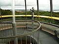
Viewing platform of the Ernst Moritz Arndt Tower

Ranen castle wall on the Rugard (sketch around 1890)

Historic postcard by Brück & Sohn , 1900


-Br%C3%BCck_%26_Sohn_Kunstverlag.jpg)
Web links
- Literature about Rugard in the Landesbibliographie MV
- Illustration by Heinrich Wilhelm Teichgräber from 1838: View from Rugard on Rügen to Jasmund ( digitized version )
Coordinates: 54 ° 25 ′ 4 ″ N , 13 ° 26 ′ 48 ″ E