Fischland
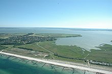
The Fischland is a land bridge on the southern Baltic coast of the Mecklenburg Bay and part of the Fischland-Darß-Zingst peninsula . It belongs to the state of Mecklenburg , the Darß already belongs to Western Pomerania . The border runs along the Grenzweg in Ahrenshoop .
geography
Fischland is the westernmost element of the Bodden compensation coast of Mecklenburg-Western Pomerania. As a former island, it was bounded by two sea spars that were navigable until the 14th century : the Permin in the south and the Loop in the north. The loop or its former position also marks the border between Mecklenburg and Western Pomerania . In more recent times, however, the Ribnitz town meadows south of Wustrow have also been added to the Fischland and mostly Dierhagen and the northern edge of the Ribnitz Forest are taken as the southern border. This area is also called Niederes Fischland . In the north-west and south-east the borders are the active cliff ( Hohes Ufer ) and the flat beach on the Baltic Sea or the shoreline of the Saaler Bodden . The Fischland, which runs from southwest to northeast, is thus 5 km to 8.5 km long (depending on the borderline) and between 400 m and 2.5 km wide.
At 17.9 m above sea level, the highest point on Fischland is the Bakelberg near the steep bank of Althagen / Niehagen .
There are only four villages in total on the Fischland, which today mostly merge into one another: the Ahrenshooper districts of Althagen and Niehagen as well as the municipality of Wustrow with the district of Barnstorf. The old, northern part of the village of Ahrenshoop, which is known as the holiday and residence of artists, is no longer on the Fischland, but already on the Vordarß and thus on (pre) Pomeranian territory.
From the island to the land bridge
The Pleistocene core of Fischland ("Hohes Fischland"), which also corresponds to the historical island, consists of meltwater sands and boulder clay from the Vistula glacial . In the course of the younger Holocene (from approx. 5000 BC) it and the coastal area surrounding it were subject to strong changes due to currents, waves and wind ( coastal compensation ). This created one hand by erosion of the cliffs on the Baltic side and on the other hand grew by landing the land north and south of "Ur-Fish Land", land links so that gradually the Darß and out were to the mainland.
In 1392 or 1393, 1,000 men from the Hanseatic city of Rostock, whose patricians saw their trading privileges threatened by a seaport on the Darß , including their beneficiaries from the activities of the Vitalienbrüder , destroyed the port of Ahrenshoop and "damned" the loop. Around 1400 the Stralsunders sank three ships in the Permin and closed it. At least the loop ("Darßer Canal") probably remained permanently open until the second half of the 15th century. Violent storm floods tore the isthmus open again and again afterwards, the loop verifiably in 1625 1761 and 1872, the Permin in 1786 and most recently in 1872 and 1875.
Even today, storms carry an average of half a meter from the Baltic coast of Fischland each year in order to deposit it further north at Darßer Ort .
literature
- cards
- Fischland, Darß, Zingst (double card ), 1: 30,000, green heart , Ilmenau / Ostseebad Wustrow. ISBN 978-3-929993-33-2
- Travel guides and illustrated books
- Roland Buchwald: Fischland, Darß and Zingst. Landscape and travel guide for hikers, water sports enthusiasts, cyclists and motorists . green heart , Ilmenau / Ostseebad Wustrow. ISBN 3-929993-52-X
- Frank Thamm: Darß, Fischland and Zingst . Ellert and Richter, Hamburg. ISBN 3-89234-815-4
- Horst Prignitz, Thomas Grundner: Fischland, Darß, Zingst . Carl Hinstorff, Rostock. ISBN 3-356-01056-5
- Fiction
- Käthe Miethe : The Fischland , 1949
- Käthe Miethe: Bark Magdalene , 1951
- Rudolf van Nahl: Fischland legend. Found and invented things from Fischland on the Baltic Sea (Coastal Kieker 1), Bülten Verlag, Kückenshagen 2006. ISBN 3-938510-22-6
Web links
- Fischland-Darß-Zingst. Official website.
Individual evidence
- ↑ from 1835 at the latest according to the Prussian original measurement table (PUM)
- ↑ a b c Wolfgang Janke, Reinhard lamp: Fischland-Darß-Zingst. P. 219–230 in: Ralf-Otto Niedermeyer et al .: The German Baltic Sea Coast. Collection of geological guides, Volume 105. 2nd completely revised edition. Borntraeger, Stuttgart 2011, ISBN 978-3-443-15091-4 , p. 224 f.
- ↑ M. Naumann: Holocene coastal development in the Darss-Zingst-Hiddensee area and the interaction of eustasia, neotectonics and sediment supply. Inaugural dissertation to obtain the academic degree of doctor rerum naturalium (Dr. rer. Nat.) At the Faculty of Mathematics and Natural Sciences at the Ernst-Moritz-Arndt University of Greifswald. 2012, online .
- ^ Friedrich Wilhelm Barthold: History of Rügen and Pomerania. Third part: From the death of Barnim I (1278) to the appearance of the Hohenzollern in the Mark Brandenburg (1411). Friedrich Perthes, Hamburg 1842, p. 539 f. (MDZ reader, Bavarian State Library)
- ↑ a b Martin Bütow, Reinhard Lampe: Excursion 7: Greifswald - Stralsund - Ribnitz-Damgarten - Fischland - Darß - Prerow - Zingst - Barth - Stralsund - Greifswald. S. 114–123 in: Wolfgang Albrecht (Ed.): Excursion Guide Mecklenburg-Western Pomerania. Ten geographical excursions through typical landscapes of a new federal state. Höller and Zwick, Braunschweig 1991, ISBN 3-89057-013-5 , p. 115
- ^ Pomerania in four map sheets, published by the Kgl. Prussian Academy of Sciences, drawn by Andreas August Rhode, 1761–1764
- ^ Wiebeking's map of Mecklenburg around 1786. Drawn by Carl Friedrich Wiebeking on the basis of the land maps of the Mecklenburg directorial survey of 1765/80, scale 1: 24,000
Coordinates: 54 ° 20 ' N , 12 ° 23' E


