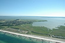
Permin
The Permin is a bay of the Saaler Bodden south of Wustrow . Originally, the Permin was a sea channel between the Saaler Bodden and the Baltic Sea . At the same time it delimited the Fischland in the south.
Since the Permin was navigable in the 13th and 14th centuries at average water depths of 2 to 3 meters, it formed an important waterway for the trade of the cities of Ribnitz and Barth . The passability was often impaired by storms and silting . Although the Permin was only navigable for smaller ships and was mainly used by the local population with small, open boats for trading trips, the Hanseatic League saw its trading privileges impaired. At the end of the 14th century, trade in the Baltic Sea was also significantly disrupted by the Vitalienbrüder , who were temporarily held by the Mecklenburg dukes and the Pomeranian duke Barnim VI. were supported. The Vitalienbrüder used the Permin and the Loop at Ahrenshoop to travel into the Bodden waters , which they used as a retreat and hiding place between their pirate trips. In 1392 or 1393 the Hanseatic city of Rostock destroyed the port of Ahrenshoop and "dammed" the loop. The Hanseatic city of Stralsund had three ships sunk in the Permin in 1400, which accelerated the silting up of the passage and ended navigability. This closed both connections between the lagoon and the lake towards the end of the 14th and beginning of the 15th century. It is not known whether it was subsequently reopened.
It was not until 1625 that the loop was torn wide and deep by the storm flood, nothing is learned about the Permin, but it can be assumed that this even weaker stretch of coast was also significantly affected.
On a map by the Prussian military cartographer Andreas August Rhode in 1761 the Permin is shown as completely closed (see map at Loop ). In the map by Carl Friedrich von Wiebeking from 1786, the Permin is shown as open, but the representation is more similar to that of water compensation ditches than that of shipping lanes. That is why the map from 1761 may have omitted this detail. In 1835 the two arms of the map from 1786 are drawn as "old" (below) and "new" (above) harbor, but not as continuous to the Baltic coast.
During the flood of the Baltic Sea in 1872 , a creek 15 meters wide and 5 meters deep arose in the Permin area . An emergency bridge had to be built for the connection to the mainland. The subsequent storm flood of 1874 will have intensified this effect. As early as 1880, a compact dyke construction with a fore-dune can be seen in the measurement table ; north of the old Permin, groyne fields were first cut. Before 1920, according to the measurement table sheet, an elevated road embankment was built parallel to the dune and the dike between Wustrow and the southern mainland. This also sealed off the former Permin, and the “new harbor” was also filled in. During the GDR era, the dike on the bottom side was then built to prevent flooding from behind.
Even today, this stretch of coast is classified as severely endangered during floods, which is why reinforcing coastal protection measures are planned there.
literature
- Friedrich Wilhelm Barthold: History of Rügen and Pomerania: From the death of Barnim I (1278) to the appearance of the Hohenzollern in the Mark Brandenburg (1411) , Volume 3, Perthes 1842. Limited preview in the Google book search
- Bütow / Lampe: Greifswald geographers . In: Excursion Guide Mecklenburg-Western Pomerania . Section 7, Höller and Zwick, Braunschweig 1991, ISBN 3-89057-013-5
Web links
- Manfred Hessel: “Sea ports” in Wustrow and Ahrenshoop. Retrieved December 16, 2014 .
Individual evidence
- ^ Friedrich Wilhelm Barthold : History of Pomerania and Rügen. 3rd part: From the death of Barnim I (1278) to the appearance of the Hohenzollern in the Mark Brandenburg (1411). Hamburg 1842, p. 539 ( Google Books )
- ↑ a b Bütow / Lampe, Greifswalder Geografen, p. 115.
- ^ A b General Plan Coastal and Flood Protection Mecklenburg-Western Pomerania. P. 17 , accessed December 16, 2014 . ( PDF ; 1.04MB)
Coordinates: 54 ° 20 ′ 23 ″ N , 12 ° 23 ′ 28 ″ E

