
Loop (inlet)


The Loop or Darß Canal was an arm of the sea between the Saaler Bodden and the Baltic Sea near Ahrenshoop . "Loop" means something like "run" in Low German (Low German) usage. It delimited the fish country in the north. Up until the end of the 14th century, the loop was the northern sea channel from the Bodden to the Baltic Sea, after which it was only in temporary phases after artificial and natural openings after storm floods.
geography
The former estuary ran between today's Ahrenshoop district of Althagen and Ahrenshoop. The loop had a draft of around two meters and had piles for securing the banks and mooring the boats and barges. The passability was often impaired by storms and silting. Today there is only a 135 m long ditch between the main road and the rest of the short Landwehr on the dirt road along the so-called Grenzweg. This trench follows the line of the loop, which at the same time formed the border between Mecklenburg and Pomerania and still forms today. To the south of the loop, the Fischland plateau begins with the sea-side cliff.
history
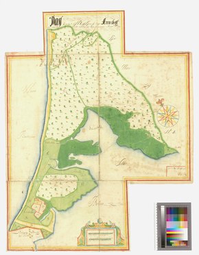
The Pomeranian Duke Wartislaw VI. (around 1345–1394) had Ahrenshoop secured north of the Loop in the second half of the 14th century by means of ditches, border fortifications, customs controls and a fortified hill . Whose brother Duke Bogislaw VI. (1350-1393) wanted to expand Ahrenshoop into a larger trading settlement in order to benefit from the increased volume of trade. In the drawing from 1813, the Poggen Pool can be seen as an indentation on the right; the Duke wanted to build a harbor there. The dukes were at odds with the Hanseatic cities of Rostock, Stralsund and Greifswald because of the Wulflam affair and were therefore looking for a port for their trade. In 1392 or 1393 1000 men from Rostock, whose patricians saw their trading privileges impaired by a seaport on the Darß , destroyed the port of Ahrenshoop and "damned" the loop. In 1400 the Stralsunders sank 3 ships in the Permin and closed it. Whether Loop and Permin afterwards by Wartislaw VI. Son of Barnim VI. (1365–1405) or the Mecklenburg town of Ribnitz could also be reopened, is not known. The Permin was not in the Pomeranian sphere of influence. Barnim VI. (Reign 1394–1403) was also a well-known opponent of the Hanseatic League , he was even a member of a Vitalienbruderschaft and actively participated in the raids. The Vitalienbrüder had also used the Loop and the Permin near Wustrow to travel into the Bodden waters , which they used as a retreat and hiding place between their raids until 1400 at the most. The later implementation of the expansion of the port and loop failed due to the loop's vulnerability to weather.
The cartographer and court astronomer at the Mecklenburg court Tilemann Stella (1525–1589) describes the loop: “Between the village of Oldenhagen (Althagen) and the Arnshope (Ahrenshoop) the Ribnitz water and lake went through to Saltze Mehr. Towards the beach a large heap of stone and tiles was found on the orth by the beach, there was a customs booth, so after the Saltze more 3 or 4 rods (about 50 meters). According to it, there are forty or fifty apples in the salt mound, at the end of the piles a large pile of stones, on which the bulwark stood. ” Since Stella describes in the past tense, the opening or the navigability cannot be derived or dated from it.
"The loop is said to have been open in 1455" (quote). After 1550, a closed coastline can be seen in contemporary maps, so the loop was closed. In 1625, the loop was "torn wide and deep" by a large storm flood (quote), which is also borne out by the fossil cliff on the street "Am Strom", which takes its name from this event.
In the Swedish survey of 1694 the loop was closed, the yellow signature directly in the course of the gatt suggests a recent filling up.
On a map by the Prussian military cartographer Andreas August Rhode, the loop is shown again or still open in 1761.
In the Prussian original measurement table sheet from 1835, the course of the closed loop can be clearly seen and the flushing or backfilling of the lake side up to the main road can also be seen. In the floodplain on the bottom side, the open course is still clear.
In the measuring table sheets from 1880 and 1920, the system of the beach dune and the construction of the dyke can already be seen , which began to intensify after the storm floods of 1872 and 1874 . The development also increased steadily. In the present, hardly anything can be seen of the course of the loop, except for the short ditch in the locality. Only a short Landwehr classified as a ground monument on the Grenzweg and the name of the latter also remind of the course. The trenches to the bay are straight and subsequently created as artificial drainage ditches in the moored alluvial land up to the dike and do not show the former course of the loop.
literature
- Friedrich Wilhelm Barthold : History of Rügen and Pomerania: From the death of Barnim I (1278) to the appearance of the Hohenzollern in the Mark Brandenburg (1411) , Volume 3, Perthes, Hamburg 1842. Full text
- Martin Bütow, Reinhard Lampe: Greifswald Geographers . In: Excursion Guide Mecklenburg-Western Pomerania . Section 7, Höller and Zwick, Braunschweig 1991, ISBN 3-89057-013-5
Individual evidence
- ↑ a b Barthold 3, p. 539 ( Google Books )
- ↑ a b Bütow / Lampe, Greifswalder Geografen, p. 115.
Web links
Coordinates: 54 ° 22 ′ 43 ″ N , 12 ° 25 ′ 9 ″ E