Uecker-Randow district
| coat of arms | Germany map |
|---|---|

|

Coordinates: 53 ° 34 ' N , 14 ° 4' E |
| Basic data (as of 2011) | |
| Existing period: | 1994-2011 |
| State : | Mecklenburg-Western Pomerania |
| Administrative headquarters : | Pasewalk |
| Area : | 1,635 km 2 |
| Residents: | 72,137 (Dec. 31, 2010) |
| Population density : | 44 inhabitants per km 2 |
| License plate : | UER |
| Circle key : | 13 0 62 |
| NUTS : | DE80I |
| Circle structure: | 54 parishes |
| Location of the district of Uecker-Randow in Mecklenburg-Western Pomerania | |
The district of Uecker-Randow was a district in the east of Mecklenburg-Western Pomerania , which existed from 1994 to 2011. Together with the district of Ostvorpommern and the Hanseatic City of Greifswald , it was integrated into the newly formed district of Vorpommern-Greifswald as part of the district reform in 2011 . The name of the district was derived from the largest bodies of water in the district, the rivers Uecker and its tributary Randow .
geography
Location and structure

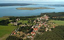
The district was located in the east of Mecklenburg-Western Pomerania. Poland bordered it in the east, Brandenburg in the south , the Mecklenburg-Strelitz district in the west, the Ostvorpommern district in the northwest and the Stettiner Haff in the northeast . On the border with the Republic of Poland , the coastline of the Szczecin Lagoon forms the bay of the Neuwarper See .
The northern half of the former district area is occupied by the Ueckermünder Heide , a wooded lowland plain. In the west, the district has a share in the Brohmer Berge terminal moraine . Here is also the 133 m above sea level. NN highest point (Ziegler Berg). The southern part of the district lies in a slightly hilly area east and west of the Randow and borders the landscape of the Uckermark in northern Brandenburg . The only middle center of the district was Pasewalk , whereby Ueckermünde fulfills middle center functions in parts. Sub-centers are Eggesin, Torgelow, Strasburg and Löcknitz. Rural central locations are Penkun and Ferdinandshof.
Landscaping
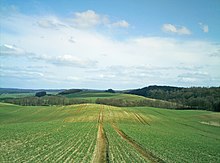
The flora and fauna in the district is rich in biotypes, some of which can be found in narrow spaces, but also widely scattered. In the south and south-west a large number of lakes, pools and moors are embedded in the soft, undulating loamy ground moraine plates. Due to the good soils, agriculture is primarily practiced in these areas and the proportion of forest is very low here. Along the Randow Valley you can find steppe flora that is unique in Germany and is mainly characterized by dry continental grass. The north of the district is mainly characterized by a high level of forest, which is also due to the poor soil properties. The alleys so typical of the landscape stretch along the lagoon coast as well as in many other parts of the district.
As a result of the decades of use of large parts of the Ueckermünder Heide as a military training area for the NVA and later also for the Bundeswehr, valuable dwarf shrub heaths and grasslands have developed in these areas . In the peripheral areas, nature reserves and retreat areas are z. B. originated for sea eagles.
The Friedland Great Meadow lies between the Ueckermünder Heide and the Brohmer Mountains . It was once the largest limestone moor in northern Germany. As a result of extensive amelioration in the 1960s, however, little is left of the former flora and fauna. The meadow areas are of particular importance today as resting and feeding grounds for almost 100 breeding bird species and another 80 guest bird species.
The Brohmer Mountains are characterized by extensive red beech and mixed forests. Many forest caves and bogs are embedded in the valleys and depressions of the hilly terminal moraine. They provide the habitat for black storks, lesser spotted eagles, cranes and also red deer. On the edge of the Brohmer Mountains is the Galenbeck lake with retreats for animal and plant species endangered in Central Europe.
The natural area has been protected by the Am Stettiner Haff Nature Park since 2005 .
Land use
| Surfaces | Percent (%) | Area (ha) |
|---|---|---|
| Settlements / traffic | 5.4 | 8770 |
| Agriculture | 50.9 | 82,672 |
| Forest | 31.8 | 51,650 |
| water | 10.3 | 19,328 |
Other areas (e.g. wasteland) are not included.
history
The district was created on June 12, 1994 from the former Pasewalk district (with the exception of the city of Brüssow , which was spun off to Brandenburg on July 18, 1992, and the communities of Nechlin, Wollschow, Woddow, Bagemühl, Grünberg), from over 90% of the former Ueckermünde district ( only the communities Neuendorf A and Wietstock came to the district of Ostvorpommern ) and from the eastern part of the former district of Strasburg (city of Strasburg and the communities of Blumenhagen , Groß Luckow and Klein Luckow ).
For an administrative reform in Mecklenburg-Western Pomerania and the creation of new great districts planned for 2009, the state government's considerations were to merge the district as a whole into a new "District of South Western Pomerania". After the judgment of the state constitutional court of July 26, 2007, the original reform law could not be implemented as it was incompatible with the state's constitution. In the course of a new district reform in 2011 , the district finally became part of the new district of Vorpommern-Greifswald with the district town of Greifswald.
Population development
The district lost around 20% of its population between 1990 and 2005. According to a population forecast by the state government, only 53,597 people will live in the district in 2020, which would be a decrease of 34.4% compared to 2002 and thus the largest population loss of all districts in Mecklenburg-Western Pomerania. The cause is a negative net migration and the associated high birth deficit.
In 2005 the proportion was:
- of under 25-year-olds approx. 23.5%
- of 25 to 50 year olds approx. 35.5%
- of those over 50 years of age approx. 41%.
|
|
politics
District administrators
- 1994–1997 Rainer Haedrich ( CDU )
- 1997-2004 Siegfried Wack (CDU)
- 2004–2011 Volker Böhning (non-party, Uecker-Randow civil alliance)
District council
The district assembly of the Uecker-Randow district consisted of 47 members. After the election on June 7, 2009, it was composed as follows until September 3, 2011:
| Political party | Seats |
|---|---|
| CDU | 15th |
| The left | 11 |
| SPD | 6th |
| BB UER | 4th |
| NPD | 4th |
| FDP | 3 |
| Bv-Rural Area | 2 |
| WIP | 1 |
| BfP | 1 |
The district (constituency number 62) consisted of 112 electoral districts with 63,742 eligible voters. 31,414 voters went to the polls, casting 3,574 invalid and 88,668 valid votes. This corresponds to a turnout of around 49.3% (all data from 2009).
More information on the electoral process and legal provisions : District Council (Mecklenburg-Western Pomerania)
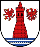
coat of arms
|
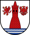
Blazon : “In silver one from a blue wave shield base, covered with two silver wave threads, protruding, tapered, tinned red brick round tower with a flattened pointed roof and two black arched windows side by side; accompanied: on the right by a golden armored red griffin, on the left by a golden armored red eagle. "
The coat of arms and the flag were designed by Lothar Herpich from Neubrandenburg . It was approved on June 6, 1995 by the Ministry of the Interior and registered under the number 83 of the coat of arms of the state of Mecklenburg-Western Pomerania. |
|
| Explanation of the coat of arms: In the coat of arms, on the one hand, the visual reference to the district town of Pasewalk is made with the tower as a symbol for the tower "Kiek in de Mark" . This building, which was once part of the city fortifications, was erected in 1445 and was named after the city's successful defense against Prince Elector Friedrich II of Brandenburg. On the other hand, the tower is intended to refer to the historical past of the territory and the architectural monuments to be preserved - such as the castle of the Pomeranian dukes in Ueckermünde, remnants of medieval city fortifications in Ueckermünde and Pasewalk, town and village churches of different style epochs. The griffin, the coat of arms of the Pomeranian dukes, and the eagle, the coat of arms of the margraves of Brandenburg, remind us that areas between Pomerania and Brandenburg were hotly contested in the Middle Ages. At the same time, the eagle is intended to indicate the centuries-old affiliation of the area around Strasburg to the Mark Brandenburg and thus take into account the feelings of home of the local population. The wave shield base stands for the Stettiner Haff, the wave threads for the rivers Uecker and Randow, which gave the district its name. In addition, the tinging of the base of the corrugated shield in blue and silver indicates that the predominant rural district belongs to the Western Pomerania region. |
flag
The flag was approved by the Ministry of the Interior on January 31, 2000.
The flag is striped lengthways with red, white, blue, white and red. The red stripes each take up a quarter, the white stripes each two ninths and the blue stripe takes up one eighteenth of the height of the flag cloth. In the middle of the blue stripe, at seven eighths of the height of the white stripes, is the coat of arms of the district. The relation of the height of the flag cloth to the length is like 3: 5.
cities and communes
Municipalities not in office
(Population figures on December 31, 2010)
Municipalities not in office
- Pasewalk , City * (11,319)
- Strasburg (Uckermark) , City (5424)
- Ueckermünde , town (9984)
Offices
Offices with official cities and municipalities
* Seat of the official administration
Territory changes
In the years since 1994, extensive changes to the area have taken place in the Uecker-Randow district, as in the entire state of Mecklenburg-Western Pomerania.
After the regional reform was completed on January 1, 2005, the original five offices became four offices. The cities of Torgelow and Eggesin lost their freedom of office. The number of parishes decreased from 65 to 54.
Office mergers
- Merger of the offices of Penkun and Löcknitz to form the new office of Löcknitz-Penkun (July 1, 2004)
- Merger of the city of Eggesin with the Ueckermünde-Land office to form the new office Am Stettiner Haff (January 1, 2005)
- Merger of the city of Torgelow with the Amt Ferdinandshof to form the new Amt Torgelow-Ferdinandshof (January 1, 2005)
Change of communities across district boundaries
- Change of the community of Lübs from the district of Ostvorpommern to the district of Uecker-Randow (January 1, 1998)
- Change and incorporation of Wietstock from the Ostvorpommern district into the Uecker-Randow district (January 1, 2011)
Incorporations
- Dissolution of the municipality of Rieth - incorporation into Luckow (December 31, 1997)
- Dissolution of the communities of Grünz , Sommersdorf , Storkow and Wollin b. Penkun - incorporation after Penkun (January 1, 1999)
- Dissolution of the Glashütte community - incorporation into Rothenklempenow (December 31, 1999)
- Dissolution of the municipality of Belling - incorporation into Jatznick (January 1, 2001)
- Dissolution of the municipality of Marienthal - incorporation into Viereck (January 1, 2002)
- Dissolution of the municipality of Bismark - incorporation after Ramin (January 1, 2004)
- Dissolution of the Pampow community - incorporation into Blankensee (June 13, 2004)
- Dissolution of the Lebehn community - incorporation into Krackow (June 13, 2004)
- Dissolution of the municipality of Mewegen - incorporation into Rothenklempenow (January 1, 2005)
- Dissolution of the municipality of Wietstock - incorporation into Altwigshagen (January 1, 2011)
Name changes
- from city of Strasburg to city of Strasburg (Uckermark) (March 1, 1995)
- from Vogelsang municipality to Vogelsang-Warsin municipality (December 9, 1995)
License Plate
On June 12, 1994, the district was assigned the distinctive UER . It was issued until January 31, 2012 in the Vorpommern-Greifswald district with the exception of the Hanseatic City of Greifswald. The abbreviation can be used again. This decision is incumbent on the district, which has not made use of this option to this day.
literature
- Erwin Schulz (author), Norbert Raulin (ed.): The place name detective: Medieval settlement names in the district of Uecker-Randow (Schibri-Verlag, May 2007)
- Jürgen Seidel: The travel guide Uecker-Randow (Schibri-Verlag, January 2010)
Web links
Individual evidence
- ↑ ICZM-Oder Reports 2002
- ↑ Helmut Klüter: Economic Atlas of Western Pomerania and Mecklenburg Lake District , Thomas Helms Verlag, Schwerin 2005, ISBN 3-935749-41-4
- ↑ Judgment of the State Constitutional Court of July 26, 2007 (PDF file; 263 kB)
- ↑ Page no longer available , search in web archives:
- ↑ Ministry of Labor, Building and State Development: Spatial Development in Mecklenburg-Western Pomerania , information series of the Supreme State Planning Authority No. 11 12/2005
- ↑ a b Population on December 31. according to communities and districts. (No longer available online.) In: SIS-Online - Statistisches Informationssystem. Statistical Office MV, archived from the original on December 26, 2017 ; Retrieved December 25, 2017 . Info: The archive link was inserted automatically and has not yet been checked. Please check the original and archive link according to the instructions and then remove this notice.
- ↑ Hans-Heinz Schütt: On shield and flag production office TINUS, Schwerin 2011, ISBN 978-3-9814380-0-0 , p. 405/406.
- ↑ Mecklenburg-Western Pomerania Statistical Office - population development of the districts and municipalities 2010 (PDF; 522 kB)


