
District of Güstrow
| coat of arms | Germany map |
|---|---|

|

Coordinates: 53 ° 49 ′ N , 12 ° 19 ′ E |
| Basic data (as of 2011) | |
| Existing period: | 1994-2011 |
| State : | Mecklenburg-Western Pomerania |
| Administrative headquarters : | Guestrow |
| Area : | 2,059 km 2 |
| Residents: | 98,992 (Dec. 31, 2010) |
| Population density : | 48 inhabitants per km 2 |
| License plate : | GÜ |
| Circle key : | 13 0 53 |
| Circle structure: | 62 parishes |
| Address of the district administration: |
Am Wall 3-5 18273 Güstrow |
| District Administrator : | Lutz da Cunha ( SPD ) |
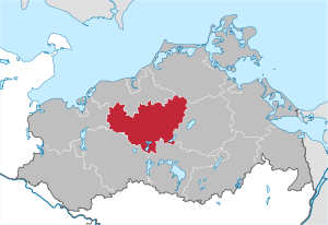
| Location of the district of Güstrow in Mecklenburg-Western Pomerania | |
  |
|
The district of Güstrow was a district in Mecklenburg-Western Pomerania that was merged with the district of Bad Doberan to form the district of Rostock as part of the district reform in 2011 .
geography
The district of Güstrow was in the middle of the state of Mecklenburg-Western Pomerania. Neighboring districts were in the northern part of the district of Bad Doberan , in the northeastern district of North Western Pomerania in the east of the district of Demmin , in the south of the Müritz district , in the southwest of Parchim and west of the nordwestmecklenburg . A district of the same name already existed from 1939 to 1952, but with a different area.
The district of Güstrow lies between the Hanseatic city of Rostock in the north and the Mecklenburg Lake District in the south. In the northwest the Warnow flows through the district area, in the southeast the Peene rises .
history
In 1925, the Güstrow office was formed in Mecklenburg-Schwerin from the Bützow and Güstrow-Rossewitz offices. In 1933 the Güstrow district became the Güstrow district . The city of Güstrow remained independent. After Mecklenburg-Schwerin was united with Mecklenburg-Strelitz in 1934 to form a state of Mecklenburg , in 1939 the name of the district was changed to the district of Güstrow . In 1939, 204 communities with 56,314 inhabitants belonged to the district of Güstrow.
After the Second World War , the district belonged to the state of Mecklenburg-Western Pomerania in the Soviet occupation zone . The name of the country was changed to Mecklenburg in 1947 . Since 1949 it belonged to the GDR . In 1950 the city of Güstrow lost its district freedom and was incorporated into the district.
The old district of Güstrow was divided into three new districts on July 25, 1952 as part of the dissolution of the federal states. The core was formed by the Güstrow district , which had shrunk by more than half of its original area ; the Bützow district was created in the west and the Teterow district in the east . The districts of Güstrow and Bützow came to the district of Schwerin and the district of Teterow to the district of Neubrandenburg .
The regional reform in 1994 brought the three districts of Bützow, Güstrow and Teterow back together to form a common district of Güstrow - except for the area of the Schwaan office , which became part of the new Bad Doberan district . With the district reform of Mecklenburg-Western Pomerania in 2011 , the district of Güstrow was combined with the district of Bad Doberan to form the new district of Rostock . The district administrative seat was Güstrow.
politics
District Administrator
The district administrator of the district of Güstrow was the SPD politician Lutz da Cunha .
District council
The district assembly of the district of Güstrow consisted of 53 members. After the election on June 7, 2009, it was composed as follows:
| Faction / group | Seats |
|---|---|
| CDU | 18th |
| SPD | 11 |
| The left | 10 |
| Free voters, free voter community , individual applicants | 5 |
| FDP | 4th |
| Alliance 90 / The Greens * | 2 |
| NPD * | 2 |
| ON * | 1 |
| * no parliamentary group, as the minimum strength (4) is not reached |
The district (constituency number 53) consists of 134 electoral districts with 86,690 eligible voters. 37,690 went to the polls, casting 3,758 invalid and 106,408 valid votes. This corresponds to a voter turnout of around 43.5% (all data from 2009).
More information on the electoral process and legal provisions : District Council (Mecklenburg-Western Pomerania)
coat of arms
The coat of arms was approved by the Ministry of the Interior on August 16, 1996 and registered under the number 110 of the coat of arms of Mecklenburg-Western Pomerania.
Blazon : “Divided; Above, in gold, a black bull's head looking forward with a closed mouth, an open red tongue and silver horns, on the forehead a golden crown of princes, of which five prongs alternately decorated with leaf ornaments and pearls are visible, each with a red star; below in a field divided by red and gold, two diagonally crossed bishop's staffs in mixed up colors. "
The coat of arms was created by the parumer Dr. Dietrich bridegroom designed.
traffic
The Autobahn 19 runs through the district of Güstrow from Rostock in the direction of Berlin as well as the federal highways 103, 104 and 108. Approx. Rostock-Laage Airport is 20 km north of Güstrow . Scheduled flights to Munich , Cologne and Nuremberg as well as charter flights ( Spain / Balearic Islands , Morocco , Turkey , Egypt etc.) start from there.
cities and communes
(All population figures as of December 31, 2010)
Offices with official municipalities / cities
* Seat of the official administration
Territory changes
In the years since 1994 , extensive area changes have taken place in the area of the Güstrow district, as in the entire state of Mecklenburg-Western Pomerania.
After the regional reform was completed on January 1, 2005, the original 9 offices became six offices. The cities of Bützow and Laage lost their freedom of office. The number of parishes decreased from 98 to 62.
Office dissolutions, office mergers
- Merger of the offices of Jördenstorf and Teterow-Land to form the new office of Mecklenburg Switzerland (June 1, 2004)
- Dissolution of the Lalendorf office - incorporation into the Krakow am See office (July 1, 2004)
- Merger of the city of Laage with the Laage-Land office to form the new Laage office (August 1, 2004)
- Merger of the city of Bützow with the Bützow-Land office (January 1, 2005)
- Dissolution of the Steintanz-Warnowtal office - incorporation of the communities Baumgarten, Dreetz, Tarnow and Warnow into the Bützow-Land office and the Gülzow-Prüzen municipality into the Güstrow-Land office (January 1, 2005)
Incorporation, new congregations
- Dissolution of the community Gnemern - incorporation into Klein Sien (October 1, 1991)
- Dissolution of the Gerdshagen community - incorporation into Lohmen and formation of the Klein Upahl community from the Gerdshagen district of the same name (October 1, 1991)
- Spin-off of Remliner hamlet Granzow after Altkalen (6 October 1992)
- Dissolution of the community of Viezen - incorporation into Bernitt (July 1, 1995)
- Dissolution of the municipalities of Lübzin and Rosenow - reorganization of the municipality of Lübzin-Rosenow (June 1, 1998)
- Dissolution of the Kleverhof community - incorporation into Altkalen (January 1, 1999)
- Dissolution of the municipalities Katelbogen and Qualitz - incorporation into Baumgarten (January 1, 1999)
- Dissolution of the Parkow community - incorporation into Bützow (January 1, 1999)
- Dissolution of the Boitin community - incorporation into Tarnow (June 13, 1999)
- Dissolution of the community Groß Nieköhr - incorporation into Behren-Lübchin (December 31, 1999)
- Dissolution of the municipalities of Sabel and Striesdorf - new formation of the municipality of Dolgen am See (December 31, 1999)
- Dissolution of the communities of Göllin , Kurzen Trechow , Moisall and Schlemmin - incorporation after Bernitt (January 1, 2000)
- Dissolution of the Klein Sien community - incorporation into Jürgenshagen (January 1, 2000)
- Dissolution of the municipality of Zernin - incorporation into Tarnow (January 1, 2000)
- Dissolution of the community of Lübzin-Rosenow - incorporation into Warnow (January 1, 2000)
- Dissolution of the municipalities Dobbin and Linstow - reorganization of the municipality Dobbin-Linstow (January 1, 2000)
- Dissolution of the community of Oettelin - incorporation into Zepelin (July 1, 2001)
- Dissolution of the communities of Vietgest and Mamerow - incorporation into Lalendorf (July 1, 2001)
- Dissolution of the community of Charlottenthal - incorporation into Krakow am See (January 1, 2002)
- Dissolution of the community Groß Ridsenow - incorporation into Wardow (January 1, 2002)
- Dissolution of the municipality of Pölitz - incorporation into Diekhof (January 1, 2004)
- Dissolution of the community Wattmannshagen - incorporation into Lalendorf (January 1, 2004)
- Dissolution of the Alt Kätwin community - incorporation into Wardow (January 1, 2004)
- Dissolution of the community of Matgendorf - incorporation into Groß Wüstenfelde (June 13, 2004)
- Dissolution of the municipality of Bülow (near Güstrow) - incorporation into Gutow (June 13, 2004)
- Dissolution of the Liessow community - incorporation into Laage (June 13, 2004)
- Dissolution of the municipalities of Gülzow and Prüzen - reorganization of the municipality of Gülzow-Prüzen (June 13, 2004)
- Dissolution of the municipalities of Bristow and Bülow (near Malchin) - new formation of the municipality of Schorssow (June 13, 2004)
- Dissolution of the communities of Poggelow and Remlin - new formation of the community of Schwasdorf (June 13, 2004)
- Dissolution of the municipalities of Levitzow and Sukow-Marienhof - new formation of the municipality of Sukow-Levitzow (June 13, 2004)
- Dissolution of the Neu Heinde community - incorporation into Prebberede (June 13, 2004)
- Dissolution of the Bellin municipality - incorporation into Krakow am See (January 1, 2005)
- Dissolution of the municipality of Recknitz - incorporation into Plaaz (January 1, 2005)
- Dissolution of the Neuendorf community - incorporation into Steinhagen (January 1, 2005)
- Dissolution of the community of Weitendorf - incorporation into Laage (July 1, 2006)
Name changes
- from Bölkow community to Mühl Rosin community (April 25, 1991)
License Plate
At the beginning of 1991 the district received the distinguishing mark GÜ . It was issued until January 31, 2012. It has been available in the Rostock district since March 18, 2013 due to the license plate liberalization .
Web links
Individual evidence
- ^ Michael Rademacher: German administrative history from the unification of the empire in 1871 to the reunification in 1990. guestrow.html. (Online material for the dissertation, Osnabrück 2006).
- ↑ Mecklenburg-Western Pomerania Statistical Office - population development of the districts and municipalities 2010 (PDF; 522 kB)
Independent cities
State capital Schwerin |
Greifswald |
Rostock |
Stralsund |
Wismar |
Neubrandenburg
Districts of
Ostvorpommern |
Rügen |
North Western Pomerania |
Bad Doberan |
Guestrow |
Northwest Mecklenburg |
Ludwigslust |
Parchim |
Müritz |
Demmin |
Mecklenburg-Strelitz |
Uecker-Randow