
Thürkow
| coat of arms | Germany map | |
|---|---|---|

|
Coordinates: 53 ° 49 ' N , 12 ° 34' E |
|
| Basic data | ||
| State : | Mecklenburg-Western Pomerania | |
| County : | Rostock | |
| Office : | Mecklenburg Switzerland | |
| Height : | 11 m above sea level NHN | |
| Area : | 14.61 km 2 | |
| Residents: | 375 (Dec. 31, 2019) | |
| Population density : | 26 inhabitants per km 2 | |
| Postal code : | 17168 | |
| Area code : | 039975 | |
| License plate : | LRO, BÜZ, DBR, GÜ, ROS, TET | |
| Community key : | 13 0 72 109 | |
| Office administration address: | von-Pentz-Allee 7 17166 Teterow |
|
| Website : | ||
| Mayor : | Berthold Falkenau | |
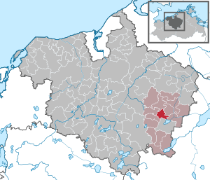
| Location of the municipality of Thürkow in the Rostock district | ||
  |
||

Thürkow is a municipality in the Rostock district in Mecklenburg-Western Pomerania (Germany). The municipality is administered by the Mecklenburg Switzerland Office with its seat in the non-official city of Teterow .
geography
The municipality of Thürkow in the west of Mecklenburg Switzerland is 6 km north of Teterow, in the valley of the Thürkower Bach brook into the lowlands around Lake Teterow . The Hilgenberg rises on the south-western slope of the valley - at 71 m above sea level. NN about 60 m above the east lying lowland, which belongs to the nature park Mecklenburgische Schweiz and Kummerower See .
Thürkow is surrounded by the neighboring communities Groß Wüstenfelde in the north, Sukow-Levitzow in the east, Alt Sührkow in the south-east, Teterow in the south, Dalkendorf in the south-west and Warnkenhagen in the north-west.
The district of Todendorf is part of the Thürkow community.
history
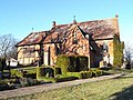
Thürkow was first mentioned in a deed of ownership in 1371 as a feudal estate . Landowners were u. a. the families von Barold (1415–1481), von Zeppelin (1481–1796) and Wilhelm Blohm (1866–1915) from 1890 onwards. The tenant house from around 1890 now houses a day-care center, among other things.
The early Gothic village church dates from the 13th century. Due to the relatively steep gradient of the Thürkower Bach, a small hydroelectric power station was built in 1999 on the site of a former water mill.
Todendorf was first attested in 1304. The manor house in the district is a specialty: Built in 1860 in a classical style, it was sponsored by the Association of German-Japanese Friends of Todendorf e. V. expanded as Schloss Mitsuko into a German-Japanese cultural center, which has been used as an exhibition and event building since 2001. The manor park has the shape of a Japanese grove with stone settings, exotic plants and the Shōkaku Mon (gate of the flying crane). The castle is named after the Japanese wife of the artist Heinrich Johann Radeloff, who has lived in Kyōto since 1964 : the "light-bringing".
The railway embankment-like Schwetziner Os runs near Todendorf , an almost 35 km long mountain range towards the north, which reflects the crevasse network of the inland ice .
Transport links
The community is located on the B 108 from Teterow to Rostock . In Thürkow, the state road branches off to the small town of Gnoien . The railway line from Teterow to Gnoien , on whose route Thürkow lay, was shut down in 1997. The nearest train station is in Teterow ( Güstrow – Neubrandenburg line ).
Personalities
- Georg Blohm (1896–1982), agricultural scientist
Attractions
- late Gothic church in Thürkow from the 15th century
- Classicist manor house in Todendorf from 1860
- Thürkow estate tenant house as a renovated clinker building from around 1890 with a central projectile and stepped gable
Village church

Mitsuko Castle


Web links
Individual evidence
- ↑ Statistisches Amt MV - population status of the districts, offices and municipalities 2019 (XLS file) (official population figures in the update of the 2011 census) ( help ).
- ^ Wolf Lüdeke von Weltzien: Families from Mecklenburg and Western Pomerania. Volume 3, Nagold 1992, p. 28.
- ↑ Dehio-Handbuch der Deutschen Kunstdenkmäler. Band Mecklenburg-Western Pomerania. 2016, ISBN 978-3-422-03128-9 , pp. 397/698.

Admannshagen-Bargeshagen | Old Bukow | Alt Sührkow | Altkalen | Am Salzhaff | Bad Doberan | Bartenshagen-Parkentin | Bastorf | Baumgarten | Behren-Lübchin | Benitz | Bentwisch | Bernitt | Biendorf | Blankenhagen | Börgerende-Rethwisch | Bröbberow | Broderstorf | Bützow | Cammin | Carinerland | Dahmen | Dalkendorf | Dobbin-Linstow | Dolgen am See | Dreetz | Dummerstorf | Elmenhorst / Lichtenhagen | Finkenthal | Gelbensande | Glasewitz | Gnewitz | Gnoien | Graal-Müritz | Grammow | Great Roge | Groß Schwiesow | Big wokers | Groß Wüstenfelde | Gülzow-Prüzen | Guestrow | Gutow | High demzin | Hohen Sprenz | Hohenfelde | Hoppenrade | Jördenstorf | Juergenshagen | Kassow | Klein Belitz | Klein Upahl | Krakow am See | Kritzmow | Kröpelin | Kuchel miss | Kühlungsborn | Cow | Laage | Lalendorf | Lambrechtshagen | Lelkendorf | Wages | Lüssow | Mistorf | Mönchhagen | Mühl Rosin | Neubukow | Nienhagen | Nustrow | Papendorf | Penzin | Plaaz | Pölchow | Poppendorf | Prebberede | Reddelich | Reimershagen | Rerik | Retschow | Rye | Rövershagen | Rühn | Rukieten | Sanitz | Sarmstorf | Satow | Schorssow | Swaan | Schwasdorf | Selpin | Stäbelow | Steffenshagen | Steinhagen | Stubbendorf | Sukow-Levitzow | Tarnow | Ticino | Teterow | Thelkow | Thulendorf | Thürkow | Vorbeck | Walkendorf | Wardow | Warnkenhagen | Warnow | Wiendorf | Wittenbeck | Zarnewanz | Zehna | Zepelin | Ziesendorf