
Retschow
| coat of arms | Germany map | |
|---|---|---|

|
Coordinates: 54 ° 3 ' N , 11 ° 53' E |
|
| Basic data | ||
| State : | Mecklenburg-Western Pomerania | |
| County : | Rostock | |
| Office : | Bad Doberan Country | |
| Height : | 81 m above sea level NHN | |
| Area : | 18.87 km 2 | |
| Residents: | 943 (Dec. 31, 2019) | |
| Population density : | 50 inhabitants per km 2 | |
| Postal code : | 18211 | |
| Primaries : | 038203, 038292 | |
| License plate : | LRO, BÜZ, DBR, GÜ, ROS, TET | |
| Community key : | 13 0 72 086 | |
| Office administration address: | Kammerhof 3 18209 Bad Doberan |
|
| Website : | ||
| Mayor : | Thomas Schubert | |
| Location of the municipality Retschow in the Rostock district | ||
  |
||

Retschow is a municipality in the Rostock district in Mecklenburg-Western Pomerania (Germany). The municipality is administered by the Bad Doberan-Land office , based in Bad Doberan .
The place name is derived from the Slavic word "rez" = rye. This made Rezhecow - Retschow. The districts Fulgenkoppel, Glashagen and Stülow belong to Retschow.
geography
The municipality is located between the towns of Bad Doberan, Kröpelin and the municipality of Satow in a hilly area that adjoins the cooling ridge to the southeast .
Retschow is surrounded by the neighboring communities of Bad Doberan in the north, Hohenfelde in the east, Satow in the south, Kröpelin in the west and Reddelich in the northwest.
history
During the Wars of Liberation near Retschow on August 28, 1813, a battle took place between the left wing of Napoleon's armies under François Antoine Lallemand , who had advanced to Mecklenburg in August 1813, and the Northern Army with Mecklenburg volunteer hunters under Swedish command. It ended with the withdrawal of the French troops.
politics
Community representation
The municipal council consists of eight members. The election to the municipal council on May 26, 2019 had the following results:
| Party / applicant | percent | Seats |
|---|---|---|
| Voting group action alliance | 34.9 | 3 |
| The left | 28.6 | 2 |
| Voting group FFW | 25.4 | 2 |
| SPD | 5.2 | 1 |
coat of arms
The coat of arms was approved by the Ministry of the Interior on October 26, 2000 and registered under the number 231 of the coat of arms of Mecklenburg-Western Pomerania.
Blazon : “Under a five-way tinned red shield head in green a fallen, curled golden tip, covered with a striding black rooster; in front and behind each a slanting outward golden ear. "
The red sky symbolizes the fire in Neubukow and the fire that destroyed the castle. The four battlements are reminiscent of the knight's castle, which was destroyed in the 14th century, and of the merger of the four districts of Retschow, Fulgenkoppel, Stülow and Glashagen to form the municipality of Retschow. In 1729 the black rooster crowed in the middle of the night in view of the red sky from the great fire in Neubukow. The local pastor alerted the Retschow people, who were now the first to help out to put out the fire and the ears of wheat symbolize the Slavic place name Retschow von Rezhecow = rye place (rez = rye).
The coat of arms was designed by Michael Zapfe from Weimar .
Culture and sights
→ See also the list of architectural monuments in Retschow
- Retschow village church : Gothic single-nave brick church, mentioned in 1233, with a single -bay choir ; the west tower in front was built from wood in 1653.
- Monument courtyard Pentzin: The museum depicts the rural world of life and work. The courtyard complex is the only one of its kind in Mecklenburg-Western Pomerania, which is divided into three parts: a residential house (1787), a barn (1836) and a retirement home (1842).
- Retschow manor
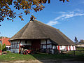
Museum courtyard in Retschow

black rooster


Web links
Retschow on amt-doberan-land.de
Individual evidence
- ↑ Statistisches Amt MV - population status of the districts, offices and municipalities 2019 (XLS file) (official population figures in the update of the 2011 census) ( help ).
- ↑ The battle at Retschow
- ↑ Election results on the website of the Bad Doberan Land Office (PDF)

Admannshagen-Bargeshagen | Old Bukow | Alt Sührkow | Altkalen | Am Salzhaff | Bad Doberan | Bartenshagen-Parkentin | Bastorf | Baumgarten | Behren-Lübchin | Benitz | Bentwisch | Bernitt | Biendorf | Blankenhagen | Börgerende-Rethwisch | Bröbberow | Broderstorf | Bützow | Cammin | Carinerland | Dahmen | Dalkendorf | Dobbin-Linstow | Dolgen am See | Dreetz | Dummerstorf | Elmenhorst / Lichtenhagen | Finkenthal | Gelbensande | Glasewitz | Gnewitz | Gnoien | Graal-Müritz | Grammow | Great Roge | Groß Schwiesow | Big wokers | Groß Wüstenfelde | Gülzow-Prüzen | Guestrow | Gutow | High demzin | Hohen Sprenz | Hohenfelde | Hoppenrade | Jördenstorf | Juergenshagen | Kassow | Klein Belitz | Klein Upahl | Krakow am See | Kritzmow | Kröpelin | Kuchel miss | Kühlungsborn | Cow | Laage | Lalendorf | Lambrechtshagen | Lelkendorf | Wages | Lüssow | Mistorf | Mönchhagen | Mühl Rosin | Neubukow | Nienhagen | Nustrow | Papendorf | Penzin | Plaaz | Pölchow | Poppendorf | Prebberede | Reddelich | Reimershagen | Rerik | Retschow | Rye | Rövershagen | Rühn | Rukieten | Sanitz | Sarmstorf | Satow | Schorssow | Swaan | Schwasdorf | Selpin | Stäbelow | Steffenshagen | Steinhagen | Stubbendorf | Sukow-Levitzow | Tarnow | Ticino | Teterow | Thelkow | Thulendorf | Thürkow | Vorbeck | Walkendorf | Wardow | Warnkenhagen | Warnow | Wiendorf | Wittenbeck | Zarnewanz | Zehna | Zepelin | Ziesendorf