
Bastorf
| coat of arms | Germany map | |
|---|---|---|

|
Coordinates: 54 ° 8 ' N , 11 ° 42' E |
|
| Basic data | ||
| State : | Mecklenburg-Western Pomerania | |
| County : | Rostock | |
| Office : | Neubukow-Salzhaff | |
| Height : | 51 m above sea level NHN | |
| Area : | 24.39 km 2 | |
| Residents: | 1073 (Dec. 31, 2019) | |
| Population density : | 44 inhabitants per km 2 | |
| Postal code : | 18230 | |
| Primaries : | 038293, 038294, 038296 | |
| License plate : | LRO, BÜZ, DBR, GÜ, ROS, TET | |
| Community key : | 13 0 72 008 | |
| LOCODE : | DE BY2 | |
| Office administration address: | Panzower Landweg 1 18233 Neubukow |
|
| Website : | ||
| Mayor : | Marko Porm | |
| Location of the municipality of Bastorf in the Rostock district | ||
  |
||

Bastorf is a municipality in the Rostock district in Mecklenburg-Western Pomerania (Germany). The community is administered by the Neubukow-Salzhaff office , based in the city of Neubukow .
Bastorf includes the districts of Hohen Niendorf , Kägsdorf, Mechelsdorf, Wendelstorf, Westhof and Zweedorf.
geography
The municipality of Bastorf is located between the Baltic Sea resorts of Kühlungsborn and Rerik along the coast in the northwest of the terminal moraine cooling . The municipality is not contiguous - the district of Zweedorf is an exclave . At Cape Bukspitze , the community has a two-kilometer-wide portion of the Baltic coast.
Bastorf is surrounded by the neighboring communities of Kühlungsborn in the northeast, Kröpelin in the southeast, Biendorf in the south and Rerik in the west.
history
On July 1, 1950, the previously independent municipality of Kägsdorf was incorporated.
politics
Community representation
The municipal council consists of 10 members. The election to the local council on June 7, 2009 had the following results:
| Party / applicant | percent | Seats |
|---|---|---|
| Groups of voters | 97.4 | 10 |
| Individual applicants | 2.6 | - |
coat of arms
The coat of arms was approved by the Ministry of the Interior on July 20, 2001 and registered under the number 248 of the coat of arms of Mecklenburg-Western Pomerania.
Blazon : "In gold on a green hill, a red lighthouse with a silver lantern and silver rays of light."
The coat of arms was designed by the Schwerin heraldist Heinz Kippnick .
Attractions
- The 20.8 meter high lighthouse Bastorf stands at 78 m above sea level. NN lying top of the Bastorfer Berg and thus after the lighthouse in Travemünde in second place of the German Baltic Sea lighthouses after the height of fire.
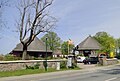
- Bastorf manor with thatched and listed thatched roof barns. These are typical of the hall house shapes that were once widespread . The specialty: a two-column house next to a three-column house.
- The neo-Gothic , two-storey, nine-axle manor house with a three-storey central risalit in Kägsdorf was built by Gottlieb von Brandt in the middle of the 19th century.
- The three-storey manor house in Hohen Niendorf , built around 1865, was converted into a hunting lodge in 1912.
- Several Neolithic stone graves in the districts of Hohen Niendorf and Mechelsdorf .
→ See also the list of architectural monuments in Bastorf

Bastorf lighthouse
Manor in Bastorf

Manor house in Kägsdorf

Manor house in Hohen Niendorf


Events
In Bastorf every summer in June the Zuparken Festival takes place around the beach car park, which offers a mixture of sport, creativity and music. There are z. B. Courses and competitions in stand-up paddleboarding , kitesurfing , windsurfing , skimboarding and surfing are offered. In addition, manufacturers of water sports accessories will present their equipment and offer festival guests tests. Many visitors arrive in nostalgic vehicles like the Bulli .
traffic
The community of Bastorf is located on state road 12 from Kühlungsborn to Neubukow. The Kröpelin connection to the federal motorway 20 is 27 kilometers away. The next rail connection ( Bäderbahn Molli ) is in Kühlungsborn, the next standard-gauge rail connection in Kröpelin. The Rerik-Zweedorf airfield is located within the municipal area and its grass runway can be used by small aircraft.
Web links
Individual evidence
- ↑ Statistisches Amt MV - population status of the districts, offices and municipalities 2019 (XLS file) (official population figures in the update of the 2011 census) ( help ).
- ↑ The election results of the regional returning officer on the website of the Statistical Office (PDF; 1.2 MB)
- ↑ zuparken Festival on Bastorf beach

Admannshagen-Bargeshagen | Old Bukow | Alt Sührkow | Altkalen | Am Salzhaff | Bad Doberan | Bartenshagen-Parkentin | Bastorf | Baumgarten | Behren-Lübchin | Benitz | Bentwisch | Bernitt | Biendorf | Blankenhagen | Börgerende-Rethwisch | Bröbberow | Broderstorf | Bützow | Cammin | Carinerland | Dahmen | Dalkendorf | Dobbin-Linstow | Dolgen am See | Dreetz | Dummerstorf | Elmenhorst / Lichtenhagen | Finkenthal | Gelbensande | Glasewitz | Gnewitz | Gnoien | Graal-Müritz | Grammow | Great Roge | Groß Schwiesow | Big wokers | Groß Wüstenfelde | Gülzow-Prüzen | Guestrow | Gutow | High demzin | Hohen Sprenz | Hohenfelde | Hoppenrade | Jördenstorf | Juergenshagen | Kassow | Klein Belitz | Klein Upahl | Krakow am See | Kritzmow | Kröpelin | Kuchel miss | Kühlungsborn | Cow | Laage | Lalendorf | Lambrechtshagen | Lelkendorf | Wages | Lüssow | Mistorf | Mönchhagen | Mühl Rosin | Neubukow | Nienhagen | Nustrow | Papendorf | Penzin | Plaaz | Pölchow | Poppendorf | Prebberede | Reddelich | Reimershagen | Rerik | Retschow | Rye | Rövershagen | Rühn | Rukieten | Sanitz | Sarmstorf | Satow | Schorssow | Swaan | Schwasdorf | Selpin | Stäbelow | Steffenshagen | Steinhagen | Stubbendorf | Sukow-Levitzow | Tarnow | Ticino | Teterow | Thelkow | Thulendorf | Thürkow | Vorbeck | Walkendorf | Wardow | Warnkenhagen | Warnow | Wiendorf | Wittenbeck | Zarnewanz | Zehna | Zepelin | Ziesendorf