
Carinerland
| coat of arms | Germany map | |
|---|---|---|

|
Coordinates: 53 ° 59 ' N , 11 ° 43' E |
|
| Basic data | ||
| State : | Mecklenburg-Western Pomerania | |
| County : | Rostock | |
| Office : | Neubukow-Salzhaff | |
| Height : | 60 m above sea level NHN | |
| Area : | 52.36 km 2 | |
| Residents: | 1247 (Dec. 31, 2019) | |
| Population density : | 24 inhabitants per km 2 | |
| Postcodes : | 18233 (Bolland, Kamin, Kirch Mulsow, Krempin, Ravensberg, Zarfzow) , 18236 (Alt Karin, Danneborth, Neu Karin) |
|
| Primaries : | 038294, 038297 | |
| License plate : | LRO, BÜZ, DBR, GÜ, ROS, TET | |
| Community key : | 13 0 72 022 | |
| Office administration address: | Panzower Landweg 1 18233 Neubukow |
|
| Website : | ||
| Mayoress : | Heike Chrzan-Schmidt | |
| Location of the municipality of Carinerland in the Rostock district | ||
  |
||

Carinerland is a municipality in the northwest of the Rostock district in Mecklenburg-Western Pomerania . The community is administered by the Neubukow-Salzhaff office , based in the city of Neubukow .
geography
The municipality of Carinerland is located in a ground moraine area between the Hanseatic city of Wismar and the city of Bad Doberan , about 13 kilometers southeast of the Salzhaff . The municipality borders in the south on the district of Northwest Mecklenburg .
Carinerland is surrounded by the neighboring communities of Biendorf in the north, Kröpelin in the northeast, Satow in the east, Passee in the southeast, Züsow in the south, Neuburg in the southwest, Alt Bukow in the west and Neubukow in the northwest.
Community structure
The municipality is made up of the districts of Alt Karin, Bolland, Danneborth, Kamin, Kirch Mulsow , Klein Mulsow, Krempin, Moitin, Neu Karin, Ravensberg and Zarfzow.
history
The community was formed on March 15, 2004 from the previously independent communities of Kamin, Karin , Krempin and Ravensberg. On May 26, 2019, the Kirch Mulsow community was added.
Attractions

Village church in Alt Karin

Church clock of the village church
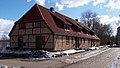
Reaper's hut in Alt Karin


Web links
Individual evidence
- ↑ Statistisches Amt MV - population status of the districts, offices and municipalities 2019 (XLS file) (official population figures in the update of the 2011 census) ( help ).
- ↑ StBA Area: changes from 01.01. until December 31, 2004
- ^ Statistical Office Mecklenburg-Western Pomerania: Area changes in Mecklenburg-Western Pomerania. 19.03.2019 to 06.05.2019

Admannshagen-Bargeshagen | Old Bukow | Alt Sührkow | Altkalen | Am Salzhaff | Bad Doberan | Bartenshagen-Parkentin | Bastorf | Baumgarten | Behren-Lübchin | Benitz | Bentwisch | Bernitt | Biendorf | Blankenhagen | Börgerende-Rethwisch | Bröbberow | Broderstorf | Bützow | Cammin | Carinerland | Dahmen | Dalkendorf | Dobbin-Linstow | Dolgen am See | Dreetz | Dummerstorf | Elmenhorst / Lichtenhagen | Finkenthal | Gelbensande | Glasewitz | Gnewitz | Gnoien | Graal-Müritz | Grammow | Great Roge | Groß Schwiesow | Big wokers | Groß Wüstenfelde | Gülzow-Prüzen | Guestrow | Gutow | High demzin | Hohen Sprenz | Hohenfelde | Hoppenrade | Jördenstorf | Juergenshagen | Kassow | Klein Belitz | Klein Upahl | Krakow am See | Kritzmow | Kröpelin | Kuchel miss | Kühlungsborn | Cow | Laage | Lalendorf | Lambrechtshagen | Lelkendorf | Wages | Lüssow | Mistorf | Mönchhagen | Mühl Rosin | Neubukow | Nienhagen | Nustrow | Papendorf | Penzin | Plaaz | Pölchow | Poppendorf | Prebberede | Reddelich | Reimershagen | Rerik | Retschow | Rye | Rövershagen | Rühn | Rukieten | Sanitz | Sarmstorf | Satow | Schorssow | Swaan | Schwasdorf | Selpin | Stäbelow | Steffenshagen | Steinhagen | Stubbendorf | Sukow-Levitzow | Tarnow | Ticino | Teterow | Thelkow | Thulendorf | Thürkow | Vorbeck | Walkendorf | Wardow | Warnkenhagen | Warnow | Wiendorf | Wittenbeck | Zarnewanz | Zehna | Zepelin | Ziesendorf