
Elmenhorst / Lichtenhagen
| coat of arms | Germany map | |
|---|---|---|

|
Coordinates: 54 ° 9 ' N , 12 ° 1' E |
|
| Basic data | ||
| State : | Mecklenburg-Western Pomerania | |
| County : | Rostock | |
| Office : | Warnow-West | |
| Height : | 13 m above sea level NHN | |
| Area : | 12.09 km 2 | |
| Residents: | 4265 (Dec. 31, 2019) | |
| Population density : | 353 inhabitants per km 2 | |
| Postal code : | 18107 | |
| Primaries : | 0381, 038203 | |
| License plate : | LRO, BÜZ, DBR, GÜ, ROS, TET | |
| Community key : | 13 0 72 030 | |
| Office administration address: | Schulweg 1a 18198 Kritzmow |
|
| Website : | ||
| Mayor : | Uwe Barten (independent) | |
| Location of the municipality of Elmenhorst / Lichtenhagen in the Rostock district | ||
  |
||

Elmenhorst / Lichtenhagen is a municipality in the Rostock district in Mecklenburg-Western Pomerania, Germany. It is administered by the Warnow-West office based in the municipality of Kritzmow .
geography
Geographical location
The municipality of Elmenhorst / Lichtenhagen is located in the " Hägerort " area between the lower Warnow and Bad Doberan in the immediate vicinity of the Baltic Sea coast . The municipality includes an almost one kilometer long landscape protection area directly on the steep coast of the Stoltera .
Elmenhorst / Lichtenhagen is surrounded by the Rostock districts of Diedrichshagen in the northeast, Lichtenhagen and Lütten Klein in the east, Evershagen in the southeast and the communities Admannshagen-Bargeshagen in the southwest and Nienhagen in the west.

Community structure
The community consists of the places Elmenhorst and Lichtenhagen.
history
The merger of the two districts to form the municipality of Elmenhorst took place in 1960. The place name was changed to Elmenhorst / Lichtenhagen on January 14, 1992.
From 1952 to 1994 the community belonged to the Rostock-Land district (until 1990 in the GDR district of Rostock , 1990–1994 in the state of Mecklenburg-Western Pomerania). In 1994 it was incorporated into the Bad Doberan district. Since the district reform in 2011 , it has been in the Rostock district .
Elmenhorst
The elongated street village of Elmenhorst was first mentioned in a document in 1328.
Lichtenhagen
The Angerdorf Lichtenhagen was first mentioned in 1264 by the naming of a parishioner Burchard, the church Lychtenhagen first in 1319. The building of the church took place earlier. The village name indicates a German foundation and means something like "clear spot in the forest". The ending -hagen indicates an earlier clearing with fencing, probably by hedges.
In the second half of the 15th century the village belonged to a Nikolaus Hasenkop and his sons Hermann and Nikolaus. A branch of the von Schnakenburg family, who owned the village and today's Rostock district of Diedrichshagen until 1359, also lived here. At the beginning of the 14th century, Lichtenhagen belonged to the von Gummern family. On January 3, 1505, the widow of the last owner, Klaus von Gummern, sold the property of the Lichtenhagen, Lambrechtshagen and Bliesekow estates to the dukes Balthasar and Heinrich V. Hans von Gummern, a nephew of Klaus, tried in 1531 by filing a complaint with the united estates to reclaim the property, but was subject. So Lichtenhagen remained in the ducal domanial association.
Population development
Contrary to the trend in Mecklenburg-Western Pomerania, the number of inhabitants almost quadrupled between 1990 and 2019, which is due to the proximity to the Hanseatic city of Rostock and access to the coast.
|
|
Status: December 31 of the respective year
politics
Community representation
The municipal council of Elmenhorst / Lichtenhagen consists of 14 members and the mayor. Since the local elections in 2019, it has been composed as follows:
| Party / group of voters | be right | Seats |
| CDU | 35.7% | 5 |
| Voting group "Das Dorf" | 34.2% | 5 |
| FDP | 12.6% | 2 |
| The left | 12.2% | 1 |
| SPD | 5.3% | 1 |
mayor
- 2002–2019: Horst Harbrecht (CDU)
- since 2019: Uwe Barten (independent)
Barten was elected in the mayoral election on June 16, 2019 with 86.8% of the valid votes for a term of five years.
coat of arms
The coat of arms was approved on September 17, 1993 by the Ministry of the Interior and registered under number 59 of the coat of arms of Mecklenburg-Western Pomerania.
Blazon : “Split; in front in gold and in back in blue a front of a gallery Dutch windmill in mixed up colors. "
The coat of arms was designed by Roland Bornschein from Wismar.
Attractions

- Lichtenhagen village church made of mostly uncut boulders, dates from the transition from Romanesque to Gothic , was built at various times through several renovations. The 13th century choir is the oldest part of the church.
- Village center Lichtenhagen with thatched farmhouses ( Low German hall houses )
- Two Dutch windmills (built in 1836 and 1879), the artist Feliks Büttner lives and works in the mill built in 1836
- Meridian latitude marking to mark the 12th degree east longitude, which runs through Elmenhorst

Historical farm

Historic farmhouse
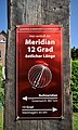
Meridian plaque

Circle of latitude badge


Economy and Infrastructure
Companies
The town's economy is shaped by its proximity to the Baltic Sea and the associated tourism. The Sonnländer Getränke GmbH with the regional brand "Elmenhorster" operates plants for juice extraction as well as its processing and bottling in the immediate vicinity.
traffic
Elmenhorst / Lichtenhagen is on the L 12 state road between Bad Doberan and Rostock- Warnemünde . The district road K 10 connects the towns with the federal road B 103 between Warnemünde in the north and the Rostock-West junction on the A 20 ( Lübeck - Uckermark triangle ) in the south.
The nearest train station is Rostock-Lütten Klein on the Rostock Hbf – Warnemünde railway line . It is served by the S-Bahn lines S1, S 2 and S3.
Web links
Individual evidence
- ↑ Statistisches Amt MV - population status of the districts, offices and municipalities 2019 (XLS file) (official population figures in the update of the 2011 census) ( help ).
- ↑ Main statute of the municipality of Elmenhorst / Lichtenhagen, § 1
- ↑ Population development of the districts and municipalities in Mecklenburg-Western Pomerania (Statistical Report AI of the Statistical Office Mecklenburg-Western Pomerania)
- ^ Result of the local election on May 26, 2019
- ↑ New plan for the L-12 bypass. In: North German Latest News , February 12, 2014.
- ^ Result of the mayoral election on June 16, 2019

Admannshagen-Bargeshagen | Old Bukow | Alt Sührkow | Altkalen | Am Salzhaff | Bad Doberan | Bartenshagen-Parkentin | Bastorf | Baumgarten | Behren-Lübchin | Benitz | Bentwisch | Bernitt | Biendorf | Blankenhagen | Börgerende-Rethwisch | Bröbberow | Broderstorf | Bützow | Cammin | Carinerland | Dahmen | Dalkendorf | Dobbin-Linstow | Dolgen am See | Dreetz | Dummerstorf | Elmenhorst / Lichtenhagen | Finkenthal | Gelbensande | Glasewitz | Gnewitz | Gnoien | Graal-Müritz | Grammow | Great Roge | Groß Schwiesow | Big wokers | Groß Wüstenfelde | Gülzow-Prüzen | Guestrow | Gutow | High demzin | Hohen Sprenz | Hohenfelde | Hoppenrade | Jördenstorf | Juergenshagen | Kassow | Klein Belitz | Klein Upahl | Krakow am See | Kritzmow | Kröpelin | Kuchel miss | Kühlungsborn | Cow | Laage | Lalendorf | Lambrechtshagen | Lelkendorf | Wages | Lüssow | Mistorf | Mönchhagen | Mühl Rosin | Neubukow | Nienhagen | Nustrow | Papendorf | Penzin | Plaaz | Pölchow | Poppendorf | Prebberede | Reddelich | Reimershagen | Rerik | Retschow | Rye | Rövershagen | Rühn | Rukieten | Sanitz | Sarmstorf | Satow | Schorssow | Swaan | Schwasdorf | Selpin | Stäbelow | Steffenshagen | Steinhagen | Stubbendorf | Sukow-Levitzow | Tarnow | Ticino | Teterow | Thelkow | Thulendorf | Thürkow | Vorbeck | Walkendorf | Wardow | Warnkenhagen | Warnow | Wiendorf | Wittenbeck | Zarnewanz | Zehna | Zepelin | Ziesendorf