Hägerort
The name Hägerort (also Häger Ort or Häger Ort ) denotes a region northwest of Rostock. The name comes from the accumulation of places with names of German origin with the ending -hagen , while most place names in the vicinity are of Slavic origin. During the times of Slavic settlement, the Drenow was here , an extensive forest area that was only cleared by German settlers. The place names on -hagen indicate the origins of the places in cleared areas.
location
The Hägerort is an area about twelve by twelve kilometers that is bordered to the south by the Rostock – Bad Doberan railway line and to the north by the Baltic Sea. In the east, the Hägerort ends west of the Unterwarnow .
The place names of: Admannshagen , Allershagen , Bargeshagen , Bartenshagen , Diedrichshagen , Evershagen , Lambrechtshagen , Lichtenhagen , Nienhagen, Sievershagen end in -hagen . The other places in this area (Börgerende, Elmenhorst, Rabenhorst, Rethwisch, Steinbeck) also have names of German origin, while the surrounding regions are dominated by names of Slavic origin, e.g. B. Rostock , Bad Doberan , Parkentin , (Lütten) Klein (from Slavic Klenow, Ahornort).
The swampy area around the Conventer See north of Bad Doberan is usually regarded as the western border of the Hägerort . Individual sources also include the region east of the cooling north-west of Bad Doberan, where there are also some places on -hagen ( Steffenshagen , Brodhagen , Vorder- Mittel- and Klein Bollhagen).
The names of the Rostock new development areas Lichtenhagen and Evershagen, built in the 1970s, are derived from the neighboring old villages of the Hägerort, while the name Reutershagen is based on the names of the neighboring villages from the 1920s for a settlement that was created at that time. The small town of Walkenhagen northeast of Bad Doberan is mentioned as a day laborer settlement in the 19th century.
The area is a flat, undulating ground moraine landscape . With a few exceptions (the Ehbruch south of Nienhagen, the Mönkweden near Lambrechtshagen and the coastal forests of Stolteraa near Diedrichshagen and Nienhäger Holz (known as the ghost forest ) near Nienhagen ), the Hägerort is not forested today.
Most of the Hägerort is in the Rostock district, the village of Evershagen and part of the former Lichtenhäger Flur belong to the Rostock urban area.
history
In pre-Christian times, the region west of the Warnow estuary was inhabited by pagan Slavs who settled around the extensive forest area of the Drenow (the name probably comes from a Slavic word for “tree”), but did not inhabit the forest. Around the year 1200, Prince Heinrich Borwin I , Prince of Mecklenburg and Lord of Rostock, called on "Christian settlers from near and far" to settle in the "land poor in people and devoted to the service of demons". Starting from Doberan Monastery , the clearing of the Drenow forests and the settlement of the area began. The new villages had a special legal status, the farmers were allowed to cultivate hooves , which were twice the size of the usual German hooves and four times the size of the Slavic ones.
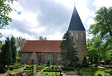
The oldest churches in the area are the village churches of Lichtenhagen and Lambrechtshagen from the first half of the 13th century.
While the Slavic villages were usually laid out in the shape of a round or horseshoe, the shape of a street village dominated the new German villages. Particularly exposed representatives of this type of investment are the elongated villages of Allershagen or Bartenshagen. The traditional black costume was known in many villages in the region until the 20th century.
Most of the settlements in Hägerort remained farming villages until the 20th century. Exceptions were Evershagen, which was owned by the Jakobikirche in Rostock , and parts of Lambrechtshagen and Nienhagen, where there was a share of the estate in addition to the rural ones. The villages of Rabenhorst and Steinbeck, which do not end in -hagen, were also manor villages before the Second World War.
Natural space
In the list of natural units in Mecklenburg-Western Pomerania of the State Environment Ministry, the natural area 110 Häger Ort is included. It belongs to landscape unit 11 Unterwarnow area of the large landscape 1 Baltic Sea coast country . The natural area Hägerort covers a somewhat larger area than the historical Hägerort. Its southwestern border runs along a line from Kühlungsborn via Bad Doberan (excluding the towns) to Stäbelow. The other borders of the area run along the line from Stäbelow to Papendorf , the Warnow to the mouth and the Baltic Sea from Warnemünde to Kühlungsborn. A large part of the city of Rostock is part of the natural area.
Individual evidence
- ^ Journal of geopolitics , Volume 31 (1960), p. 24.
- ^ Section Hägerort , in: Rostocker Heimat , Verlag Bibliographisches Institut, Leipzig 1955, p. 117.
- ↑ Timetable of the Elmenhorst / Lichtenhagen community accessed on January 12, 2020.
- ^ A b c Georg Christian Friedrich Lisch , The Rostocker Bauerntracht und das Land Drenow , in: Yearbooks of the Association for Mecklenburg History and Antiquity, Volume 39, pp. 97-100.
- ^ Mecklenburgisches Ortverzeichnis 1930, towns and localities of the states Mecklenburg-Schwerin and Mecklenburg Strelitz , Verlag Boldt, 1930.

