Unterwarnow
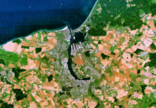
The Unterwarnow is the estuary of the Warnow River and extends from Rostock's old town to Warnemünde, where it flows into the Mecklenburg Bay . Hydrologically it is a bay of the Baltic Sea , an inner coastal body of water . In the northern part of the Unterwarnow, the salt content is as high as in the Wismar Bay or the open Baltic Sea in the area of the Darßer Schwelle .
The Rostock city harbor and the old town of Rostock are on the southern bank, and the Rostock district of Gehlsdorf is on the northern bank . In the further course the Unterwarnow turns to the north. The districts of Bramow, Marienehe , Schmarl and Groß Klein are located on the western bank, where the Carbäk and Schmarler Bach and Laak Canal also flow . The small Rostock districts of Langenort, Warnowrande and Oldendorf are located on the eastern bank. The Warnow tunnel crosses the river between Schmarl and Oldendorf . The Rostock seaport area begins north of Oldendorf on the eastern bank. Shortly afterwards, the river in the haff-like Breitling widens to up to three kilometers.
The connection between the Unterwarnow and the open Baltic Sea in the Rostock district of Warnemünde is formed by a canal called Neuer Strom / Seekanal . The Neue Strom / Seekanal , opened in 1903 and expanded in 1958, is the entrance to the Rostock ports and is 14.5 meters deep. The Hohe Düne district lies on its eastern bank . The New Stream has a seaward surface current and a southward deep current. The Alte Strom in Warnemünde, today a port for cutter fishermen, excursion boats and yachts, is the original estuary of the Warnow. Until the end of the 20th century, it was connected to the Unterwarnow by a tunnel-like canal that could be navigated by small boats. After this connection was filled in during the expansion of the Warnemünde Cruise Port , this passage was later reopened, as the lack of the connection had negative effects on the water exchange and the water levels in the old river. The passage crosses under the street and the railway tracks to Warnemünde train station .
The Unterwarnow is navigable for ocean-going ships from the mouth to the Rostock city harbor . The Rostock port facilities are located at Unterwarnow and Breitling.
On the banks of the Unterwarnow there are many sport boat harbors, jetties and marinas , for example in the city harbor, in Gehlsdorf, Marienehe , Schmarl , Oldendorf and Warnemünde.
A number of excursion boats from various shipping companies operate on the Unterwarnow, including regular services between the city harbor and Warnemünde. A passenger ferry connects Gehlsdorf and the Kröpeliner-Tor-Vorstadt . There is a car ferry between Warnemünde and Hohe Düne .
The narrow stretch of the Unterwarnow river from the lower head of the lock on Mühlendamm, which has existed since 1882, to the eastern end of the Rostock city port (km 143.00) is a federal class I inland waterway . From here to the open Baltic Sea, Unterwarnow is a federal sea waterway. The shipping route regulations apply to both sections of the route . The Stralsund Waterways and Shipping Office is responsible .
proof
- ↑ ikzm-d.de waters typology according to EU - Water Framework Directive : To Map 1.5 counts the Unterwarnow neither the rivers nor to the lakes of Mecklenburg-Vorpommern.
- ↑ Images and profile measurements for the coastal water report from January to July 2005 ( memento of the original from September 23, 2015 in the Internet Archive ) Info: The archive link was inserted automatically and has not yet been checked. Please check the original and archive link according to the instructions and then remove this notice.
- ↑ Typology of the German Baltic Sea coast for the EU Water Framework Directive; Salinity cards a. ( Memento of July 21, 2012 in the Internet Archive ) (PDF file; 490 kB)
- ↑ Lengths (in km) of the main shipping lanes (main routes and certain secondary routes) of the federal inland waterways ( memento of the original from January 21, 2016 in the Internet Archive ) Info: The archive link was inserted automatically and has not yet been checked. Please check the original and archive link according to the instructions and then remove this notice. , Federal Waterways and Shipping Administration
- ↑ Directory E, serial no. 61 der Chronik ( Memento of the original from July 22, 2016 in the Internet Archive ) Info: The archive link has been inserted automatically and has not yet been checked. Please check the original and archive link according to the instructions and then remove this notice. , Federal Waterways and Shipping Administration
literature
- M. Eckoldt (Hrsg.): Rivers and canals, The history of the German waterways. DSV-Verlag 1998.
Web links
- Federal Institute for Hydraulic Engineering: The morphological system of the Warnow estuary. (PDF; 561 kB) Retrieved October 22, 2013 .


