
Steffenshagen
| coat of arms | Germany map | |
|---|---|---|

|
Coordinates: 54 ° 6 ' N , 11 ° 49' E |
|
| Basic data | ||
| State : | Mecklenburg-Western Pomerania | |
| County : | Rostock | |
| Office : | Bad Doberan Country | |
| Height : | 50 m above sea level NHN | |
| Area : | 9.32 km 2 | |
| Residents: | 536 (Dec. 31, 2019) | |
| Population density : | 58 inhabitants per km 2 | |
| Postal code : | 18209 | |
| Area code : | 038203 | |
| License plate : | LRO, BÜZ, DBR, GÜ, ROS, TET | |
| Community key : | 13 0 72 099 | |
| LOCODE : | DE TFG | |
| Office administration address: | Kammerhof 3 18209 Bad Doberan |
|
| Website : | ||
| Mayor : | Georg Endmann | |
| Location of the municipality of Steffenshagen in the Rostock district | ||
  |
||

Steffenshagen is a municipality in the Rostock district in Mecklenburg-Western Pomerania (Germany). The municipality is administered by the Bad Doberan-Land office based in the city of the same name .
geography
The community is located on the northeast side of the cooling , a ridge between the cities of Kröpelin and Kühlungsborn . Steffenshagen is only about six kilometers away from the Baltic Sea coast (beach of the oldest German seaside resort Heiligendamm ). The community consists of the parts Nieder Steffenshagen and Ober Steffenshagen.
history
Steffenshagen was founded by German colonists. In 1273 the place was first mentioned in a document as Stephaneshaghen . A damage calculation from the Doberan Monastery from 1312 names German names such as Arnold, Wedemann, Kruse, Dietrich and Hildebrand. Steffenshagen is mentioned in several medieval documents.
The church was the patronage church of the Doberan abbot. Since the secularization in the middle of the 16th century, Steffenshagen belonged to the ducal domanial association.
Culture and sights
→ See also the list of architectural monuments in Steffenshagen
- Museum courtyard: Memorial courtyard around a 200 year old post mill with historical workshops (bakery, forge, carpentry). The windmill was moved from Buschkuhnsdorf in Saxony-Anhalt and built and restored in Steffenshagen in 1998.
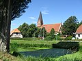
- The Gothic , three-aisled village church Steffen Hagen is a hall church from brick . The choir is from the end of the 13th century. The building was partially expanded in the second half of the 19th century, and the historicizing tower also dates from this time. Inside the church there is a carved altar from the second half of the 15th century, a pulpit from the 18th century, a triumphal cross group from the 14th century and a Romanesque granite baptism.
- Former school building in Niedersteffenshagen

church
Center of Steffenshagen

Post mill in Steffenshagen
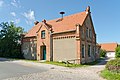
Old school in Niedersteffenshagen

Cobblestone street in Steffenshagen

Draw well


Individual evidence
- ↑ Statistisches Amt MV - population status of the districts, offices and municipalities 2019 (XLS file) (official population figures in the update of the 2011 census) ( help ).
Web links

Admannshagen-Bargeshagen | Old Bukow | Alt Sührkow | Altkalen | Am Salzhaff | Bad Doberan | Bartenshagen-Parkentin | Bastorf | Baumgarten | Behren-Lübchin | Benitz | Bentwisch | Bernitt | Biendorf | Blankenhagen | Börgerende-Rethwisch | Bröbberow | Broderstorf | Bützow | Cammin | Carinerland | Dahmen | Dalkendorf | Dobbin-Linstow | Dolgen am See | Dreetz | Dummerstorf | Elmenhorst / Lichtenhagen | Finkenthal | Gelbensande | Glasewitz | Gnewitz | Gnoien | Graal-Müritz | Grammow | Great Roge | Groß Schwiesow | Big wokers | Groß Wüstenfelde | Gülzow-Prüzen | Guestrow | Gutow | High demzin | Hohen Sprenz | Hohenfelde | Hoppenrade | Jördenstorf | Juergenshagen | Kassow | Klein Belitz | Klein Upahl | Krakow am See | Kritzmow | Kröpelin | Kuchel miss | Kühlungsborn | Cow | Laage | Lalendorf | Lambrechtshagen | Lelkendorf | Wages | Lüssow | Mistorf | Mönchhagen | Mühl Rosin | Neubukow | Nienhagen | Nustrow | Papendorf | Penzin | Plaaz | Pölchow | Poppendorf | Prebberede | Reddelich | Reimershagen | Rerik | Retschow | Rye | Rövershagen | Rühn | Rukieten | Sanitz | Sarmstorf | Satow | Schorssow | Swaan | Schwasdorf | Selpin | Stäbelow | Steffenshagen | Steinhagen | Stubbendorf | Sukow-Levitzow | Tarnow | Ticino | Teterow | Thelkow | Thulendorf | Thürkow | Vorbeck | Walkendorf | Wardow | Warnkenhagen | Warnow | Wiendorf | Wittenbeck | Zarnewanz | Zehna | Zepelin | Ziesendorf