
Biendorf (Mecklenburg)
| coat of arms | Germany map | |
|---|---|---|

|
Coordinates: 54 ° 5 ' N , 11 ° 42' E |
|
| Basic data | ||
| State : | Mecklenburg-Western Pomerania | |
| County : | Rostock | |
| Office : | Neubukow-Salzhaff | |
| Height : | 48 m above sea level NHN | |
| Area : | 40.88 km 2 | |
| Residents: | 1205 (Dec. 31, 2019) | |
| Population density : | 29 inhabitants per km 2 | |
| Postal code : | 18230 | |
| Primaries : | 038292, 038294 | |
| License plate : | LRO, BÜZ, DBR, GÜ, ROS, TET | |
| Community key : | 13 0 72 014 | |
| Office administration address: | Panzower Landweg 1 18233 Neubukow |
|
| Website : | ||
| Mayoress : | Peggy Freyler | |
| Location of the municipality of Biendorf in the Rostock district | ||
  |
||

Biendorf is a municipality in the Rostock district in Mecklenburg-Western Pomerania (Germany). It is administered by the Neubukow-Salzhaff office based in the city of Neubukow .
geography
The municipality of Biendorf is located between the four cities of Neubukow, Kröpelin , Kühlungsborn and Rerik, about 10 km from the Baltic Sea coast in the north and from Salzhaff in the west. The municipality is located at an average height of 30 m above sea level. To the south of the village of Biendorf is the approx. 6 hectare lake Neues Torfmoor . The Hellbach flows through the villages of Jörnstorf and Westenbrügge . In the municipality there are two larger forest areas, the Biendorfer Tannen with 156 ha and east of West Bruges the West Bruges Wood with approx. 200 ha.
Districts
The districts of Biendorf, Büttelkow, Gersdorf, Dorf Jörnstorf, Hof Jörnstorf , Körchow, Lehnenhof, Parchow, Sandhagen, Uhlenbrook, Westenbrügge and Wischuer belong to the municipality of Biendorf .
history
Incorporations
Wischuer was incorporated into Büttelkow on July 1, 1950. Büttelkow, Gersdorf and Sandhagen formed the new municipality of Biendorf on September 8, 1966. Jörnstorf has been part of Biendorf since July 1st, 1998. West Bruges was incorporated on June 13, 2004.
History of the districts
Hof Jörnstorf was first mentioned in a document in 1219 when it came into the possession of Sonnenkamp Monastery as villa jordanis (house of a Jordan knight) .
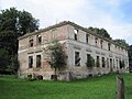
Parchow was owned by a monastery from 1211 to 1219. The later property belonged u. a. the families von Herzberg (before 1782), von Bassewitz (1787), von Plessen (1803–1812), Warnke (1821–1840) and von Storch (1816–1945); then managed by the LPG until 1991 . The two-storey, nine-axle manor house is in ruins.
West Bruges was founded as a German eastern settlement and was first mentioned in a document in 1318. A bridge over the Hellbach stands for the name. The late Gothic brick church in Westenbrügge dates from the 14th century; the classicist mansion from 1696.
politics
Community representation
The municipal council consists of 10 members. The election to the local council on June 7, 2009 had the following results:
| Party / applicant | percent | Seats |
|---|---|---|
| Groups of voters | 90.5 | 9 |
| Individual applicants | 9.5 | 1 |
Attractions
- The Gothic village church of Biendorf is a flat-roofed field stone building using brick from 1300 with a rectangular choir and a boarded tower. The pulpit dates from 1665. 1907 and from 2002 the church was extensively renovated.
- A pastor was first mentioned around 1324. Biendorf had been in the possession of the Schwerin Cathedral Chapter since the 13th century and from 1550 the church was under the patronage of the State of Mecklenburg . From 1770 to 1773 the parish Biendorf belonged to Russow, from 1777 to 1850 to Brunshaupten, today part of Kühlungsborn . In June 1776 the parish buildings burned down and all church records were lost.
- The late Gothic, single-nave church of Westenbrügge made of brick has a three-bay , cross-ribbed nave and a choir with a five-eighth end .
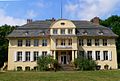
- The manor house Büttelkow is a two-storey, eleven- axis plastered building with a three-storey central risalit and mansard roof , it was built in 1912 according to plans by Paul Korff .
- The Körchow mansion was built in 1822 according to plans by Carl Theodor Severin as a single-storey plastered building with a mansard roof in the Empire style. Several modifications followed. The estate was owned by the von Bülow , Danner, von Boye (1753–1775), von Bülow and Lent (1932–1945) families . After 1945 it served as a residential building, after 1990 it came into private ownership and was renovated.
- Neo-Gothic manor house in Gersdorf, built in 1868
- Lehnenhof mansion with park, built 1912–1913 based on a design by Paul Korff
- Ruins of the Parchow mansion
- Classicist mansion in Westenbrügge, built around 1840

Biendorf village church

West Bruges Church
Manor house Büttelkow
Ruins of the Parchow mansion


traffic

The federal highway 105 and the Rostock – Wismar railway line with the Sandhagen stop run through the municipality .
Personalities
- Adolph Friedrich Johann Riedel (1809–1872), archivist, historian and politician, was born on December 5, 1809 in Biendorf as the son of pastor Johann Christian Conrad Riedel and his wife Amalia Maria Caroline (née Joergens). He died in Berlin on September 8, 1872.
- Helmuth Johannes Ludwig von Moltke (1848–1916), Prussian general, chief of the General Staff
literature
- Friedrich Schlie : The art and history monuments of the Grand Duchy of Mecklenburg-Schwerin . The district court districts of Hagenow, Wittenburg, Boizenburg, Lübenheen, Dömitz, Grabow, Ludwigslust, Neustadt, Crivitz, Brüel, Warin, Neubukow, Kröpelin and Doberan. III. Tape. Schwerin 1899, p. 533-536 ( digitized from the Internet Archive [accessed July 29, 2015]).
Web links
Individual evidence
- ↑ Statistisches Amt MV - population status of the districts, offices and municipalities 2019 (XLS file) (official population figures in the update of the 2011 census) ( help ).
- ↑ a b Federal Statistical Office (ed.): Municipalities 1994 and their changes since 01.01.1948 in the new federal states . Metzler-Poeschel, Stuttgart 1995, ISBN 3-8246-0321-7 .
- ↑ Area changes in Mecklenburg-Western Pomerania from 1990 to 1999. (PDF; 71 kB) Statistical Office Mecklenburg-Western Pomerania, January 12, 2005, p. 14 , accessed on July 29, 2015 .
- ↑ Area changes in Mecklenburg-Western Pomerania 2004 (PDF; 61 kB) Statistical Office Mecklenburg-Western Pomerania, February 28, 2005, p. 8 , accessed on July 29, 2015 .
- ↑ The election results of the regional returning officer on the website of the Statistical Office (PDF; 1.2 MB)

Admannshagen-Bargeshagen | Old Bukow | Alt Sührkow | Altkalen | Am Salzhaff | Bad Doberan | Bartenshagen-Parkentin | Bastorf | Baumgarten | Behren-Lübchin | Benitz | Bentwisch | Bernitt | Biendorf | Blankenhagen | Börgerende-Rethwisch | Bröbberow | Broderstorf | Bützow | Cammin | Carinerland | Dahmen | Dalkendorf | Dobbin-Linstow | Dolgen am See | Dreetz | Dummerstorf | Elmenhorst / Lichtenhagen | Finkenthal | Gelbensande | Glasewitz | Gnewitz | Gnoien | Graal-Müritz | Grammow | Great Roge | Groß Schwiesow | Big wokers | Groß Wüstenfelde | Gülzow-Prüzen | Guestrow | Gutow | High demzin | Hohen Sprenz | Hohenfelde | Hoppenrade | Jördenstorf | Juergenshagen | Kassow | Klein Belitz | Klein Upahl | Krakow am See | Kritzmow | Kröpelin | Kuchel miss | Kühlungsborn | Cow | Laage | Lalendorf | Lambrechtshagen | Lelkendorf | Wages | Lüssow | Mistorf | Mönchhagen | Mühl Rosin | Neubukow | Nienhagen | Nustrow | Papendorf | Penzin | Plaaz | Pölchow | Poppendorf | Prebberede | Reddelich | Reimershagen | Rerik | Retschow | Rye | Rövershagen | Rühn | Rukieten | Sanitz | Sarmstorf | Satow | Schorssow | Swaan | Schwasdorf | Selpin | Stäbelow | Steffenshagen | Steinhagen | Stubbendorf | Sukow-Levitzow | Tarnow | Ticino | Teterow | Thelkow | Thulendorf | Thürkow | Vorbeck | Walkendorf | Wardow | Warnkenhagen | Warnow | Wiendorf | Wittenbeck | Zarnewanz | Zehna | Zepelin | Ziesendorf