Stäbelow
| coat of arms | Germany map | |
|---|---|---|

|
Coordinates: 54 ° 2 ′ N , 12 ° 1 ′ E |
|
| Basic data | ||
| State : | Mecklenburg-Western Pomerania | |
| County : | Rostock | |
| Office : | Warnow-West | |
| Height : | 30 m above sea level NHN | |
| Area : | 14.99 km 2 | |
| Residents: | 1404 (Dec. 31, 2019) | |
| Population density : | 94 inhabitants per km 2 | |
| Postal code : | 18198 | |
| Area code : | 038207 | |
| License plate : | LRO, BÜZ, DBR, GÜ, ROS, TET | |
| Community key : | 13 0 72 098 | |
| LOCODE : | DE SBW | |
| Office administration address: | Schulweg 1a 18198 Kritzmow |
|
| Website : | ||
| Mayor : | Hans-Werner Bull (WG GfGS) | |
| Location of the municipality of Stäbelow in the Rostock district | ||
Stäbelow is a municipality in the Rostock district in Mecklenburg-Western Pomerania ( Germany ). The community is administered by the Warnow-West office with its seat in Kritzmow . Stäbelow, Bliesekow and Wilsen belong to the municipality of Stäbelow.
Due to its proximity to the port and Hanseatic city of Rostock , the community has become one of the preferred residential locations for Rostock residents. The population increased in the years after 1990 from 547 (December 31, 1990) to 1,373 (December 31, 2007). Four new housing estates have been built in Stäbelow since 1990.
geography
The municipality of Stäbelows is located southwest of Rostock on both sides of the Waidbach , which flows in a southerly direction and flows into the Beke near Matersen . To the southeast, about seven kilometers away, the Warnow flows past the municipality.
Stäbelow is surrounded by the neighboring communities Lambrechtshagen in the north, Kritzmow in the east, Ziesendorf in the south, Satow in the southwest and Bartenshagen-Parkentin in the northwest.
To the south of Stäbelow is the Driveholzer Forest conservation area . Many endangered animal and plant species are at home here.
history
The farming villages of Stäbelow and Wilsen were founded in 1177. Bliesekow was first mentioned in a document in 1268. The Stäbelow village church from the beginning of the 14th century was built in the Gothic style.
On July 1, 1950, the previously independent municipality of Bliesekow was incorporated.
Since the political change in 1990, the character of the community has changed significantly. Many homes were built in the “Lütt Eck”, “Grot Eck”, “Lang Berg” and “Waldblick” residential areas. More than 50 commercial enterprises are based in the municipality.
politics
Municipal council and mayor
The municipal council (including the mayor) consists of 10 members. The election for municipal council on May 26, 2019 had the following results:
| Party / applicant | percent | Seats |
|---|---|---|
| The left | 31.5 | 3 |
| Shared flat for the community of Stäbelow | 28.7 | 3 |
| CDU | 27.5 | 3 |
| SPD | 11.8 | 1 |
The mayor of the community is Hans-Werner Bull (shared flat for the community of Stäbelow). He was elected with 50.5% of the vote.
coat of arms
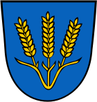
Blazon : "In blue, three fanned-out golden ears of corn that have grown together."
The coat of arms was handed over to the mayor for the municipality in 2003 by the district administrator. The three ears of wheat symbolize the togetherness of the three places in the community. They indicate the agricultural character of the villages.
Attractions
→ See also the list of architectural monuments in Stäbelow
- The Gothic , single-nave brick village church on a field stone base with a low-set cross-ribbed vault and each with a stepped buttress dates from the beginning of the 14th century. On the north side the rib vaulted sacristy . The square tower with its four front gables has an eight-sided tower spire .
Transport links
The municipality is located on the federal highway 103 (formerly B 103n), which was completed in 2003 , the motorway feeder to the Rostock-West junction of the Baltic A 20 motorway .
There is a very good bus connection to and from Rostock through the regional coast service .
Individual evidence
- ↑ Statistisches Amt MV - population status of the districts, offices and municipalities 2019 (XLS file) (official population figures in the update of the 2011 census) ( help ).
- ↑ Results of the election of the community representatives to the Zweckverband Kommunale Datenverarbeitung Oldenburg (KDO)
- ↑ Results of the mayoral election at Zweckverband Kommunale Datenverarbeitung Oldenburg (KDO)


