Beke (Warnow)
| Beke | ||
|
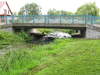
Road bridge over the Beke in Schwaan |
||
| Data | ||
| Water code | DE : 9648 | |
| location | Germany : Mecklenburg-Western Pomerania | |
| River system | Warnow | |
| River basin district | Warnow / Peene | |
| source | Northern end of the silted up Neukirchener See 53 ° 55 ′ 44 ″ N , 11 ° 56 ′ 48 ″ E |
|
| Source height | 6.1 m above sea level HN | |
| muzzle | in Schwaan in the Warnow Coordinates: 53 ° 56 '32 " N , 12 ° 6' 38" E 53 ° 56 '32 " N , 12 ° 6' 38" E |
|
| Mouth height | 0.2 m above sea level HN | |
| Height difference | 5.9 m | |
| Bottom slope | approx. 0.28 ‰ | |
| length | approx. 21 km | |
| Catchment area | 313 km² | |
| Discharge at the level Bröbberow A Eo : 312 km² Location: 6 km above the mouth |
NNQ (often) MNQ 1975–2005 MQ 1975–2005 Mq 1975–2005 MHQ 1975–2005 HHQ (03/06/1979) |
0 l / s 229 l / s 1.91 m³ / s 6.1 l / (s km²) 11.3 m³ / s 21.9 m³ / s |
| Left tributaries | Waidbach , Kleine Beke | |
| Small towns | Swaan | |
The Beke is a left tributary of the Warnow in the Rostock district of Mecklenburg-Western Pomerania .
description
The source of the Beke is on the northern edge of the silted up Neukirchener See . This wetland is fed by ditches from the south. The Kleine Beke joins the Beke from the left near Reinstorf . On the way to the northeast, it passes the villages of Klein Belitz and Groß Belitz. The Waidbach flows into the Beke south of a forest around the Dachsberg . From there it takes an easterly direction. Between Bröbberow and Groß Grenz, the river runs in a south-easterly direction. After crossing the western districts of Schwaan , the Beke flows into the Warnow north of the city center.
Individual evidence
- ^ German Hydrological Yearbook Coastal Area of the Baltic Sea 2005. (PDF) State Office for Environment and Nature Mecklenburg-Western Pomerania, accessed on October 4, 2017 (German, at: dgj.de).
Web links
Commons : Beke (Warnow) - Collection of images, videos and audio files
