
Reimershagen
| coat of arms | Germany map | |
|---|---|---|

|
Coordinates: 53 ° 40 ′ N , 12 ° 11 ′ E |
|
| Basic data | ||
| State : | Mecklenburg-Western Pomerania | |
| County : | Rostock | |
| Office : | Guestrow Land | |
| Height : | 70 m above sea level NHN | |
| Area : | 32.25 km 2 | |
| Residents: | 404 (December 31, 2019) | |
| Population density : | 13 inhabitants per km 2 | |
| Postal code : | 18276 | |
| Area code : | 038457 | |
| License plate : | LRO, BÜZ, DBR, GÜ, ROS, TET | |
| Community key : | 13 0 72 084 | |
| Office administration address: | Haselstrasse 4 18273 Güstrow |
|
| Website : | ||
| Mayor : | Jens Kupfer | |
| Location of the municipality of Reimershagen in the Rostock district | ||
  |
||

Reimershagen is a municipality in the south of the Rostock district in Mecklenburg-Western Pomerania (Germany). It is administered by the Güstrow-Land Office , based in the non-official city of Güstrow .
geography
The municipality of Reimershagen in the Mecklenburg Lake District northwest of the Krakower See is located in an area rich in forests, hills and lakes. The area around the community reaches heights of about 80 m above sea level. NN. The closest cities are Krakow am See , Goldberg and Güstrow. In the south, the community has a share in the Nossentiner / Schwinzer Heide nature reserve . The Bresenitz rises southwest of the outskirts of Reimershagen , and the Reimershagener See lies to the east.
Reimershagen is surrounded by the neighboring communities of Zehna in the north, Krakow am See in the east, Dobbertin in the south and Lohmen in the west.
The districts of Groß Tessin, Hohen Tutow, Kirch Kogel , Rum Kogel and Suckwitz belong to Reimershagen .
history
The village of Reimershagen, laid out as a round , first appeared in a document in 1303. The area was already settled in the Bronze Age, as indicated by megalithic graves in a forest northeast of the Reimershagener See.
Located on the village road in Reimershagen, on all sides surrounded by gardens, settlement houses in brick / half-timbered construction with pitched roofs, probably 1930 from the 1920 / years. They have the character of a model settlement. With the gable side - adorned by wooden horse heads - facing the street, there is the front living area, behind it the business section in the same house. In many houses, this has now also been converted for residential purposes. The settlement houses all had individual names, some are still preserved and recognizable.
Attractions
Kirch Kogel
- Early Gothic stone church by Kirch Kogel from the 13th century.
- Former manor house as a single-storey, 13-axis clinker brick building from 1840 with a two-storey central risalit and a crooked hip roof , which used to house a youth, cultural and environmental education center.
Greater Ticino
- Old Forge
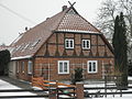
Settlement house in Reimershagen

Church in Kirch Kogel
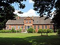
Former manor house in Kirch Kogel


traffic
A little off the national traffic lines, Reimershagen is connected to the surrounding cities by roads. The federal motorway 19 ( Berlin - Rostock ) is about 14 kilometers away (connection Krakow ). The next train station for passenger traffic is in the district town of Güstrow, 20 kilometers away.
European hiking trails 9a and 10 intersect in the municipality .
Web links
Individual evidence
- ↑ Statistisches Amt MV - population status of the districts, offices and municipalities 2019 (XLS file) (official population figures in the update of the 2011 census) ( help ).

Admannshagen-Bargeshagen | Old Bukow | Alt Sührkow | Altkalen | Am Salzhaff | Bad Doberan | Bartenshagen-Parkentin | Bastorf | Baumgarten | Behren-Lübchin | Benitz | Bentwisch | Bernitt | Biendorf | Blankenhagen | Börgerende-Rethwisch | Bröbberow | Broderstorf | Bützow | Cammin | Carinerland | Dahmen | Dalkendorf | Dobbin-Linstow | Dolgen am See | Dreetz | Dummerstorf | Elmenhorst / Lichtenhagen | Finkenthal | Gelbensande | Glasewitz | Gnewitz | Gnoien | Graal-Müritz | Grammow | Great Roge | Groß Schwiesow | Big wokers | Groß Wüstenfelde | Gülzow-Prüzen | Guestrow | Gutow | High demzin | Hohen Sprenz | Hohenfelde | Hoppenrade | Jördenstorf | Juergenshagen | Kassow | Klein Belitz | Klein Upahl | Krakow am See | Kritzmow | Kröpelin | Kuchel miss | Kühlungsborn | Cow | Laage | Lalendorf | Lambrechtshagen | Lelkendorf | Wages | Lüssow | Mistorf | Mönchhagen | Mühl Rosin | Neubukow | Nienhagen | Nustrow | Papendorf | Penzin | Plaaz | Pölchow | Poppendorf | Prebberede | Reddelich | Reimershagen | Rerik | Retschow | Rye | Rövershagen | Rühn | Rukieten | Sanitz | Sarmstorf | Satow | Schorssow | Swaan | Schwasdorf | Selpin | Stäbelow | Steffenshagen | Steinhagen | Stubbendorf | Sukow-Levitzow | Tarnow | Ticino | Teterow | Thelkow | Thulendorf | Thürkow | Vorbeck | Walkendorf | Wardow | Warnkenhagen | Warnow | Wiendorf | Wittenbeck | Zarnewanz | Zehna | Zepelin | Ziesendorf