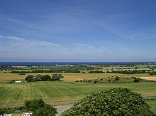
Cooling (mountain range)
The cooling is up to 129.8 m above sea level. NHN high, partly wooded ridge in Mecklenburg-Western Pomerania west and south of Bad Doberan . The name is derived from the word "Kuhlen", referring to a strongly rugged northern slope with small valleys and depressions . Large parts are protected landscape areas .
Geographical location and landscape
The cooling system is located in the Rostock district, southeast of the Mecklenburg Bay and south of the Baltic Sea coast . It is part of the Baltic ridge that stretches along the coast from Ostholstein . The ridge is around 23 km long and up to 8 km wide and stretches from the steep coast north of Rerik in the northwest to Hanstorf in the southeast. Geologically, it is a compression moraine . It consists of two parts, the Diedrichshagener mountains in the northwest and the Ivendorfer heights in the southeast. Originally the name “cooling” only referred to the forest slope on the north side of the Diedrichshagener Berge, which is jagged by valleys and depressions . From this it went over to the ridge of the Diedrichshagener Berge and is better known in this meaning than in the sense in which it is used in geosciences and administration. A little over half of the ridge is covered with fields and grassland. The forests are mostly mixed forest with a high proportion of beeches , but also some oaks .
Diedrichshagen mountains
The Diedrichshagener Berge and thus the cooling in the colloquial sense are eleven kilometers long and two to three kilometers wide. You start with the 78.8 m high Bastorfer Signalberg, on which the Bastorf lighthouse is visible from afar , and reach almost 130 m above sea level on Diedrichshagener Berg . NHN . On the northern slope of the Diedrichshagener Berge there is a continuous strip of forest that is between 500 meters and one kilometer wide and covers a total area of 6300 hectares. The high ridge ends near Kröpelin . In the Kröpeliner depression with the peat bog (here also a proper name) the top of the cooling is only 73 m above sea level. NHN .
Ivendorfer Heights
The Ivendorfer Heights are a high plateau up to eight kilometers wide east of the Kröpeliner Senke, which in three places over 100 m above sea level. NHN and has veritable slopes and incised valleys on the northeast flank, especially in the Hütter Wohld near Parkentin . In addition to this, there are also forests on the high plateau, some of which are former high moors .
geology
The hilly hilly landscape of the cooling was created during the last great ice age . It belongs to the main terminal moraine of the Pomeranian stage of the Vistula glaciation (approx. 15,600 years ago) and at the same time forms the edge of the ice of another glacier advance of this stage. Because the ice layer from the later glaciation was no longer so thick and heavy that it could have overcome the old terminal moraine, rock material was pushed up from the bottom of the glacier from sometimes greater distances and deposited on the old terminal moraine. This is how a distinctive compression moraine was created here . In its relief, the cooling is more like a miniaturized low mountain range. There are extremely narrow valleys and steep climbs that are otherwise hardly usual for the terminal moraines of the Baltic ridge. The eponymous hollows were created by slowly melting old ice blocks. Some boulders still point to the "icy transport" of rock material.
Cultural monuments and tourism
There are many large stone graves in the hilly landscape and in its surroundings, which indicate an early settlement. There are passage and barrow graves , large and ancient dolmen from the Neolithic Age , which date from around 4000 to 3000 BC. Were erected.
The numerous hiking and biking trails offer good prospects at various points - including the Baltic Sea. You pass interesting natural monuments, such as graves and boulders. There are also a few mansions , neo-Gothic buildings, Art Nouveau villas and parks.
Surveys
Some of the “mountain” parts of the cooling system are actually just hill ledges. In contrast, some vertices are nameless. In the list, the altitude values in meters (m) above mean sea level, unless otherwise stated, come from:
|
|
places
- Kühlungsborn - in the north
- Bad Doberan - in the east
- Kröpelin - in the south
- Rerik - in the west
natural reserve
Large parts of the ridge belong to the 12,800 hectare conservation area cooling . Only the southeastern part of the ridge around Retschow and Hanstorf does not belong to the landscape protection area.
References and comments
- ↑ a b Geodata Viewer of the Office for Geoinformation, Surveying and Cadastral Affairs Mecklenburg-Western Pomerania ( notes )
- ↑ Geoportal MV → Home / Home → Historical Maps → Historical Maps (University of Rostock) → 1st point = Schmettau 1788 or 3rd point = measuring table sheet from 1888
- ^ Neubrandenburg Geological Contributions, Heft 5 (2007), pp. 42–47: Ulrich Müller: The cooling, an ice age phenomenon
- ↑ Map of the natural structure of the landscape framework plan Central Mecklenburg / Rostock (UM MV 2003) (PDF)
- ↑ The 110.3 m are in the DTK25 (but without naming their names)
- ↑ a b c elevation according to unknown / not researched source
- ↑ State Office for the Environment, Nature Conservation and Geology: Landscape Protection Areas in Mecklenburg-Western Pomerania, status December 31, 2012 , (PDF) , accessed on December 6, 2013
Web links
Coordinates: 54 ° 5 ' N , 11 ° 48' E


