Stoltera

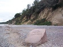
The Stoltera [ ʃtɔlterɑː ], also Stolteraa , is about three kilometers long section of the Baltic Sea in the state of Mecklenburg-Vorpommern , the west of Warnemünde starts and runs from there in a westerly direction until the Geinitzort, which according to the German geologists and mineralogist Eugen Geinitz named is. The coastal strip covers an area of around 70 hectares and is characterized by a steeply sloping cliff up to 20 meters high towards the Baltic Sea. In much of the area as is the nature reserve Stoltera under conservation .
From a geomorphological point of view, the steep coast of the Stoltera is shaped by both glacial deposits and erosion processes. The natural area mainly includes a coastal forest of red and hornbeams , English oaks and red oaks , birches and chestnuts . The cliff is home to sand martins and various species of beetles . The Stoltera is made accessible to tourism by a coastal footpath and two nature trails with astronomical and natural history topics . The Baltic Sea Cycle Route also runs through the Stoltera.
There are various explanations for the name “Stoltera”. Friedrich Barnewitz leads the name back to "Stolter Ort", whereby the word "Ort" means "Landspitze" ; “Stolter” can come from the Low German word for “steep”. According to Barnewitz, vacationers would have interpreted the indistinct pronunciation of the locals as "Stoltera". Another theory leads the name back to the personal name “Stolter” and the old word “Aa” for “Bach”.
Various ships were baptized in the name of this landscape, for example the cargo ship MS Stoltera of the Deutsche Seereederei Rostock and two rescue boats of the GDR's sea rescue service . A city express operated by the Deutsche Reichsbahn , which ran between Rostock and Berlin from 1976 to 1991 , also bore this name.
literature
- Franz Eugen Geinitz: The Stoltera near Warnemünde. Print by Adler's heirs, Rostock 1907
Web links
Individual evidence
- ^ Friedrich Barnewitz , History of the Port of Warnemünde , Leopold, Rostock 1925, p. 46.
- ^ Rostock's street names from A – Z , Rostock City Archives, Rostock 1981, p. 81.
Coordinates: 54 ° 10 ′ 39.8 ″ N , 12 ° 0 ′ 43 ″ E


