
Drawsko Pomorskie
| Drawsko Pomorskie | |||
|---|---|---|---|

|
|
||
| Basic data | |||
| State : | Poland | ||
| Voivodeship : | West Pomerania | ||
| Powiat : | Drawsko Pomorskie | ||
| Area : | 22.00 km² | ||
| Geographic location : | 53 ° 32 ' N , 15 ° 48' E | ||
| Residents : | 11,597 (Jun. 30, 2019) |
||
| Postal code : | 78-500 | ||
| Telephone code : | (+48) 94 | ||
| License plate : | ZDR | ||
| Economy and Transport | |||
| Street : | DK20 Stargard ↔ Gdynia | ||
| Ext. 148 Starogard Łobeski ↔ Drawsko Pomorskie | |||
| Ext. 175 Drawsko Pomorskie ↔ Choszczno | |||
| Rail route : | PKP line No. 210: Chojnice – Runowo Pomorskie railway line | ||
| Next international airport : | Szczecin-Goleniów | ||
| Gmina | |||
| Gminatype: | Urban and rural municipality | ||
| Gmina structure: | 32 localities | ||
| 13 school authorities | |||
| Surface: | 344.00 km² | ||
| Residents: | 17,270 (June 30, 2019) |
||
| Population density : | 50 inhabitants / km² | ||
| Community number ( GUS ): | 3203023 | ||
| Administration (as of 2014) | |||
| Mayor : | Zbigniew Ptak | ||
| Address: | ul. Gen. Wł. Sikorskiego 41 78-500 Drawsko Pomorskie |
||
| Website : | www.drawsko.pl | ||

Drawsko Pomorskie ( German : Dramburg ) is a district town and urban and rural municipality in the Polish West Pomeranian Voivodeship with about 12,000 inhabitants.
Geographical location
The city is located in Pomerania in Pomerania Switzerland in the area of the Pomeranian ridge , at an altitude of 97 m above sea level, and is touched by the upper reaches of the Drawa river (Drage) . A large forest area extends to the east. South of the city is the Jezioro Okra (Wuckersee) . Szczecin in the west is about 100 km away.
In the south of the city is Europe's largest military training area, Centrum Szkolenia Wojsk Lądowych Drawsko (Poligon Drawsko), used by Polish and NATO troops. The military training area and the vicinity of Drawsko are also regular venues for the Wroclaw Rally .
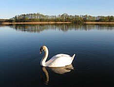
Jezioro okra

Bridge over the Drage River (1930)


City history


From the 7th to the 13th century there was a Slavic fortification on the upper reaches of the Drage river, a few kilometers north of the Lübbe lake . After the Brandenburg electors had acquired the territory of Poland in the middle of the 13th century, they commissioned Belbuck monks to found a monastery in 1254 as part of their settlement efforts . The plans failed, however, as the intended location was too far from the parent monastery and the monks found the land unsuitable because of its wilderness. The Brandenburgers stuck to their plans, however, and since a settlement had developed near the castle, the Prenzlau knights Arnold, Konrad and Johann von Golz were commissioned by the margraves to develop the place into a city. By settling German immigrants, they succeeded in expanding the village to such an extent that in 1297 the Brandenburg margraves Otto IV "with the arrow" and Conrad I and his sons were able to grant Magdeburg city rights . In order to further promote the development of the city, Margrave Ludwig I waived all taxes from 1338 to 1350. In 1350 the town was given to the von Wedell family as a fief. On February 13, 1368, Dramburg was the scene of the peace treaty between the Brandenburg margrave Otto the Finner and the Polish king Casimir III. Meanwhile the influx of settlers continued, so that at the end of the 14th century the Dramburger Neustadt developed on the southern bank of the Drage. In 1400, Margrave Sigismund (later Emperor Sigismund ) sold the city together with the entire Neumark to the Teutonic Order , which, however, only ruled until 1455.
The Franciscan order maintained the Dramburg monastery from the 14th to the 16th century.
The former Franciscan Faustinus Schliepe, who converted in 1537, introduced the Reformation in Dramburg in the same year . From 1540 the Order of St. John was the owner of the city and remained so until 1808. A great fire destroyed large parts of the city in 1620, only five houses remained intact. Five years later, numerous residents fell victim to the plague . During the Thirty Years War in 1638 the Swedish Colonel Beer attacked the city with looting and pillage. Despite these catastrophes, Dramburg's economy did not suffer any major damage. The city had the right to staple the Kolberg salt, which was transported on the drage, wool weavers and Schumacher were the determining trades at the end of the Middle Ages.
When, after the end of the Wars of Liberation, Prussia reorganized its territorial administration, Dramburg was elevated to the status of the district town of the district of the same name in the Pomeranian administrative district of Köslin in 1818 . The Pomeranian Central Railway reached the city in 1877, which was also connected to the Saatzig small railway network in 1896 . As a result, several industrial companies in the wood and textile industry settled. The establishment of the main station of the Pomeranian Saatzucht Gesellschaft, which operated its experimental fields in Dramburg, had a positive effect.
After the First World War , when many residents moved from the area of the Polish Corridor established by the provisions of the Versailles Treaty in 1920 , Dramburg expanded to include new residential areas in the south of the city. After the dissolution of the Grenzmark Posen-West Prussia province in 1938, Dramburg became part of the Schneidemühl administrative district . During the Second World War , the SS ran a large motorcycle and mechanics school. Soviet and Polish troops captured the city on March 4, 1945, the city center of which was largely destroyed during the fighting.
After the end of the Second World War, Dramburg was placed under Polish administration by the Soviet occupying power in accordance with the Potsdam Agreement, together with the Pomerania region. Then began the immigration of Polish migrants, some of whom came from eastern Poland . As far as the native (German) townspeople had not fled, they were expelled from Dramburg by the local Polish administrative authority in the following period .
In 1950 the name was changed to Drawsko Pomorskie. Until 1975 the city was the administrative center of a powiat . After the administrative reform of 1999, this status was restored.
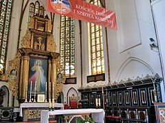
Altar of St. Mary

Elementary school with a tank memorial

Military training area


_near_Olezno,_Poland.jpg)
Demographics
| year | Residents | Remarks |
|---|---|---|
| 1719 | 757 | |
| 1750 | 1.312 | |
| 1801 | 1,558 | including three Jewish families with 38 individuals |
| 1816 | 1,808 | including eight Catholics and 49 Jews |
| 1831 | 2,667 | including seven Catholics and 87 Jews |
| 1843 | 3,413 | including three Catholics and 121 Jews |
| 1852 | 4,004 | including ten Catholics and 169 Jews |
| 1861 | 4,847 | including ten Catholics, 186 Jews and three members of the Free Congregation or German Catholics |
| 1875 | 5,626 | |
| 1880 | 6,049 | |
| 1890 | 5,923 | including 38 Catholics and 165 Jews |
| 1900 | 5,883 | mostly evangelicals |
| 1925 | 6,358 | |
| 1933 | 7,314 | |
| 1939 | 8.091 |
|

Town twinning
There are partnerships with the cities:
- Bad Bramstedt in Schleswig-Holstein , since 1999
- Strasburg in Mecklenburg-Western Pomerania , since 2004
- Falkenburg ( Złocieniec ) in the Polish West Pomeranian Voivodeship
Attractions

.jpg)
The most important architectural monument in the city is the late Gothic Church of the Resurrection ( kościół pw Zmartwychwstania Pańskiego ) from the 15th century, a three-aisled hall church made of brick. The story of the massive front tower is interesting. It has had an onion hood on a simple tent roof since the city fire of 1620 , lost this top in the 19th century and finally received its current pointed spire at the beginning of the 20th century. In the anteroom of the church (tower hall) there are two large stained glass windows with the family coat of arms v. Knebel-Doeberitz, v. Brockhausen, v. Griesheim, v. Zadow, v. Borcke and v. Grünberg. Until 1945, these were the most influential large landowners in the Dramburg district. The windows were donated by the families in 1914 on the occasion of the renovation of the tower hall. They were made in the W. Blaue workshop, Berlin-Dahlem. They were badly damaged by the effects of war. The restoration was carried out by the Polish master of glass painting Krzysztof Mazurkiewicz, Köslin.
In addition, the remains of the city wall from the 14th century, the market square with its partially preserved historical buildings and a half-timbered salt storage facility from around 1700 deserve attention.
traffic
.jpg)
Drawsko Pomorskie is located at Droga krajowa 20 (former German Reichsstrasse 158 ) Stargard - Gdynia . Furthermore, the provincial roads (DW) DW 148 to Starogard , DW 173 to Połczyn-Zdrój and DW 175 to Choszczno lead from the city .
The city is also connected to the Chojnice – Runowo Pomorskie line of the Polish State Railways (PKP) .
Personalities
sons and daughters of the town
- Rudolf Hiller von Gaertringen (1801–1866), German landowner and politician
- Emil Doerstling (1859–1940), German painter
- Gustav Bundt (1867–1949), German doctor, medical officer and politician (DNVP)
- Johannes Höffner (1868–1929), German writer and magazine editor
- Otto Pautsch (1873–1945), German teacher, district administrator in the Lebus district
- Cornelius Kutschke (1877–1968), German civil engineer, expert with the German peace delegation in Versailles
- Hanna Stephan (1902–1980), German writer
- Hans Stephan (1902–1973), German architect
- Fritz Manasse (1904–2006), German lawyer
- Ernst Moritz Manasse (1908–1997), German philosopher and classical philologist
- Hans Wolter (1911–1978), German physicist, professor at the University of Marburg
- Hans Ulrich Kempski (1922–2007), German journalist, chief correspondent for the Süddeutsche Zeitung
- Horst SAGES (1934–2014), German director, stage and costume designer
- Erhard Pachaly (1934–2012), German historian, professor at the University of the German People's Police
- Dieter Nerius (* 1935), German linguist
- Hans-Hermann Karl Engel (* 1936), German entrepreneur, developer of modern deep-sea fishing methods and fishing gear
- Harms Staecker (* 1936), German politician (CDU)
- Winfried Ulrich (* 1941), German Germanist and linguist
- Sybille Volkholz (* 1944), German politician (AL, Greens), former Senator for Education, Vocational Training and Sport in Berlin
Other personalities associated with the city
- August Froehlich (1891–1942), Roman Catholic priest , pastor in Rathenow, resistance fighter against the Nazi regime, died in Dachau concentration camp
Gmina Drawsko Pomorskie


The urban and rural municipality Drawsko Pomorskie covers an area of 344 km² and has more than 16,000 inhabitants.
The rural area of the municipality is divided into 18 school authorities , to which other localities are assigned:
- Borne (Born) , with Jutrosin (Morgenland) and Kolno (Steinbeck)
- Dalewo (Dalow)
- Dołgie (Dolgen) , with Grzybno (Charlottenhof) and Węglin (Sabinenhof)
- Gudowo (tree garden)
- Jankowo (Janikow) , with Kumki (Kümken) , Krzynno , Ustok (Heinrichsfelde) and Zbrojewo (Hohenheide)
- Jelenino (Annaberg) , with Szczytniki (Groß Schönberg)
- Konotop (Köhntöpf) , with Karwice (Karwitz) and Żołędowo (Mittelfelde)
- Łabędzie (Labenz)
- Linowno ( Woltersdorf )
- Mielenko Drawskie (Klein Mellen) , with Oleszno (Welschenburg) , Woliczno (Golz) and Ziemsko (Zamzow)
- Nętno (Nuthagen) , with Lasocin (Friedewald)
- Ostrowice (Wusterwitz) , with Donatowo (Dohnafelde)
- Przytoń (Pritten) , with Karpno (Karpen) , Kiełpin (Kölpin) , Przystanek (New Pritten) and Tęczyn
- Rydzewo (Rützow)
- Suliszewo (Zülshagen) , with Zagórki (Hünenberg)
- Zagozd (Neu Schönwalde) , with Cianowo (Jakobsdorf) , Gajewo and Gajewko (Eichforst)
- Zarańsko (Sarranzig) , with Roztoki (Wedellshof)
- Żółte (Shields) , with Olchowiec (Aalkist) and Żółcin (New Shields)
literature
- Gustav Kratz ; The cities of the province of Pomerania - an outline of their history, mostly according to documents . Berlin 1865, pp. 125–128 ( full text ).
- Friedrich Wilhelm August Bratring : Statistical-topographical description of the entire Mark Brandenburg. Volume 3: Containing the Neumark Brandenburg. Berlin 1809, pp. 223-225 ( books.google.de ).
- Paul van Niessen : The history of the city of Dramburg - Festschrift for the jubilee of its six hundred year existence . Jancke, Dramburg 1897 (reprint: Microson Reprints, 1994).
- Our Pommerland , vol. 13, vol. 11–12: District of Dramburg .
Web links
- Official website of the city (Polish, German, English)
- Website about the city (Polish)
- Website of the home group Dramburg in Pomerania
Individual evidence
- ↑ a b population. Size and Structure by Territorial Division. As of June 30, 2019. Główny Urząd Statystyczny (GUS) (PDF files; 0.99 MiB), accessed December 24, 2019 .
- ↑ Największy poligon w Europie
- ^ Heinrich Gottfried Philipp Gengler : Regesta and documents of the constitutional and legal history of the German cities in the Middle Ages , Erlangen 1863, p. 883 .
- ↑ a b c d e f g Gustav Kratz ; The cities of the province of Pomerania - an outline of their history, mostly according to documents . Berlin 1965, pp. 127–128 .
- ^ A b Friedrich Wilhelm August Bratring : Statistical-topographical description of the entire Mark Brandenburg. Volume 3: Containing the Neumark Brandenburg. Berlin 1809, p. 223 ( books.google.de ).
- ↑ a b c d e f g h i j Michael Rademacher: German administrative history from the unification of the empire in 1871 to the reunification in 1990. dramburg.html # ew39dramadramb. (Online material for the dissertation, Osnabrück 2006).
- ^ Meyer's Large Conversational Lexicon . 6th edition, Volume 5, Leipzig and Vienna 1906, p. 175.
- ↑ Drawsko Pomorskie: Współpraca z zagranicą [1]
- ^ Sołtysi i Rady Sołeckie Gminy Drawsko Pomorskie at Biuletyn Informacji Publiczne.

Urban and rural parishes: Czaplinek (Tempelburg) | Drawsko Pomorskie (Dramburg) | Kalisz Pomorski (Kallies) | Złocieniec (Falkenburg)
Rural municipality: Wierzchowo (Virchow)