Helpter mountains
| Helpter hill | ||
|---|---|---|
|
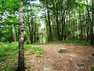
Summit Helpter Hill : Highest elevation of the Helpter Mountains |
||
| Highest peak | Helpter Berg ( 179.2 m above sea level ) | |
| location | District of Mecklenburg Lake District , Mecklenburg-Western Pomerania ( Germany ) | |
| part of | Backland of the Mecklenburg-Brandenburg Lake District | |
|
|
||
| Coordinates | 53 ° 29 ′ N , 13 ° 37 ′ E | |
| rock | Terminal moraine of the Vistula Ice Age | |
| particularities | - highest elevation in Mecklenburg-Western Pomerania - location of the Helpterberg telecommunications tower |
|
The Helpter Mountains in the Mecklenburg Lake District are 179.2 m above sea level. NHN the highest natural elevation in Mecklenburg-Western Pomerania and belong to the back country of the Mecklenburg-Brandenburg Lake District .
The terminal moraine , which originated in the Pomeranian phase of the Vistula Ice Age , was named after the town of Helpt , which is 2.4 km north-northwest . The wooded ridge is located in the east of the Mecklenburg Lake District, around 9 km west-southwest of Strasburg , around 3 km north-northeast of Woldegk and 2.5 km north-west of Mildenitz .
The ridge is part of a not very extensive range of hills that run from southwest to northeast. The Helpter , Mildenitzer and Woldegker Heide are in the landscape . To the south-west is the almost completely silted-up Große Totensee and beyond the Woldegk there, the Woldegker Stadtsee .
About 580 m southwest of the highest point of the Helpter Mountains, the 203.2 m high Helpterberg telecommunications tower has stood at about 151 m height since 1981 . Not far from there, further transmission systems were built in a north-northeast direction .

See also
Individual evidence
- ↑ Geodata viewer of the Office for Geoinformation, Surveying and Cadastre of Mecklenburg-Western Pomerania ( information )
Web links
- Brohmer & Helpter Berge - Website of the "Brohmer & Helpter Berge Tourismusverein eV"

