Drögeheide
|
Drögeheide
City of Torgelow
Coordinates: 53 ° 37 '5 " N , 14 ° 2' 9" E
|
|
|---|---|
| Postal code : | 17358 |
| Area code : | 03976 |
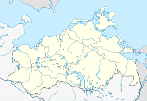
Location of Drögeheide in Mecklenburg-Western Pomerania |
Drögeheide is a housing estate in the town of Torgelow in Mecklenburg-Western Pomerania .
geography
Drögeheide is located southeast of the core town of Torgelow in the middle of the Ueckermünder Heide , between the rivers Uecker and Randow .
history
The name "Drögeheide" means dry heath in Low German . Until 1945, according to MTB (measuring table sheet) 1920–1945, it was only a forestry with a tar oven. It belonged to the Neuenkruger district. After 1952, this residential area was in the back of the later Jägerbrück combat shooting range and was removed.
In 1865 Drögeheide had 1 residential and 1 farm building, 9 residents in 1 family.
The Jägerbrück residential area belonging to the village was also part of the Neuenkruger district as a domain. The place had 1 Krughof, 1 tar oven, 1 forester's house, 1 fixed Randow bridge, 1 Randow lock with lock house and 4 Büdner positions in the Holländerei. In 1865 it had 8 residential and 18 farm buildings, 95 residents were resident in 19 families.
From 1952 new military buildings for the barracked people's police were built in the Ueckermünder Heide , including barracks in the forest south-east of Torgelow. The first work was carried out by a voluntary barracked labor service called Dienst für Deutschland . For the large shooting and practice range “Jägerbrück” the relatively large place of the same name with all facilities was pulled empty and then razed. From 1953 to 1956, the district of Drögeheide was built immediately to the northwest of the new barracks for around 1500 to 2000 professional soldiers and their families. With the founding of the East German NVA in 1956, these troops of the barracked people's police were transferred to the new army. A second construction phase took place between 1974 and 1976 with the construction of five-story prefabricated buildings, a high school, and social and utility facilities. The Jägerbrück military training and firing range belonging to the Drögeheide location was not only used by the NVA units in the area, but also by many NVA locations in the three northern districts of the GDR , as well as by the working class combat groups for group and train combat shooting with all types of weapons.
Until 1990, parts of the NVA's 9th Panzer Division were stationed in Drögeheide and used the Jägerbrück military training area to the southeast .
Today the firing range is used again by the Bundeswehr .
Like Spechtberg or Eggesin, Drögeheide has become synonymous with military service in the seclusion of the Ueckermünder Heide for tens of thousands of former conscripts . The numerous barracks, accommodation and social facilities for the professional soldiers ensured a high employment rate in the Torgelow area. All barracks from the NVA era were extensively modernized and served as accommodation for the stationed Bundeswehr members . In the course of the transformation of the Bundeswehr , the locations and barracks were closed except for Torgelow, Drögeheide and Viereck. The destruction of the NVA structures led to emigration and high unemployment.
Transport links
Drögeheide is on the road between Torgelow and Pasewalk . The former Drögeheide Nord stop was on the Pasewalk Ost-Gumnitz railway line, which was built for military purposes .
literature
- Heinrich Berghaus : Land book of the Duchy of Pomerania and the Principality of Rügen . Part II, Volume 1, Anklam 1865, p. 1007 ( online )
Individual evidence
- ^ Heinrich Berghaus : Land book of the Duchy of Pomerania and the Principality of Rügen . Part II, Volume 1, Anklam 1865, p. 1007 ( online )
