Chowra
| Chowra | ||
|---|---|---|
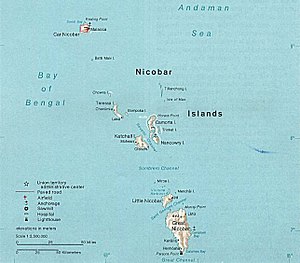
| Map of the Nicobar Islands - Chowra is located in the northwest of the central archipelago | ||
| Waters | Indian Ocean | |
| Archipelago | Nicobar Islands (Central Group) | |
| Geographical location | 8 ° 27 '15 " N , 93 ° 2' 45" E | |
|
|
||
| length | 2.5 km | |
| width | 2 km | |
| surface | 8.28 km² | |
| Highest elevation | 104.5 m | |
| Residents | 1336 (2001) 161 inhabitants / km² |
|
| main place | Sānēnya (Tahaila) | |
Chowra ( Nicobar : Sanenyo ) is an Indian island and one of the Nicobar Islands in the Indian Ocean .
It is located north of the neighboring island of Teressa . According to the 2001 Indian census, there were 1,336 people on the island, which were villages (before the tsunami): Tahaila , Rainion , Kuitasuk , Alhiat and Chongkamong ; all are on the east side of the island. The main village is Tahaila (Sānēnya) on the northeast coast. The island has an area of 8.28 km². It is flat, only in the south is a very steep rock up to 104.5 meters high.
The inhabitants of the island were respected as priests on the neighboring islands. They were carpenters and potters, making canoes and earthenware pots. They formed five clans with one leader. A coral reef protects the island, but it has no source of drinking water.
Of once a year, with the onset of monsoon , the "pig feast" ( Panuohonot ) and in May the "Chicken Fest" ( Kancheuollo ) celebrated.
In the great tidal waves of the tsunami as a result of the severe seaquake in the Indian Ocean in 2004 , Chowra was badly devastated.
Remarks
- ^ Page of the police with the island names ( memento of the original from March 27, 2010 in the Internet Archive ) Info: The archive link was automatically inserted and not yet checked. Please check the original and archive link according to the instructions and then remove this notice. (engl.)
- ^ Page of the police with the village name ( Memento of the original from May 25, 2011 in the Internet Archive ) Info: The archive link was inserted automatically and has not yet been checked. Please check the original and archive link according to the instructions and then remove this notice. (engl.)
- ↑ a b National Geospatial-Intelligence Agency: PUB. 173, Sailing Directions (Enroute): India and the Bay of Bengal, Bethesda, Maryland, Ninth Edition (PDF; 4.0 MB), p. 256
- ↑ Island-wise Statistical Outline - 2008. CHOWRA ISLAND ( page no longer available , search in web archives ) Info: The link was automatically marked as defective. Please check the link according to the instructions and then remove this notice. (PDF; English)
- ↑ http://www.india9.com/i9show/Chowra-21338.htm

