List of bridges in Berlin / H
Explanation
- (Sample bridge ) = in brackets : unnamed bridges.
- Sample bridge = in italics : former bridges. (See in detail: Structure of the lists )
| photography | Name of the bridge | District | Remarks | location |
|---|---|---|---|---|
|
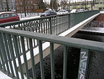
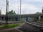
Halenseestrassenbrücken, also Halenseebrücken | Grunewald , Halensee | This name means several bridges: The two-part structure, which runs parallel to the A 100 on both sides , leads Halenseestrasse over the railway tracks. The eastern part of the bridge was completed in 1961, it is 67 m long and 17 m wide. The western part of the bridge is 59 m long and 15 m wide and was only inaugurated in 1967. Both parts are prestressed concrete structures . Both Halenseestrasse bridges have sidewalks and a steel railing on one side. In 2005 they were extensively renovated.
On the other hand, it is a railway bridge that leads over Halenseestrasse with the entrances and exits of the motorway (lower picture). The company Gregull und Spang was involved in the renovation work. |
cards |
 Belle Alliance Bridge 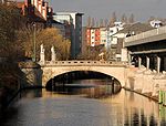
|
Hallesche Tor Bridge | Kreuzberg | The Hallesche Tor bridge at kilometer 6.1 of the canal crosses the Landwehr Canal at Hallesches Tor underground station . As a road bridge, it connects the riverside streets of Hallesches Ufer and Tempelhofer Ufer / Waterloo-Ufer and, as a pedestrian bridge, connects Mehringplatz with Blücherplatz. The stone arch bridge was built from 1874 to 1876 instead of the first wooden bridge from 1705 over the Schafgraben at that time according to plans by Heinrich Strack . Four allegorical marble figures adorned the bridgeheads: river shipping by Otto Geyer , fishing by Julius Moser , industrial diligence by Eduard Lürssen and fruit trade (or market traffic ) by Friedrich Reusch . Since its completion in 1878, the bridge has been called the Belle Alliance Bridge . It was badly damaged in 1945 and (temporarily) renamed Mehringbrücke in 1953 after it was rebuilt . In 1974 it was given its current name and is reminiscent of the former Hallesche Tor . Two bridge sculptures were able to be erected again in 1989, two ( industrial diligence and fruit trade ) have not been preserved. | cards |

|
Hannemann Bridge | Lankwitz | The Hannemannbrücke leads the Stinde- / Eleonorenstraße at the Steglitz city park over the Teltow Canal . The original bridge (see photo above), built between 1910 and 1915, was a steel framework. It was destroyed in April 1945. The building bears the name of Adolf Hannemanns (1851–1936), treasurer of the Teltow district and long-time employee of Ernst von Stubenrauch . After being destroyed in the war, the structure was erected in its current form in 1955/56 as a steel girder bridge. | cards |

|
Hansabrücke | Moabit | The Hansabrücke is a road bridge to cross the Spree at kilometer 11.53 of the Spree-Oder waterway. Today's third building with this name has its origins in a wooden yoke bridge built privately in 1892 and, with the integrated remains of the previous building and a fountain in the area, is a listed building. | cards |

|
(Hardenbergstrasse Bridge) | Charlottenburg | The structure, probably built in the 19th century in connection with the expansion of the railway network in Berlin, crosses several railway tracks over the six-lane Hardenbergstrasse. A length of around 70 meters is compared to a width of around 50 meters. The Zoo train station is located directly at the northeast end of the bridge . | cards |
|
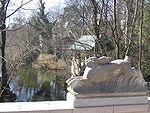
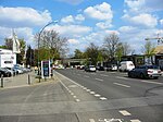
Hasensprungbrücke | Grunewald | The Hasensprungbrücke is a pedestrian bridge over the connecting ditch between Dianasee and Koenigssee . | cards |
|
Main road bridge | Friedrichshain | The main road bridge leads the Berlin Ringbahn over the main street, which begins at the northern end of Markgrafendamm and will be expanded to four lanes in 2015-2018. | cards |

|
Havel bridge | Spandau | The railway bridge was built during the construction of the Berlin-Spandau train station and the expansion of the high-speed line from Hanover to Berlin in 1998 based on a design by Schlaich Bergermann und Partner and replaces the previous truss bridge of the Berlin-Hamburg railway . It runs a total of seven tracks (including two S-Bahn tracks) across the Havel over three fields. On the north side there is a footbridge that connects the stave wood garden with the Stresow . The pedestrian crossing was the cause of long disputes after 1998, as it could not be built until ten years later (2008) due to numerous bureaucratic and technical difficulties. At the end of the 1990s there were temporary plans to connect a crossing on the south side for the Berlin – Hamburg maglev train . | cards |

|
Midwifery bridge | French Buchholz | The Hebammensteigbrücke is a pedestrian and cyclist bridge that is more than 100 meters long and runs between Blankenburg and French Buchholz over the A 114 and the Panke . It creates an east-west connection between the housing estate in Karow and Ferdinand-Buisson-Straße and is two meters wide. At this point, as early as 1770, a bridge between the two communities crossed the then wider (because it was swampy) river valley of the Panke. The name came about because the local connection was used by the Buchholz midwives for obstetrics in Blankenburg. | cards |

|
Heerstrasse Bridge | West end | The Heerstraßenbrücke leads the Heerstraße over the Spandau suburban railway . The S-Bahn station Heerstraße is located directly at the Heerstraßenbrücke . | cards |
| Heesestrasse Bridge | Biesdorf | Brick-built lower arch bridge, built in 1953, which leads Heesestrasse on the Wuhleblase over the Wuhle river and connects it to Heerstrasse in Kaulsdorf. | cards | |
 
|
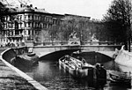
Hellersdorf Bridge | Hellersdorf | The bridge, which consists of two structures arranged one behind the other, leads Eisenacher Strasse over Neue Wuhle (top picture) and the bed of old Wuhle running parallel to the west (bottom picture). The eastern part of the bridge is 24 meters long and around 9.30 meters wide and contains footpaths on both sides. The western area is about 7.5 meters long and just as wide. | cards |
|
Hercules Bridge | Zoo | The Hercules Bridge is the third construction at this point. It spans the Landwehr Canal at the Bauhaus Archive . It connects the Lützowufer with the Corneliusstrasse / Von-der-Heydt-Strasse. In 1850 the first construction was built as the Moritzhof bridge , later called the Albrechtshof bridge. In 1891 a new massive vault bridge was built , which was named Hercules Bridge. The two decorative Hercules figures were designed by Johann Gottfried Schadow in 1787 and previously stood on the former Hercules Bridge on Hackescher Markt . Hercules fighting the Nemean lion (executed by Conrad Nicolas Boy (1753–1793)) is now in the Lapidarium Köllnischer Park , Hercules fighting the Centaur (executed by Schadow himself) has been lost since the bridge was destroyed in World War II . Two sandstone copies from 1792 are still standing at the entrance to Steinhöfel Castle Park . In 1950 the eastern part of today's bridge was built as unadorned reinforced concrete - arched , the western part in 1962/64 as a plate bridge made of prestressed concrete . | cards |

|
Hermann Bridge | Neukölln | The Hermannbrücke leads the Hermannstraße at the S-Bahn station Hermannstraße over the Berlin Ringbahn . | cards |

|
Hermann Ganswindt Bridge | Schöneberg | The Hermann Ganswindt Bridge leads the Vorarlberger Damm over the A 100 city motorway . The bridge is named after the inventor and rocket pioneer Hermann Ganswindt . | cards |
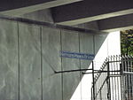
| Hermann Gladenbeck Bridge | Johannisthal | The Hermann-Gladenbeck-Brücke is a road bridge built in 2003 over the A113 directly on the Teltow Canal . It leads the Stubenrauchstrasse from the Massante bridge coming from Rudow over the new motorway to Johannisthal. It was named after the sculptor Hermann Gladenbeck . | cards | |
|
Hermann Maass Bridge | Moabit | The Hermann Maass Bridge is the middle of the three parallel bridges over the Westhafen connecting canal, which is only around 250 meters long, between the Berlin-Spandau shipping canal and the Westhafen . The bridge was named after Hermann Maaß , a German trade unionist, publicist, social democratic politician and resistance fighter of July 20, 1944.
The bridge was completely overhauled in 2011/2012 by the company Krebs und Kiefer on behalf of the Berlin Senate. |
cards |

|
Hertabrücke | Neukölln | The road bridge leads Ilsestrasse between the S-Bahn stations Neukölln and Hermannstrasse over the Ringbahn and connects Silbersteinstrasse with the residential areas at the Körnerpark . The steel element bridge was built in 1912. | cards |

|
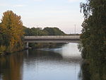
Heubuder Bridge | Healthy well | At the height of Heubuder Straße, this pedestrian bridge leads the Pankewanderweg over the Panke river . The structure, completed in 1995, is made up of external wooden trusses with a suspended continuous construction. The trusses carry support beams connected by hanging rods for the trough-shaped bridge structure. This consists of girders running across five fields with transversely screwed wooden planks as a walking area. Neoprene cushions form the bearings. The bridge is about 21 m long and 4.13 m wide. | cards |
|
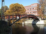
Hinckeldey Bridge | Charlottenburg-North | Construction from 1971–75, which replaced the previous bridge from 1952. The bridge leads the Kurt-Schumacher-Damm over the Berlin-Spandauer Schifffahrtskanal (Hohenzollern Canal ) and the Saatwinkler Damm. The total length of the bridge is 115 meters, with spans of 65 and 47 meters. The width is 35.5 meters. The opening took place on May 29, 1974, the final completion in September 1975. | cards |
|
Hiroshimasteg | Zoo | The pedestrian walkway, which was called Graf-Spee -brücke until October 1990 , leads over the Landwehr Canal and connects the Reichpietschufer with the Lützowufer east of the Bauhaus Archive . The steel two-hinged arch construction, designed by Klaus Theo Brenner and Benedict Tonon, dates from 1987 and is based on the design of the first wrought iron bridge from 1834, which was destroyed in World War II. | cards |

|
Hobrecht Bridge | Kreuzberg | The Hobrecht Bridge was built between 1899 and 1900 according to plans by Ludwig Hoffmann , initially under the name Grünauer Brücke , and connects the districts of Neukölln and Kreuzberg in the Friedelstrasse / Ohlauer Strasse over the Landwehr Canal . It also connects the two riverside streets Maybachufer and Paul-Lincke-Ufer . In 1954/55 this bridge was replaced by a new concrete building with a simple iron railing. The bridge bears the name of city planner James Hobrecht , who u. a. between 1891 and 1896 the Urbanhafen was built as the first larger urban port in the Landwehr Canal. | cards |
| Hobrechtsfeld Bridge | book | The Hobrechtsfelder Brücke leads the Hobrechtsfelder Chaussee over the Lietzengraben . | cards | |

|
(Elevated railway bridge U1) | Kreuzberg | The elevated railway bridge for the underground line 1 crosses the railway bridge of the former Anhalter Bahn , a riverside road and the Landwehr Canal. | cards |

|
(Elevated railway bridge U1 (street)) | Kreuzberg | The bridge of the U-Bahn at the corner of Oranienstrasse , Skalitzer Strasse and Wienerstrasse in 1900. | cards |
|
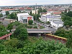
Elevated road bridge | Healthy well | It leads the Hochstraße diagonally over tracks in the Humboldthain area . Their length is approx. 62 m; the lanes are offset lengthways. | cards |
|
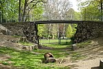
Hochwegbrücke | Pankow | The Hochwegbrücke is a pedestrian bridge in the Bürgerpark Pankow . | cards |

|
High bridge | Charlottenburg | The Hohe Brücke is a pedestrian bridge in the Charlottenburg Palace Park. | cards |
| High bridge | Rahnsdorf | The Hohe Brücke leads the Biberpelzstraße – Im Haselwinkel over the canal from the Müggelspree to the Hubertussee. | cards | |
| Hohenlohe Bridge | Friedrichshain | see Modersohn Bridge | ||

|
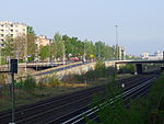
Hohenschönhausen Rhinstrasse Bridge | Old Hohenschönhausen | The bridge leads the Rhinstrasse north of Landsberger Allee over the route of the disused industrial railway Tegel – Friedrichsfelde . There is also a tram route over the approximately 21 meter long and 25 meter wide bridge. | cards |
|
Hohenzollerndamm Bridge | Schmargendorf / Wilmersdorf | The Hohenzollerndamm Bridge leads the Hohenzollerndamm over the Ringbahn and the A100 city motorway . There is direct access to the Hohenzollerndamm S-Bahn station from the bridge . | cards |
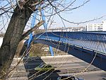
| Hoppendorfer Bridge | Koepenick | The structure is a brick arched bridge built in 1953, which leads Hoppendorfer Straße over the river Wuhle . It is 10 m long and about 9 m wide. | cards | |
|
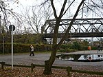
High arch | Wilmersdorf / Schmargendorf | The Hohe Bogen is a pedestrian bridge between Rudolstädter Straße and the green area at the Wilmersdorf stadium over the ring railway and the A100 city motorway . | cards |
|
(Hönower Weg / Zobtener Straße, railway bridge) | Rummelsburg | The nameless iron framework bridge leads railway systems over the S-Bahn station Rummelsburg and touches the fork Hönower Weg / Zobtener Straße. The bridge is 102 meters long and 7.50 meters wide. | cards |

|
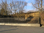
Hubertus Bridge | Wannsee | The Hubertusbrücke leads the Stölpchenweg over the Griebnitz Canal . | cards |
|
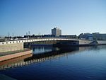
Hugo Heimann Bridge | Healthy well | The Hugo Heimann Bridge leads the Kühnemannstraße – Nordbahnstraße over the Panke . The bridge is named after the publisher and SPD politician Hugo Heimann . | cards |
|
Hugo Preuss Bridge | Moabit | In 1928 the name of the newly built Alsenbrücke was changed. Between 1933 and 1945 it was called the Admiral Speer Bridge . After being destroyed in the war, the structure had to be demolished. The bridge was officially run as the Humboldthafen Bridge (9123) and on August 23, 2004, the route was named the Hugo Preuss Bridge (9134). In 2005, the crossing of the shipping canal to the Humboldthafen was again navigable at the previous location. | cards |
 
|
Humboldthafen Bridge | Moabit | The Humboldthafen Bridge is a railway overpass structure that spans the Humboldthafen east of Berlin Central Station . The structure is the longest bridge construction on the Berlin light rail route. The Humboldthafen Bridge was awarded the German Bridge Construction Prize in 2008 . | cards |

|
Humboldtsteg | Healthy well | The footbridge is a pedestrian bridge over the tracks of the north-south S-Bahn, raised high. It extends from the Hochstraße directly into the Humboldthain . It is about 71 meters long and 3.90 meters wide. | cards |
Literature and web links
Individual evidence
- ↑ Halenseestrasse Bridge . In: District lexicon of the Luisenstädtischer Bildungsverein
- ↑ Press release of the Senate on the renovation of the Halenseestrasse Bridge , accessed on July 4, 2013
- ↑ Technical information on the Halenseestrasse Bridge on OSM
- ↑ One of the Halensee bridges on Structurae <s0008938>, accessed on July 4, 2013
- ^ Hannemann Bridge . In: Berliner Adreßbuch , 1915, part 5, Steglitz, p. 397.
- ^ District administrator Ernst von Stubenrauch . Waterways and Shipping Office Berlin
- ↑ Architectural monument Hansabrücke with staircases, jewelry and fountain
- ↑ Expansion of the main street from Markgrafendamm to Karlshorster Straße begins . Press release of the Senate Department for Urban Development and the Environment from September 18, 2015
- ↑ Bridge without access In: Der Tagesspiegel , September 26, 2006
- ^ Bridge construction after ten years of waiting In: Der Tagesspiegel , July 30, 2007
- ↑ Measurement table sheet # 1765. Volume VII Sheet 1 Schönerlinde. Recorded and drawn in 1839 by von Estorff Prem: Lieut: in the 13 th Inf: Regiment:
- ↑ Friedrich Wilhelm Karl von Schmettau: Maps of Prussia 1767–1787 . Reprint Potsdam 2006. Map 64 Sect. Bernau and Map 78 Sect. Berlin, also SBB under L 5421-64 and -78.
- ^ Former Hercules Bridge on Hackescher Markt, 1882
- ↑ Eckhard Thiemann: The Hercules bridges. A "fabulous" bridge name. (PDF; 2.2 MB) In: Journal of the German Museum of Technology Berlin Foundation and the Friends and Supporters of the DTMB e. V. , 22nd (46th) year, No. 4, Berlin 2006, p. 10f.
- ^ Roads and bridges for Berlin . stadtentwicklung.berlin.de; Retrieved July 16, 2014
- ↑ Overbridge . Senate Administration; Retrieved November 19, 2009
- ↑ Bridges to Tegel Airport . Leaflet, published by Senator for Building and Housing in October 1974.

