Urban port
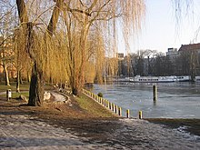
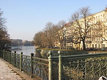
The Urbanhafen is an inland port of the Landwehr Canal in the Berlin district of Kreuzberg , which still bears the term port , but today no longer fulfills any port functions and has been reduced to a small, narrow basin. The construction was carried out in the 1890s opposite the confluence of the former Luisenstadt Canal , which connected the Landwehr Canal with the Spree in a short way to the north via the Wassertorplatz , Oranienplatz and the Engel basin .
Background: town planning and ports

Around 20 years after the Berlin customs wall (excise wall ) was torn down, the Landwehr Canal , which ran south of the city gates just below the wall, gradually moved into the “ interior ” of the city of Berlin. The as Hobrecht plan known development plan of the environments of Berlin of 1862 resulted in the southern areas of rapid development and construction, required the increasingly greater handling and storage areas for materials. While in 1872 20,600 barges passed the eastern entrance to the city on the Spree, the Oberbaum , only one year later there were already 30,000.
The small Schöneberger Hafen, built with the construction of the canal in 1852 on the site of today's Mendelssohn-Bartholdy Park, soon proved to be inadequate in terms of its size and equipment for the growing demands of cargo shipping and also belonged to the Prussian state . It was against this background that the Urbanhafen was laid out in the Landwehr Canal between 1891 and 1896.
The name "Urban" in its previous forms had been in use for centuries for the swampy terrain, which was known as "Urlake" or "Erlenlake". It has been drained by the Landwehrgraben since the 17th century, and later expanded into today's Landwehr Canal.
Even the Urbanhafen was no longer sufficient for its completion, so that in 1899, especially under pressure from Berlin merchants, plans were made to build two more large transshipment points with storage buildings, one in the west and one in the east. The realization of the East Harbor , which was built in the Spree opposite the mouth of the Landwehr Canal on Stralauer Allee , lasted until 1913. And until the completion of the first phase of the West Harbor at the (today's) confluence of the West Harbor Canal (1938) and Berlin -Spandauer Schifffahrtskanals (1859) in 1923 passed another ten years (the western section of the Berlin-Spandauer Schifffahrtskanals from the Plötzensee lock is also referred to as the Hohenzollern Canal on many Berlin maps after its historical name ).
The urban harbor
Equipment and technical data
For the basin of the Urbanhafen, the city planners extended the Landwehr Canal, which is around 20 meters wide on average, between the Baerwald and Admiral Bridge to around 145 meters. On the south side, a trapezoidal loading island, 293 meters long and 48 meters wide, protruded deep into the harbor basin . A 22-meter-wide side channel separated the island from the shore facilities, and it was navigable via a lift bridge .
Other technical data and restrictions
- Total area: 50,000 m², of which 19,000 m² is land
- Length 560 meters, width 140 meters
- Construction costs (at that time): 3.6 million marks
- Operator / owner: Berliner Magistrat ; from March 1, 1923 the recently founded state-owned Berliner Hafen- und Lagerhaus AG , BEHALA for short
- not suitable for larger ships (over Finow dimension )
- no siding
- Memory construction not possible due to the limited size
Loss of importance, deconstruction and today's situation
The listed restrictions soon led to the port's loss of importance. Maria Curter writes: “[It] was foreseeable that the only urban transshipment point, the Urbanhafen, would not be sufficient after the Lower Spree was canalized (1883-1894), the construction of the Mühlendammschleuse was nearing its end (1894) and with it large ships could pass through the city on the Spree. ”With the abandonment of the Luisenstadt Canal in 1926 and its transformation into a green corridor , the port continued to lose importance. In 1934, with the expansion of the charging island, there was a last small upswing, which however could not compensate for the shortcomings.
Since BEHALA also concentrated on transshipment in a few large ports, the port was finally obsolete in the 1950s. It was closed in 1963/1964, the harbor basin was filled, the side channel was filled in and the loading island was thus included in the southern bank area. A striking V-shaped extension of the Am Urban Hospital (now: Vivantes-Klinikum Am Urban) by Peter Poelzig , which originated between 1887 and 1890, stands on the site today . The loading zones gave way to a public promenade with a green area. The ships on the south bank are only "port staffage" and are used exclusively for catering .
Sports facility
After the decline in economic importance, the harbor was temporarily used as a route for motorboat races. "It is the first time that such a race is held, so to speak, in the middle of the sea of houses in the city," read the newspaper preview for the first race on June 21, 1936. There were other racing events after the war. "20,000 spectators at a motorboat regatta - the Urbanhafen was tightly lined ..." was the motto of the event on August 16, 1953. Because the course was too short and narrow for the ever faster racing boats, no more races were held in the harbor from 1956 onwards .
literature
- Hans Aschenbrenner: The opening of the west port . In: Berlin monthly magazine ( Luisenstädtischer Bildungsverein ) . Issue 9, 1998, ISSN 0944-5560 , p. 90-93 ( luise-berlin.de ).
- Maria Curter: For business to continue to flourish. The Osthafen through the ages . In: Berlin monthly magazine ( Luisenstädtischer Bildungsverein ) . Issue 9, 1997, ISSN 0944-5560 , p. 20-29 ( luise-berlin.de - quote p. 21).
- Michael Erbe: Berlin in the Empire (1871-1918) In: Wolfgang Ribbe (Hrsg.): Geschichte Berlins , second volume. CH Beck, Munich 1987, ISBN 3-406-31591-7 . See in particular the chapters Berlin as an industrial metropolis , p. 721 and Urban and Transport Planning , p. 732.
- Günter Richter: Between Revolution and Reich Government (1848–1870) . In: Wolfgang Ribbe (Ed.): History of Berlin , second volume. CH Beck, Munich 1987, ISBN 3-406-31591-7 . See in particular the chapter on urban expansion , p. 656.
- International motorboat regattas in June . In: Yacht , 1936, issue 18, p. 26.
- Race report. In: Illustrierter Motorsport , 1953, issue 16, p. 20.
Web links
- BEHALA
- Maps and pictures from pupils' hands - “My Kiez” from the Hunsrück primary school
Individual evidence
- ↑ Urbanstrasse. In: Street name lexicon of the Luisenstädtischer Bildungsverein (near Kaupert )
Coordinates: 52 ° 29 ′ 45 ″ N , 13 ° 24 ′ 32 ″ E


