
West Harbor Canal
| West Harbor Canal | |||||||||||||||||||||||||||||||||||||||||||||||||||||||||||||||||||||
|---|---|---|---|---|---|---|---|---|---|---|---|---|---|---|---|---|---|---|---|---|---|---|---|---|---|---|---|---|---|---|---|---|---|---|---|---|---|---|---|---|---|---|---|---|---|---|---|---|---|---|---|---|---|---|---|---|---|---|---|---|---|---|---|---|---|---|---|---|---|
 The Westhafenkanal in the area of the Westhafen, in the background the customs warehouse |
|||||||||||||||||||||||||||||||||||||||||||||||||||||||||||||||||||||
| abbreviation | WHK | ||||||||||||||||||||||||||||||||||||||||||||||||||||||||||||||||||||
| location | Berlin | ||||||||||||||||||||||||||||||||||||||||||||||||||||||||||||||||||||
| length | 3 km | ||||||||||||||||||||||||||||||||||||||||||||||||||||||||||||||||||||
| Built | 1938, 1954-1956 | ||||||||||||||||||||||||||||||||||||||||||||||||||||||||||||||||||||
| Expanded | until 2013 | ||||||||||||||||||||||||||||||||||||||||||||||||||||||||||||||||||||
| class | Vb | ||||||||||||||||||||||||||||||||||||||||||||||||||||||||||||||||||||
| Beginning | Spree km 6.48 above the Charlottenburg lock | ||||||||||||||||||||||||||||||||||||||||||||||||||||||||||||||||||||
| The End | Berlin-Spandau shipping canal km 8.32 | ||||||||||||||||||||||||||||||||||||||||||||||||||||||||||||||||||||
| Ports | West harbor | ||||||||||||||||||||||||||||||||||||||||||||||||||||||||||||||||||||
|
course
|
|||||||||||||||||||||||||||||||||||||||||||||||||||||||||||||||||||||
The Westhafenkanal (WHK) in Berlin is a federal waterway of waterway class Vb and is administered by the Berlin Waterways and Shipping Office.
Location and history
The Westhafenkanal is 2.9 kilometers long and has a water depth of 3.75 meters. It leads from the upper Schleusenvorhafen east of the Charlottenburg lock to Berlin's Westhafen and joins the Spree section of the Berlin-Spandau shipping canal east of the northern Seestrasse bridge . A few hundred meters in front of it, the direct journey from the Berlin-Spandau shipping canal to the Westhafen, the 240-meter-long Westhafen-connecting canal (WVK) of class IV, flows under the southern Seestrasse bridge. Construction began in 1938, was interrupted in the following years due to the Second World War and was only completed between 1954 and 1956. After passing the Charlottenburg lock on the way to the Westhafen, shipping from the lower Spree had to take the three-kilometer detour via the Spree and the Charlottenburg connecting canal , which is unsuitable for larger ships .
The initial state before the construction of the canal can be found on the maps from 1932 and 1946. For 1954, a canal route up to the Alte Tegeler Weg is already drawn and finally the canal route to the lock is completed on the 1955 city map, also on the map of 1961, but still to the old lock.
The Mörschbrücke , Goerdelersteg and Ludwig-Hoffmann-Brücke cross the canal . A subway line runs under the canal . This section of the tunnel for the planned U5 line currently ends at the unused platform in Jungfernheide station .
As part of the German Unity Transport Project No. 17 , the Westhafen Canal was widened on its northern bank by 2013.
Maps and pictures

Waterways in the Berlin region

Westhafenkanal at the lock Charlottenburg
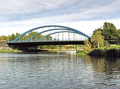
The Mörsch Bridge at the beginning of the Westhafen Canal

The Ludwig Hoffmann Bridge at the Westhafen


Web links
- Information about the Westhafenkanal. Waterways and Shipping Office Berlin, accessed on September 25, 2014 .
Individual evidence
- ↑ Directory E, Ser. No. 3 of the Chronicle ( Memento of the original of July 22, 2016 in the Internet Archive ) Info: The archive link was inserted automatically and has not yet been checked. Please check the original and archive link according to the instructions and then remove this notice. , Federal Waterways and Shipping Administration
- ↑ Lengths (in kilometers) of the main shipping lanes (main routes and certain secondary routes) of the federal inland waterways ( memento of the original from January 21, 2016 in the Internet Archive ) Info: The archive link was automatically inserted and not yet checked. Please check the original and archive link according to the instructions and then remove this notice. , Federal Waterways and Shipping Administration (Serial No. Annex 1 WaStrG BWa Str. Id No. 5403)
- ↑ H.-J. Uhlemann: Berlin and the Märkische waterways . DSV-Verlag Hamburg 1994
- ^ Charlottenburg around 1932: Westermann's plan of Berlin. Verlag Georg Westermann / Berlin W 40 / Braunschweig ( page no longer available , search in web archives ) Info: The link was automatically marked as defective. Please check the link according to the instructions and then remove this notice.
- ^ Charlottenburg around 1946: City map of Berlin. Verlag Richard Schwarz, Landkartenhandlung u. Geogr. Verlag, Berlin W.35 ( page no longer available , search in web archives ) Info: The link was automatically marked as defective. Please check the link according to the instructions and then remove this notice.
- ^ Charlottenburg around 1954: Pharus city map Berlin large edition. Pharus-Plan-Verlag in Treuhand / Berlin N54 / Schwedter Strasse 263 ( page no longer available , search in web archives ) Info: The link was automatically marked as defective. Please check the link according to the instructions and then remove this notice.
- ↑ City map Berlin 1955
- ^ Charlottenburg around 1961: Large Berlin city map. Verlag Richard Schwarz Nachf. / Berlin W 30 / Lützowstraße 32 ( page no longer available , search in web archives ) Info: The link was automatically marked as defective. Please check the link according to the instructions and then remove this notice.
- ↑ Berlin city map 1961
Coordinates: 52 ° 32 ′ 5 ″ N , 13 ° 18 ′ 24 ″ E