
Charlottenburg lock
| Charlottenburg lock | ||
|---|---|---|
.JPG) View into the lock area in the direction of the Westhafenkanal |
||
| location | ||
|
||
| Coordinates | 52 ° 31 '52 " N , 13 ° 17' 10" E | |
| Country: |
|
|
| Place: | Berlin | |
| Waters: |
Spree-Oder-Wasserstraße ( Spree / Westhafenkanal ) |
|
| Water kilometers : | km 6.10 | |
| Data | ||
| Owner: | State of Berlin | |
| Responsible WSA : | Berlin , outskirts of Spandau | |
| Start of planning: | 1997 | |
| Construction time: | 1998-2003 | |
| Start of operation: | December 2003 | |
| Renovation: | Replacement for "Old Lock" from 1885 | |
| Shutdown: | The neighboring old lock can be used if necessary. | |
| lock | ||
| Type: | Inland lock | |
| Category: | Large motor cargo ships | |
| Usable length: | 115.00 m | |
| Usable width: | 12.50 m | |
| Height upstream : | 33.1 m above sea level NN | |
| Average height of fall : |
1.23 m | |
| Upper gate: | Rotating segment gate with filling shell | |
| Lower gate: | Stemmtor with shooters | |
| Fill chamber; to empty: | 15 minutes | |
| Others | ||
| Was standing: | July 2008 | |

The Charlottenburg lock is a lock on the Spree in the Berlin district of Charlottenburg-Wilmersdorf . It connects the higher water level between the Mühlendamm barrage and the Charlottenburg barrage (with the weir in the Jungfernheide ), the Berlin-Spandauer Schifffahrtskanal , the Westhafen and the Westhafenkanal on the one hand with the lower water level of the lower reaches of the Spree to the confluence with the Havel and the Havel Havel lake area to the suburban lock Brandenburg an der Havel on the other hand. The Charlottenburg lock is located at kilometer 6.10 of the Spree-Oder-Wasserstraße federal waterway . The Berlin Waterways and Shipping Office is responsible for operation and maintenance . The total length of the facility including the outer harbors is 1585 meters, of which the total length of the lock is 152.5 meters. The water depth at underwater is 4.00 meters and is influenced by the neighboring Spree weir. A lock takes 15 minutes. The call channel is on VHF channel 82.
history
The first barrage of the Spree in what was then the city of Charlottenburg was built between 1883 and 1885. 1959–1961 the double lock was repaired and brought up to the state of the art at the time. Its two lock chambers are each ten meters wide and have a usable length of 65 and 82 meters, respectively. The old lock system is no longer used. In the mid-1950s, the lower reaches of the Spree were straightened up to the confluence with the Havel for technical reasons relating to shipping. In 1956, with the completion of the Westhafen Canal, inland vessels with a load capacity of up to 1000 tons could reach the Westhafen in Berlin. Already in the 1930s there were considerations for the construction of a new twin lock in Berlin-Charlottenburg . At that time, a plot of land was contractually reserved for this purpose.
The new Building
The new lock at Charlottenburg is part of the German Unity Transport Project No. 17 . This project includes the expansion of the waterway between Hanover via Magdeburg to Berlin. This waterway will be made economically navigable for large motor goods ships with a length of 110 meters and a width of up to 11.40 meters and push convoys with a length of up to 185 meters and the width mentioned. With the completion of the Magdeburg waterway junction in October 2003 and the commissioning of the new Charlottenburg lock in December 2003, it is now possible for these ships to reach Berlin's Westhafen from the Western European waterway network. The lock area includes coupling and waiting areas for commercial shipping as well as sports boat waiting areas in the outer harbors.
technology
The lock chamber was built using a steel sheet pile construction . It is closed at the top by a rotating segment gate with a filling valve. The lower head is closed by a stem gate with riflemen. In front of the gates in the interior of the lock chamber, there are shock protection devices in the form of removable steel cables to protect the gate against ship impact.
Accompanying measures
The accompanying measures for the construction of the new lock included the creation and expansion of continuous footpaths and cycle paths on the north side of the lock from Nonnendamm to Mörschbrücke . On the south bank of the Spree from the Charlottenburg Palace Park to the Rohrdammbrücke , the riverside path was renovated as a compensatory measure. With the construction of the new lock, an island was created between the old and the new lock. This is not identical to the location known as the “lock island” between the Spree with the Spreewehr and the old lock. With the construction of the direct connection, the eastern part of the Nonnendamm sank. In order to reach this island location, a high bridge in the south arch with steep ramps was built at the Westvorhafen. New green areas were created and trees were set in the entire lock area. The inclined banks that were created were greened and reed planted in some areas . Old structures were removed and the floor unsealed. Amphibian exits were built.
- Lock and lock land

Lock area
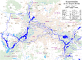
The waterways in and around Berlin

Stemmtor in the lower head with shock protection rope

Information board with information on the state and history

Spreewehr from the Spreeweg


_Schleuse_Charlottenburg.jpg)
.jpg)
literature
- H.-J. Uhlemann: Berlin and the Märkische waterways . DSV-Verlag, Hamburg 1994, pp. 115-118, 138 ISBN 3-344-00115-9 .
- Writings of the Association for European Inland Shipping and Waterways e. V. WESKA (Western European Shipping and Harbor Calendar), Binnenschifffahrts-Verlag, Duisburg-Ruhrort. OCLC 48960431
cards
- Folke Stender: Editing of Sportschifffahrtskarten inland 1. Nautical publication Verlagsgesellschaft, ISBN 3-926376-10-4 .
- W. Ciesla, H. Czesienski, W. Schlomm, K. Senzel, D. Weidner: Shipping maps of the inland waterways of the German Democratic Republic 1: 10,000. Volume 4. Editor: Waterways Authority of the GDR, Berlin 1988, OCLC 830889996 .
Web links
- Official website of the waterway construction authority
- Lock Charlottenburg on the side of the district office
- Berliner Zeitung : Without the weir, Berlin's parks would wither . July 26, 2001.
- Press release No. 09/2003 of WSD Ost - New lock Charlottenburg completed
- Safety measures on bridge piers susceptible to settlement when building the new lock in Charlottenburg
- New ship lock Berlin-Charlottenburg (pictures of the construction)
- New lock construction and weir renovation
- google-books - Schwab Becker: Yearbook of the Port Technical Society