
Nonnendamm
| Nonnendamm | |
|---|---|
|
|
|
.jpg) |
|
| Nun's dam on the island between the locks | |
| Basic data | |
| place | Berlin |
| District | Siemensstadt , Charlottenburg-Nord , Charlottenburg |
| Created | as a stick dam in the 14th century |
| Newly designed | 2003 |
| Connecting roads | Siemens factory premises (west) |
| Cross streets | Nikolaus-Groß-Weg (north) |
| Numbering system | Horseshoe numbering |
| Buildings | Bypass bridge during the construction of the (new) lock Charlottenburg |
| use | |
| User groups | Pedestrian traffic , bicycle traffic , local traffic |
| Technical specifications | |
| Street length | 800 meters |
The Nonnendamm is part of one of the oldest streets in the Berlin urban area. It formed the historical connection between Spandau and Berlin, which led through Moabit . The route of the road was subsequently changed several times, including by converting parts of the road. The importance of the Nonnendamm has decreased significantly due to changes in traffic management. A residential street has remained since the 2000s . To the west it was built over by Siemens premises, the eastern area was interrupted by the outer harbor of the new lock.
location
At the time when Greater Berlin was formed, Nonnendamm was located both in the urban district of Spandau (Spandau had been a town since 1232) and in the Siemensstadt area of the city of Charlottenburg . In 1920, the Berlin administrative districts Spandau and Charlottenburg were formed. This district division remained since then except for slight shifts of the district boundary condition, while the dam was temporarily in border location of the districts. During the district reform in 2001, the districts were reorganized below the district level. The short section in Spandau has since continued to be in Siemensstadt , the larger eastern section, along with the roads and the northern properties, is in Charlottenburg-Nord . Part of the southern roadside is located in the Charlottenburg-Wilmersdorf district , which forms the border between its districts Charlottenburg and Charlottenburg-Nord .
The name "Nonnendamm" as a route designation is causally related to the southern edge of the Nonnenwiesen , but it was used on Spandauer Terrain as an alternative to the designation of the continuation and for the entire surrounding area. When Siemens settled in the factory , the place name "Colony Nonnendamm near Berlin" (from 1914 named in "Siemensstadt") was created. In the Spandau area, the widened and expanded section of Nonnendamm was named Nonnendammallee in 1914 .
Origin of name
The name of the street goes back to the Benedictine monastery of St. Marien in Spandau, founded in 1239 and closed in the 16th century . It stood south of the former city fortifications not far from the Havel . The monastery owned areas to the west in what is now Spandau's location in Klosterfelde , and other monastery properties were located in the east to Moabit and Wedding . Jungfernheide and the Nonnenwiesen were named after these former owners of the area - the "virgin" Benedictine nuns. This is how the Jungfernheideweg, the Jungfernsteig, the Nonnendamm, the Nonnendammallee and other Siemensstadt street names with the endings … damm,… weg and … climb .
history
The oldest road between Spandau and Berlin led from the Berliner Thor south of the citadel in Spandau along the north bank of the Spree towards Jungfernheide and further south around the Nonnenwiesen through Moabit to the Spandauer Tor in Berlin. In 1569 the Berlin Gate in Spandau replaced the mill gate that had been demolished for the construction of the fortress. The long-distance and trade route from Magdeburg to the pilgrimage site Gnesen in Poland ran through the lowlands on the north bank of the Spree as Nonnendamm. A route between Berlin and Spandau on the slope of the Teltowplatte and thus south of the Spree was only created with the development of Charlottenburg.

The Spandau nunnery had a stick dam built through the wetlands, which is documented by the name Nonnen "damm" between the Spree and Nonnenwiesen. “Within these [Spandau] borders, however, were areas that did not initially belong to the urban soft image; These are the Behnitz, the margravial cutting mill located on the same, the monastery mill, the Marienkloster and its possessions, the Götelwiesen and the terrain which the dam and the Körnersche cutting mill now occupy. [...] the Klostermühle, the former properties of the Marienkloster, Klosterhof and Klosterfelde and the Götelwiesen [were] incorporated into the city on October 1st, 1872. “Sometimes only the area of the Knüppeldamm is referred to as“ Nonnendamm ”, depending on the source but also the continuation to Spandau.
Spandau
The trunk road between Magdeburg via Berlin to Poland led through Spandau. In the Berlin urban area, this route was changed in the 19th century to the course of the federal highways B 1 via Küstrin and B 5 to Frankfurt .
Until 1878 Spandau could be reached through the southern Klosterviertel and the Kloster-Thor (since 1747: Potsdamer Thor ) on the Potsdamer Provinzialchaussee (since 1878: Klosterstraße ), after which the Havel crossing was used. In 1626, Elector Georg Wilhelm ordered the building of the monastery to be demolished in order to expand the city fortifications. The area to the east of Spandau in the north of the Spree (up to Tegeler Weg ) consisted of a 500 to 1000 meter wide, damp and swampy terrain with numerous arms of the Spree. The dam on the Nonnenwiesen was part of the old trade route . The Hühnerwerder was originally a wetland south of an arm of the Spree. Depending on the viewer, it was referred to as the way to Spandau or the way from Spandau , but continued as the Spandauer Heerweg to Berlin. The Königsdamm over the northern and higher areas later supplemented the Nonnendamm, which unfavorably led through damp terrain near the Spree.

Until the beginning of the 20th century, the Nonnendamm was an unpaved road. In the 18th and 19th centuries , the Berliner Chaussee was paved from the Berliner Thor in Spandau in the course between Rohrbruch and the Citadel . The traffic train from Paulstern ran as a solid road on the one hand to Sternfeld and on the other northwards through Haselhorst to Tegel . From Paulstern to the east, the path from / to Spandau or the path from / to Charlottenburg follows and is sometimes referred to as Nonnendamm along its entire length. The route ran from west to east over the elevated terrain on the Sternberg ( 42 m above sea level ), past the Weißen Sandberg and along the southern edge of the Jungfernheide. The Nonnendamm led through the wetland, which extended to the Nonnenwiesen in the north and the unregulated Spree in the south. The path led to the bank of the Spree with a south arch. At this point on the Spree, the old lock Charlottenburg , the lock Nonnendamm, was built in the mid-1880s . The course of the trunk road to the east as Spandauer Heerstrasse from the intersecting Chaussee Charlottenburg – Tegel led spreenah to Moabit, Wedding and Berlin. "The Spreewiesen in the east of the manor district on Nonnendamm are actually considered to be part of the municipal district, but have not yet been officially incorporated." and the Spreebogen opposite the castle is noted as Nonnendamm . The western connection is called Alte Straße von Charlottenburg , the eastern course to Eisenham̄er Martinicke on the Spreenordbogen in front of the Judenwiese is not named on the map.
Charlottenburg

From 1700 Charlottenburg Palace was built in the village of Lietzow and with the development of the city , the Nonnendamm gained importance for the route from Charlottenburg to Spandau. The connection from Charlottenburg to Spandau initially reached north over the Schlossbrücke on the Spree ( Tegeler Weg ) and continued on the Nonnendamm over the path to Spandau . In the 18th century, Charlottenburg was predominantly populated by arable citizens. The city tried with the king to preserve the meadows and field marrow north of Nonnendamm.
In the 1880s the Spree was regulated, the Spree weir and the Charlottenburg lock were built. The Hühnerwerder was now north of the Spree and the Nonnendamm since then on its north side. In addition, the Königsdamm located to the north between Haselhorst and Plötzensee became more important as it led over the higher terrain of the Jungfernheide.
The importance of the Nonnendamm declined when the Spandauer Damm traffic train was built in the 1820s to complement the Kunststraße Berlin / Spandau to Hamburg . This newly created road south of the Spree via Charlottenburger and Spandauer Chaussee ( Spandauer Berg ) ran above the break of the Teltowplatte and was free from Spree floods. The Lehrter and Hamburger Bahn were also laid out on the southern bank of the Spree . Charlottenburg was also favored for the traffic between the two cities of Berlin and Spandau, because from "April 1718 no more passage over the Jungfernheide to Spandow suffered, but it should be laid over Charlottenburg according to regulations." In order to improve the importance of Charlottenburg it was the intention of the royal administration to strengthen the southern connection between Spandau and Berlin. This location over the Stresow had initially lost its historical importance.
The border of the areas belonging to the city of Charlottenburg and the urban district of Spandau lay on and around the Nonnendamm. The Charlottenburg terrain in the east was used as meadows, forest and arable land. The Spandau site on the other side of the Havel was largely impassable, unused wasteland . When the Spandau armaments industry was expanded to Haselhorst, the infrastructure remained north of the Nonnendamm.
Nonnendamm Colony

At the end of the 19th century, Siemens' production facilities were scattered across the Berlin area. The fallow area north of the Spree around Nonnendamm belonging to the city of Spandau was selected for a new location . This was an almost uninhabited, traffic-wise scarcely developed natural landscape consisting of forest, meadows, heathland and wetlands between the Nonnenwiesen, Hühnerwerder, Rohrbruch and Jungfernheide. This area joined the Spandau industrial areas on the terrain of the Haselhorst estate district. In 1897 Siemens & Halske AG acquired an area of 209,560 m² on the Hühnerwerder. The only transport links to Spandau, Charlottenburg and Berlin were the Spree and the unpaved Nonnendamm.
On Kissling's large special map of the Berlin area from 1905, the Nonnendamm is shown as a “better way” on the southern edge of the Nonnenwiesen (dry meadow). To the north along the city and district limits of Charlottenburg, it has a connection to Königsdamm after 500 meters, which is an “easy way”. From the Chaussee coming from Spandau from Paulstern, where the road turns to Tegel, a route of the Nonnendamm is entered as an “improved route”. It leads north of the wet meadows past the Sternfeld and turns as a marked road around the waterworks to the south into the course of the Rohrdamm. Across the Spree was the Fürstenbrunn (HP) stop , where workers from Berlin and Charlottenburg arrived. The Rohrdammsteg (Märkischer Steg) was built at the expense of Siemens.
Initially, the (expanded) Nonnendamm was the only supraregional road connection with neighboring towns for the Siemens locations. From 1905 Siemens fortified the Nonnendamm in the Spandau area as Chausseestrasse. With the construction of the large works in Siemensstadt from 1906, the "Nonnendamm" was expanded to a width of 49 meters with the company contributing to the costs. Since 1913, as a supplement to the east through the Charlottenburger Terrain in the direction of Moabit, the building as Siemensdamm followed . According to a letter from the Spandau police administration to the magistrate on April 2, 1914, this new course was named Nonnendammallee . A section of Nonnendamm was included in Siemensdamm in 1914. Nonnendammallee is included in the address book in 1915. The residential suburb of Kolonie Nonnendamm was first mentioned in the address book in 1910. The Nonnendamm and the cross streets between Rohrdamm and the Charlottenburg district are marked with construction sites. For the city of Charlottenburg, the organizational assignment as a separate city district Nonnendamm is included in the address book 1910 . During this time, the Nonnendamm ran between Tegeler Weg and the Nonnendamm colony and contained some residential buildings, factory properties and the office of the lock administration. There is also the postal address Nonnenwiese as going from Nonnendamm. The map in the 1910 address book also shows no parcels on and around Nonnendamm in the Spandau area between Sternfeld and Siemens & Halske-Kabelwerk, which is south of the Alte Spree in the bend of the Hühnerwerders. To the east of the Charlottenburg terrain, the area (the Nonnenwiesen) from Nonnendamm to Königsdamm (which is the city limit along the Jungfernheide) to Tegeler Weg is parceled out and traversed by planned, as yet unnamed streets. This speaks for the intention to build a city quarter for Siemens workers east of the Siemens works and the colony in Spandau.
In 1911, numerous houses and factories were entered in the address book for the Spandau territory. is (still) Nonnendamm in the "Kolonie Nonnendamm" from the district Sternfeld (Siemens = Schuckert = works) via Rohrdamm, Straße 1 , Straße 1a , Brunnenstraße , Straße 2a , Voltastraße, Märkischer Steig , Reisstraße, Hefnersteig, Ohmstraße, Siemensstraße to the local area Charlottenburg and back Brunnenstraße , projected street , Rohrdamm to the Haselhorst district. For the municipality of Charlottenburg On the north side, the property of the Jungfernheide Boden AG station was at the eastern end, to the west the lock administration and several inns' houses followed. On the south side of the west in the direction of Tegeler Weg were the Siemens-Schuckertwerk, a hard stone factory, a mortar factory, a branch of the Wernerwerk, the pumping station north of the Spree and the Urban and Lemm chemical factory.
Siemensstadt
The Nonnendamm colony was connected to local public transport from 1905 to the Fürstenbrunn stop on the Hamburg Railway. Siemens built the Märkischer Steg over the Spree at its own expense for a better connection from the Fürstenbrunn train station to the factory buildings. In later years, a railway bridge financed by Siemens over the Spree was added to the direct connection of the area north of the Spree; The S-Bahn was then led from Jungfernheide to Gartenfeld . The Haselhorst military railway was used for freight traffic and expanded as a Siemens freight railway with partial guidance on the median of Nonnendamm (from 1914: Nonnendammallee).
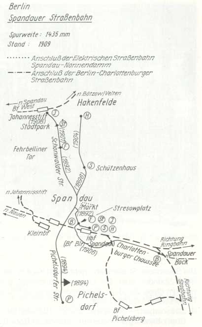
In 1914, the Spandau city administration changed Nonnendamm b. Berlin in the district Siemensstadt . At that time it had 7,000 inhabitants and housed a further 23,000 employees. In nearby Haselhorst , at the same time as the Siemens settlement, a residential colony for the Prussian military treasury was established to accommodate the workers of the army canning factory. In 1908, the Spandau – Nonnendamm electric tram was set up on the new Nonnendamm to connect businesses and residential buildings .
Development of the Nonnendamm between 1920 and 1960

With the Greater Berlin Act of April 1920, the cities of Spandau and Charlottenburg became part of Greater Berlin and their city limits on Nonnendamm became district boundaries.
Planning and implementation
The route of the historical route of the Nonnendamm with the curve to the south to the Spree will be replaced by the expansion of a heavier traffic road connection Nonnendammallee / Siemensdamm, which was planned since the 1910s and was interrupted during the First World War.
The formation of Greater Berlin in 1920 supported the continuous planning of the Berliner Chaussee traffic train past the citadel over Nonnendammallee to the east into Siemensdamm . This is configured and created. Siemensdamm continues the width of Nonnendammallee for the traffic from Siemensstadt to Charlottenburg and Berlin expected at the time. From the beginning it was designed to relieve the ("old") Nonnendamm and lead via Siemensplatz to the east connection at Nonnendamm on the Spree, where it connects to the north and south of the Tegeler Weg. Siemensdamm was the southern main street for the planning of a “ Charlottenburg-Nord settlement ” on the Nonnenwiesen site, with Holtzdamm and Königsdamm following parallel to the north . However, residential construction didn't begin until after World War II in the 1950s and 1960s. During this time, the traffic situation and road connections were further changed through the planning and construction of the city motorway and the northern motorway . The “New Connection Canal”, which began before the war years, was completed, and for the Tegeler Weg this resulted in a guided tour over the Mörsch Bridge . The road construction changed the location from Siemensdamm to Nonnendamm.
In 1925, the Siemens freight railway was in existence along the length of Nonnendammallee as far as Rohrdamm on the district border of Charlottenburg and supplied Siemens & Halske and Schuckertwerke. It evades the housing estate to the east to the south. The Spandau – Nonnendamm (-Charlottenburg) tram ran on the Berliner Brücke ( Juliusturmbrücke ) over the Havel and after the Berliner Chaussee (Am Juliusturm) through Haselhorst in the northern arch on Gartenfelder Strasse (with a connection to the cable works) and on over the Schwarzen Weg (Paulsternstraße) to Nonnendammallee. The route to Charlottenburg was on Nonnendamm along the lock canal to Tegeler Weg and Jungfernheide train station, from there to Moabit.
Representation based on Berlin city maps
On the map from 1921, Nonnendamm leads east along the border between the Spandau and Charlottenburg districts and in Charlottenburg on the lock canal to the Tegeler Weg north of the railway line. Nonnendammallee is located exclusively in the Spandau district. Then the (projected) Siemensdamm is drawn across Siemensplatz to Tegeler Weg, which leads through the residential district of Charlottenburg-Nord, which was already subdivided before the First World War .
The map from 1926 shows a similar distribution with the expanded Siemens factories on Nonnendamm. Siemensstrasse forms the connection from Rohrdamm via Brunnenstrasse and Reisstrasse to Nonnendamm.
In 1932, part of the Wernerwerk was located south of the newly created Wernerwerk S-Bahn station, east of Nonnendamm in the Charlottenburg area. According to the map, Nonnendamm no longer had a direct connection to Nonnendammallee. The (remaining) Nonnendamm was connected at the southern end of the residential area streets by Siemensstraße with Nonnendammallee / corner of Rohrdamm. The Nonnendammallee itself was shortened in favor of the Siemensdamm, which leads into Siemensstadt.
The district boundary at Nonnendamm, which was changed in 1938, is entered on the map from 1943, so that a western part of Nonnendamm with the Wernerwerk site belongs to Siemensstadt. On the maps from 1943 and 1946, Siemensstrasse is renamed Schwiebertweg in the same course (up to Nonnendamm) .
In 1954, the end of the Nonnendamm in the east on Tegeler Weg was changed and it ends at the (still) planned junction and the (newly named) Alte Tegeler Weg. This route change was made because the Westhafen Canal is being extended directly to the Spree via the Charlottenburg connecting canal. In the west, the Nonnendamm joins the route of the Wernerwerksdamm. Its names were Siemensstrasse until 1939 and Schwiebertweg until 1947. With the completion of the new connecting canal , which was already in front of the Teltower Weg in 1943, the Nonnendamm is now in a historical location in the east under the Mörschbrücke and through to the Tegeler Weg.
.JPG)
In the mid-1950s, the new course of the Tegeler Weg from Siemensplatz to the new bridge structure and the connecting canal was under construction. A 15-meter-wide side section of Siemensdamm as a bypass meets Nonnendamm, 130 meters east of the lock, which leads to the “Alten Tegeler Weg”. This bypass complements the previously existing connection between Nonnendammallee and Tegeler Weg. The Nonnendamm located directly on the Spree and its importance as a street decreased, because the old street course was no longer renewed.
The connecting canal was completed in 1960 and the planned route for the city motorway in Goerdelerdamm was entered on the map. The motorway was run with the north-west arch bridge as an elevated road without affecting the Nonnendamm over it. The Nonnendamm is almost undeveloped in 1960. In 1961 the section between the mentioned bridge to Goerdelerdamm has not yet been completed.
Situation since the 1960s

The section of Nonnendamm, which initially ran through the Siemens factory premises in Siemensstadt, was redeveloped on November 1, 1960 . Since then, the Nonnendamm has had no traffic significance due to the expansion of Siemensdamm and the city motorway. Since the section west of the Siemens factory gate was deedicated, access to commercial buildings, the allotment gardens and the lock administration has been restricted to Nikolaus-Groß-Weg . The section between Nikolaus-Groß-Weg and Tegeler Weg had belonged to Charlottenburg since 1960. In 2004, the "residential area Charlottenburg-Nord" with the surrounding northern part of Charlottenburg was created as an independent district by resolution of the district council meeting of the district of Charlottenburg-Wilmersdorf on September 30, 2004. The Nonnendamm on the Schleuseninsel became the border between the two districts that had been created, with the street area belonging to Charlottenburg-Nord.
.JPG)
Since the 1930s there have been considerations to build a new lock on Nonnendamm, the lock area has meanwhile been leased to the KGA. The construction of the new lock Charlottenburg , which began in 1999 and was completed in 2003, interrupted the Nonnendamm east and west of this lock. The outer harbors on both sides of the lock are in a straight line as an extension of the Westhafen Canal to the lower Spree, the connection of which was straightened so that an island was created between the old and new lock.
The Charlottenburg section of Nonnendamm to Tegeler Weg (Mörschbrücke) was canceled by the eastern outer port of the new lock. It was interrupted between property 27 and 29 by the western lock outer harbor. A high bridge with long ramps was built between lots 25/27 and 29/31 for access to the island .
Information in the Berlin street directory
The Nonnendamm ( Spandauer Westende , Nonnendamm / corner Nikolaus-Groß-Weg , Ostend Nonnendamm am Kanal ) has consisted of 670 meters of residential street since the 1990s, of which 100 meters are in Siemensstadt. The street list of Charlottenburg shows 700 meters for street number 3259 and 100 meters for Siemensstadt. This street is classified in the RBS class "VWEG" (connecting route) and is not categorized in the street development plan (StEP) (class V), as it is of no importance for urban planning. However, according to the OKSTRA class "G", the state of development is subject to the conditions of a municipal road, which is why the canal bridge (western exit of the new Charlottenburg lock) is newly built and expanded accordingly. The official information on the national map series in the Berlin street list is the same for the districts of Spandau (Siemensstadt) and Charlottenburg-Wilmersdorf (Charlottenburg-Nord). The postcode is 13627. It can be accessed indirectly in local public transport in zone B by bus 123 and via Nikolaus-Groß-Weg by the U7 underground line (Halemweg).
The plots 1–57 (even) and north 2–40 (odd) are located south of Nonnendamm in orientation numbering. The district border crosses between the state fire department (belongs to Nikolaus-Groß-Weg) and property 40 as well as 35 and 37 over Nonnendamm.
Location of the plots in Charlottenburg

The Nonnendamm from plot 35 in Charlottenburg-Nord (on the southern edge for 160 m before the canal bank the border with the district of Charlottenburg) ends as a passable road east of the (old) lock administration on Nonnendamm 11. The plot Nonnendamm 1, which is still included in the detailed network map, is located on the Tip of the island (as a street) into the channel. Plots 2 and 4 of Nonnendamm are also located on its north side due to the canal construction.
On the island on the south side of Nonnendamm, to the east of the motorway bridge, there are lots 27–13 (odd). The building of the Künstlerhaus Berlin on Nonnendamm (formerly Urban-Lemmsche Chemiefabrik) stands on the built-up plot of land at Nonnendamm 17/19 (which can be seen clearly from the city motorway ). The other properties are unused green spaces between the new canal and the Spree. The “Bleibtreu II allotment garden complex” (parcels 22–43, property Nonnendamm 6/10) and the waterways office building in the administration of the old Charlottenburg lock and the new lock are located on Nonnendamm on the island part .
On the mainland side , the two commercial buildings are on the Spandau district border (Siemensstadt district) / corner of Nikolaus-Groß-Weg on plots 33 and 35.
On the north side of the canal, the new lock building rises on the Nonnendamm 24 property. West of the motorway bridge is a green area called Nonnendamm 26–30. This is a former part of the allotment garden, which was dedicated to the east of the fire brigade headquarters for the removal of material from the fire brigade. This area is reserved as a warehouse for fire extinguishing equipment, which is to be accommodated when Tegel Airport is closed.
To the north of the (new) canal, a road remained to the KGA 'Bleibtreu' and the (grassland) plots of Nonnendamm 2 and 4. This ultimately leads (in the course of the old route) under the Mörschbrücke and the motorway to the Alter Tegeler Weg and joins the Goerdeler / Reichweindamm. This remnant of the historic street is designed as a footpath / partly driveway, but no longer referred to with the name "Nonnendamm".
Location of the properties in Spandau / Siemensstadt
In Siemensstadt, a short section of Nonnendamm remained (after the deedication) west of Nikolaus-Groß-Weg with commercial buildings. On the north side there is a commercial area on parcel 40. The building in front of it is assigned to the Nikolaus-Groß-Weg property, the connecting bridge to the craftsmen's specialist market (Nonnendamm 35) crosses the district boundary. Plots 37–57 are on the south side. In front of the entrance of the Techno-Park to the disused Spreealtarm there are 37 and 39/41 with commercially used buildings and areas. The following properties on Nonnendamm are rooted in the history of Siemens and follow the new use in Technopark. No longer called a street are the commercial and commercial buildings 43-47 on the triangle (Ex-) Nonnendamm, the Spreealtarm (created with the lock) and the railway system of the disused “Siemens S-Bahn”. The workshops 51 and 53 as well as the farm building 49 are located with driveways to the west behind the railway embankment and to the west border the properties assigned to Wohlrabedamm. The land area of Nonnendamm also extends to the exposed northern arm of the Spree. This old arm has existed since 2003, when this arm was closed by the straight course of the waterway from the Westhafenkanal to the Spree through the western lock outer port of the new lock.
- The Nonnendamm in the middle of the 2010s

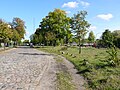
Nonnendamm to the Siemens gate in Siemensstadt

Nonnendamm from Nikolaus-Groß-Weg to the west
Nonnendamm to the east to property 11, on the right district Charlottenburg

Street and property location on Nonnendamm

Operation building of the "new" lock (Nonnendamm 24)
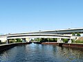
Nonnendamm bridge from the western Schleusenvorhafen, behind it the city ring bridge

Bridge approach to the island, behind it highway bridge

Bridge exit, view of the Künstlerhaus
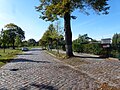
Nonnendamm at KGA 'Bleibtreu', on the left the district of Charlottenburg

repealed Nonnendamm on the north bank of the canal


.JPG)


See also
Web links
- Nonnendamm. In: Street name lexicon of the Luisenstädtischer Bildungsverein (near Kaupert )
- The industrial estate "Spandau-Nonnendamm" becomes "Siemensstadt" . Siemens.com; accessed on May 1, 2015
- Land on Nonnendamm. accessed on May 1, 2015, from FIS-broker
- About the location of the Nonnendamm and its surroundings. accessed on May 1, 2015, from google.de
- Address search Nonnendamm. Geoportal Berlin; Retrieved June 2, 2015
Individual evidence
- ↑ cf. in addition "Spandauer Viertel" in JGA Ludwig Helling (ed.): Historical-statistical-topographical pocket book of Berlin and its immediate surroundings . HAW Logier, Berlin 1830. Online at books.google, accessed on May 1, 2015.
- ↑ Street names around the Nonnendamm from detailed network illustration 2015, accessed on May 1, 2015.
- ↑ Felix Escher, Wolfgang Ribbe: Städtische Siedlungen im Mittelalter - “[…] more important, at least for the Central Mark region, were the west-east connections on land, for example the road from Magedeburg to Spandau, which crossed the Havel here and then along the Nonnendamm to Berlin, from where it continued to Küstrin and with a branch in Müncheberg to Frankfurt a. d. Or ran. ”(Google books), accessed on May 1, 2015.
- ↑ a b O. Kuntzemüller: Documented history of the city and fortress Spandau . P. 30, accessed on May 1, 2015.
- ^ Yearbook for Brandenburg State History, Volume 51, p. 66, Landesgeschichtl. Association, 2001 : “As these are obsolete and now unknown names; This is how the izo of the city of Gränen is called: Towards morning it borders in front of the Berlin Gate with the Royal Office behind the golden star as far as the Nonnendamm and goes around the border to the right through the aforementioned water, called the crowel or crewel (which is an arm is what the Havel does) […] ”, accessed on May 1, 2015.
- ↑ Timetable for the Diocese of Magdeburg , accessed on May 1, 2015.
- ↑ Joachim Pohl: The Benedictine nunnery St. Marien zu Spandau. P. 559 f.
- ^ Map of the country initially Berlin . Publishing house d. Royal Prussia. Land recording (1869 with corrections up to 1890), ( Memento of the original from April 13, 2016 in the Internet Archive ) Info: The archive link has been inserted automatically and has not yet been checked. Please check the original and archive link according to the instructions and then remove this notice. accessed on May 1, 2015
- ↑ Charlottenburg around 1894 on the area around Berlin , Bibliographisches Institut in Leipzig, ( page no longer available , search in web archives ) Info: The link was automatically marked as defective. Please check the link according to the instructions and then remove this notice. accessed on May 1, 2015.
- ↑ Situation map of Berlin with the Weichbilde and Charlottenburg. Newly recorded and drawn by Sineck, Major a. D, Berlin publishing house by Dietrich Reimer. Digitalisat eld_zlb-bsk-12471158DS1.pdf, accessed on May 1, 2015.
- ^ History of the City of Charlottenburg: First Volume. Representation . Springer-Verlag, 1905.
- ^ Map of the country initially Berlin . Publishing house d. Royal Prussia. Landes -aufnahme, Spandau around 1876, ( Memento of the original from December 18, 2015 in the Internet Archive ) Info: The archive link was inserted automatically and has not yet been checked. Please check the original and archive link according to the instructions and then remove this notice. accessed on May 1, 2015.
- ^ Supplement to the Berlin address book 1893 . Verlag Julius Straube, Charlottenburg around 1893, ( page no longer available , search in web archives ) Info: The link was automatically marked as defective. Please check the link according to the instructions and then remove this notice. accessed on May 1, 2015.
- ↑ Large traffic plan for Berlin and its suburbs . Designed and drawn by Alfred Mende in Berlin, Geogr.-Lithogr. Institute, 1907, accessed May 1, 2015.
- ^ History of the City of Charlottenburg: First Volume. Representation . Springer-Verlag, 1905.
- ^ Philipp Frank: Theodor Fontane and the technology . Page 158 : “At the end of the 1890s, the company relocated to a meadow land on the Unterspree, the Nonnendamm, where Siemensstadt was built in the following years.” Retrieved on May 1, 2015.
- ↑ Alfred Mende (Geograph.-Lithograph. Institute): Large traffic plan for Berlin and its suburbs (city map 1907)
- ^ History of Berlin: Siemensstadt, accessed on May 1, 2015.
- ↑ Digitalisat the ZLB: eld_zlb-bsk-12243884DS1.pdf, accessed on May 1, 2015.
- ^ History of Berlin: Siemensstadt , accessed on May 1, 2015
- ↑ Spandau Tram 1909, accessed on May 1, 2015 (berliner-verkehr.de)
- ↑ History of Berlin trams, accessed on May 1, 2015, from berliner-verkehr.de
- ^ Pharus Plan Berlin (large edition with suburbs). Pharus Verlag GmbH / Berlin SW 68 / Linden-Strasse 3: Siemensstadt around 1921, ( page no longer available , search in web archives ) Info: The link was automatically marked as defective. Please check the link according to the instructions and then remove this notice. accessed on May 1, 2015.
- ^ Pharus Plan Berlin. Pharus Verlag GmbH / Berlin SW 68 / Linden-Strasse 3: Charlottenburg around 1906, ( page no longer available , search in web archives ) Info: The link was automatically marked as defective. Please check the link according to the instructions and then remove this notice. accessed on May 1, 2015.
- ↑ Sanwald Plan Berlin. Verlag Karl Sanwald / Pasing in front of Munich: Siemensstadt around 1926, ( page no longer accessible , search in web archives ) Info: The link was automatically marked as defective. Please check the link according to the instructions and then remove this notice. accessed on May 1, 2015.
- ^ Westermann's plan of Berlin . Verlag Georg Westermann / Berlin W 40 / Braunschweig: Siemensstadt around 1932, ( page no longer available , search in web archives ) Info: The link was automatically marked as defective. Please check the link according to the instructions and then remove this notice. Retrieved on May 1, 2015, at alt-berlin.info.
- ^ Pharus plan Berlin. Publishing house PHARUS-PLAN, Berlin N 54, Schwedter Straße 263: Siemensstadt around 1943, ( page no longer available , search in web archives ) Info: The link was automatically marked as defective. Please check the link according to the instructions and then remove this notice. Retrieved on May 1, 2015, at alt-berlin.info.
- ↑ City map of Berlin . Richard Schwarz, map dealer u. Geogr. Verlag, Berlin W.35: Charlottenburg around 1946, ( page no longer available , search in web archives ) Info: The link was automatically marked as defective. Please check the link according to the instructions and then remove this notice. Retrieved on May 1, 2015, at alt-berlin.info.
- ↑ Pharus City Map Berlin Large Edition . Pharus-Plan-Verlag in Treuhand / Berlin N54 / Schwedter Straße 263: Charlottenburg around 1954, ( page no longer available , search in web archives ) Info: The link was automatically marked as defective. Please check the link according to the instructions and then remove this notice. Retrieved on May 1, 2015, at alt-berlin.info.
- ↑ Pharus City Map Berlin Large Edition . Pharus-Plan-Verlag in Treuhand / Berlin N54 / Schwedter Straße 263: Siemensstadt around 1954, ( page no longer available , search in web archives ) Info: The link was automatically marked as defective. Please check the link according to the instructions and then remove this notice. Retrieved on May 1, 2015, at alt-berlin.info.
- ↑ For the condition of the Nonnendamm see the aerial photo from January 1943 on Google Earth with the central coordinate 52 ° 31 '52.45 N and 13 ° 17' 12.21 E: Location of the Nonnendamm in 1943 between Siemensbahn and (Old) Tegeler Weg.
- ↑ See Google Earth, map from December 1953: NS = 52 ° 31'54.70 N and EW = 13 ° 17'31.94 E - confluence with Siemens- / Nonnendamm (1953)
- ↑ VEB Map Publisher Berlin: Book Plan for Berlin (1955), accessed on 1 May 2015 on blocksignal.de.
- ↑ City map of Berlin 1961, accessed on May 1, 2015, from blocksignal.de.
- ↑ Berlin with sector boundaries. Verlag Richard Schwarz Nachf .: Charlottenburg around 1960, ( page no longer available , search in web archives ) Info: The link was automatically marked as defective. Please check the link according to the instructions and then remove this notice. Retrieved on May 1, 2015, at alt-berlin.info.
- ↑ Large Berlin city map. Publishing house Richard Schwarz Nachf. / Berlin W 30 / Lützowstraße 32: Charlottenburg around 1961.
- ↑ Nonnendamm and Nonnendammallee on the Berlin city map from 1961. blocksignal.de; accessed on May 1, 2015
- ↑ For the construction progress, see the color aerial photos of June 1, 2000 and May 13, 2002 on Google Earth with the central coordinate NS = 52 ° 31'52.45 N and EW = 13 ° 17'12.21 E New lock construction in October 2000
- ↑ Completed construction in 2003 see the color aerial photos from September 6, 2005 on Google Earth with the central coordinate NS = 52 ° 31'52.45 N and EW = 13 ° 17'12.21 E - new lock construction September 2005
- ↑ Address search Nonnendamm in the Berlin regional maps, map 1: 5000 color edition, accessed on May 1, 2015
- ↑ Nonnendamm. In: Street name lexicon of the Luisenstädtischer Bildungsverein (near Kaupert )
- ↑ Address search Nonnendamm in the national maps with parcel boundaries, street names and property numbers; produced by the land surveying offices of the 12 districts on the basis of the ALK Berlin (automated real estate map). Retrieved May 1, 2015
- ↑ Das-Niemandsland-am-Nonnendamm-Insel-fuer-20-Kuenstler , accessed on May 1, 2015, on morgenpost.de
- ^ Atelierhaus Nonnendamm 17, accessed on May 1, 2015
- ↑ The Künstlerhaus on Nonnendamm is threatened. In: Berliner Zeitung , October 13, 1998, accessed on May 1, 2015
- ↑ The previous street run in the Techno-Park up to the Wohlrabedamm exists, even if in 1960 the street name on the Siemens site was canceled.
Remarks
- ↑ The colony of Nonnendamm on the border of the city of Charlottenburg was established in the east of the Spandau district for the settlement of Siemens workers. “As early as 1899, Siemens had been considering a“ residential colony ”for its employees at the new location, but it had failed due to resistance from Charlottenburg and Spandau (Charlottenburg feared the“ urban sprawl ”of their posh residential area Westend and Spandau follow-up costs); In mid-1904, Spandau then issued the settlement permit. The Märkische Bodengesellschaft operating on behalf of Siemens developed the area made available by the company and began building the first apartment blocks between Ohmstrasse, Hefnersteig and Reisstrasse with independent architects and master builders in the autumn of 1904. "( Karl-H. Bienek: Die Siemensstadt )
- ↑ The card does not contain a year. The Spree has been straightened on it, the cable plant is noted.
- ↑ The Nonnendamm path name for the Spandau section is not uniform in the sources, but is ultimately fixed as Nonnendamm "allee".
- ↑ In the Berlin address books, construction sites do not necessarily mean places where structures are erected; rather, they are parceled plots of land that have a registered owner.
- ^ The fire department west itself is located on the east side of Nikolaus-Groß-Weg .
Address book receipts
- ^ Supplement to the Berlin address book 1915 . In: Berliner Adreßbuch , 1915, supplement, p. 35. “Nonnendamm, Charlottenburg, Postamt 1, (F / G 8/9/10); Nonnendammallee, Spandau-Siemensstadt, 60–110, Post Siemensstadt near Berlin, 1–59 u. 111–175 Post Spandau (F 6/7/8) ".
- ↑ Nonnendamm Colony . In: Berliner Adreßbuch , 1910. "Colony Nonnendamm (urban district Spandau) inhabitants 1325".
- ^ Nonnendamm (Nonnendamm Colony, Spandau district) . In: Berliner Adreßbuch , 1910. “/ ← Rohrdamm → / ← Strasse 1 → / ← Strasse 1a → / ← Brunnenstrasse 2a → / ← Voltastrasse → / ← Märkischer Steig → / ← Reisstrasse → / ← Hefnersteig → / ← Ohmstrasse → / ← Siemensstrasse → / ← District Charlottenburg → / ← Rohrdamm → “.
- ↑ Nonnendamm and Nonnenwiese . In: Berliner Adreßbuch , 1910. "City district: Nonnendamm, community orphanage district: 11a, poor commission: 7, police station: 12, registry office: 3, medical district: 13, post office: Charlottenburg 1".
- ^ Nonnendamm (Charlottenburg, Charlottenburg district) . In: Berliner Adreßbuch , 1910. “/ ← Tegeler Weg → / Wünsche'sches Haus, Stätteplatz, Jungfernheide Boden Akt.Ges., Construction sites, office of the lock administration with the Nonnendamm lock office, construction sites, gardening, construction sites / ← Nonnendamm colony → / Construction sites, Mann's house, Berl property. Hard stone works, construction sites, Ulrich's house: with seven residents (heads of household), Automobil Ges. Faltin & Co, Berl. Steam boiler factory R. Bernau & Co., Möbelfabrik Schulz & Co., Sparmotorwerke Gödele & Schellmann, as well as a branch of Siemens & Halske Wernerwerk AG, pumping station north of the Spree in the city of Charlottenburg, Stätteplatz of the city of Charlottenburg, Urban & Lemmsches house with six heads of household (Works manager, authorized signatory, machinist, coachman, the widow L. Lemm and the innkeeper Guggenberger) as well as the chemical factory Urban & Lemm, construction sites / ← Tegeler Weg → “.
- ↑ Nonnenwiese . In: Berliner Adreßbuch , 1910. “/ ← Nonnendamm → / Barth's house with five residents, Jacob's house: which is managed by the fattening owner J. Rietz and in which the coachman and the forage master are named as residents, air bath“ Nüpi “Of the sanatorium owner G. Kätzle, who lives in the Wunsch'schen house on Nonnendamm.” (This address information relates precisely to the area north of Nonnendamm).
- ^ Map of Charlottenburg, including Nonnendamm and Königsdamm . In: Berlin address book , 1910.
- ^ Nonnendamm in the urban district of Spandau (Nonnendamm colony) . In: Berliner Adreßbuch , 1911, part V., p. 349. “(Gemarkung Sternfeld) / property belonging to Siemens-Schuckert-Werke (E: Siemens-Schuckert-Werke) / d. Building cooperative Charlottenburg (E: Charlottenburger Baugenossensch EGmbH, V: Ingenieur R. Bieneck, 28 tenants) / (Rohrdamm) / Construction sites / (Street 1) / Construction sites / (Street 1a) / Construction sites / Kühne'sches Haus (E: Construction company P. Kühne from Brunnenstrasse, nine tenants and T.) / (Brunnenstrasse) / construction sites / (Strasse 2a) / construction sites / (Voltastrasse) / new building (E: Zimmerstrasse O. Plamann from Voltastrasse 5) / (Märkischer Steig) / (Reisstrasse) / (Hefnersteig) / construction site / (Ohmstrasse) / construction sites / (Siemensstrasse) / construction sites // district Charlottenburg // construction sites / Hertling'sches Haus (E: forwarder E. Hertling from Charlottenburg, T: forwarding company F. Bennendorf Nachf.) / Construction sites / (Brunnenstrasse) / Construction sites / new building (E: Ms. E. v. Voss from Berlin) / (Project. Street) / Rudat'sches Haus (E: Baugesch. D. Rudat, nine tenants) / (Rohrdamm) / Construction sites / Administrative building d. Siemens-Schuckert-Werke (E: Siemens-Schuckert-Werke) / construction sites (Haselhorst district) ”.
- ^ Nonnendamm in Charlottenburg . In: Berliner Adreßbuch , 1911, part V., p. 117. "(Tegeler Weg) / Wünsche'sches Haus (E: City of Charlottenburg, seven tenants) / Stätteplatz (E: Jungfernheide Boden station Akt. Ges.) / Construction sites / Official house of the lock administration (E: Fiskus, Bureau der Nonnendammschleuse, Schleusengeldhebestelle, Schleusenmstr. K. Bischoff, Schleusenverwalt. W. Kirbach) / construction sites / Scheider'sches Haus (E: innkeeper F. Hinz) / gardening / construction sites / Streu'sches Haus (E: Schankwirt C. Streu) / Construction sites / Mann'sches Haus (E: Rentier W. Mann from Christstr. 17, V: Schankwirt J. Frisch) // (Nonnendamm colony) // Siemens-Schuckertwerke (go to z. Colony Nonnendamm) / construction sites / property of the Berl. Hartstein-Werke (E: Berliner Hartsteinwerke GmbH, V: Werkführ. R. Borgemann, Kalksandsteinfabrik Dalchow & Haukelt) / Property of the mortar works Nonnendamm (E: Forwarder Hertling from Sophie-Charlotten-Straße 16) / Construction sites / Ulrich'sches Haus (E : Kfm M. Ulrich from Düsseldorf, architect G. Ulrich from Spandauer Strasse 16 and Kfm. E. Ulrich from Schloßstrasse 18; nine tenants and a branch Siemens & Halske Wernerwerk AG) / Pumpwerk nordl. D. Spree (E: City of Charlottenburg, V: Maschinenmstr. C. Horsche from Magazinstraße 17) / Stätteplatz (E: City of Charlottenburg) / Urban & Lemm'sches Haus (E: factory owner O. Lemm from Gatow aH, T: innkeeper J. Guggenberger, T: Chem. Factory Urban & Lemm; tenants: widow L. Lemm, coachman Th. Masloff, machinist O. Nordwig, authorized signatory E. Opitz, works manager F. Stift) / construction sites / (Tegeler Weg) ”.
Coordinates: 52 ° 31'53.1 " N , 13 ° 16'51.7" E