
Plötzensee lock
| Plötzensee lock | ||
|---|---|---|
.jpg) Basically with stem gates |
||
| location | ||
|
||
| Coordinates | 52 ° 32 '36 " N , 13 ° 19' 25" E | |
| Country: |
|
|
| Place: | Berlin | |
| Waters: | Berlin-Spandau shipping canal | |
| Water kilometers : | km 7.45 | |
| Data | ||
| Owner: | Federation | |
| Responsible WSA : | Berlin , outskirts of Spandau | |
| Start of planning: | 1906 | |
| Construction time: | 1908 to 1912 | |
| Start of operation: | 1912 | |
| Modification: | 1927 | |
| Shutdown: | South chamber not in operation | |
| lock | ||
| Type: | Inland lock | |
| Category: | Chamber lock | |
| Is controlled by: | Shift supervisor from the control stand on Mitteldamm | |
| Usable length: | North chamber: 67.20 m South chamber: 67.20 m | |
| Usable width: | North chamber: 10.00 m South chamber: 67.20 m | |
| Average height of fall : |
0.70 m | |
| Upper gate: | Folding gates | |
| Lower gate: | Stem gates | |
| Others | ||
| Associated weir: | no defense | |
| Was standing: | VHF 22 / Tel. 030 3435710 | |

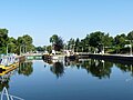
The Plötzensee lock ( ) is a ship lock at kilometer 7.45 of the Berlin-Spandau shipping canal in Berlin. It is located in the district of Charlottenburg-Nord in the Berlin district of Charlottenburg-Wilmersdorf . The double-chamber lock connects the higher water level of the Oberhavel and the Berlin-Spandau shipping canal with the lower water level of the Spree between the Mühlendammschleuse and the Charlottenburg lock . It divides the waterway into an approximately eight kilometer long Havel and an approximately four kilometer long Spree section. The southern chamber of the lock is not in operation (2020). The Berlin Waterways and Shipping Office is responsible for operation and maintenance .
history
Towards the middle of the 19th century, as a result of the economic boom in the region, a direct waterway connection between the then still independent cities of Berlin and Spandau became more and more urgent. Various reasons, such as difficult for a boat trip on the unregulated Unterspreewald before the barrage and the floodgates Charlottenburg were built, and the desire for a shortening of the track to Finowkanal and Or led from 1847 to 1859 for the construction of the then Spandau Canal called Waterway. The traffic between Berlin and the eastern parts of Prussia in the direction of the Finow Canal should be facilitated. The newly created direct canal connection shortened the route by around six kilometers by bypassing the winding lower course of the Spree . The 12.20 kilometer long shipping canal, which had essentially the same cross-sectional design as the Landwehr Canal, which was opened in 1850 , was designed for Finow custom-made ships with dimensions of 40.20 meters in length and 4.60 meters in width and a load capacity of up to 170 tons. These dimensions were ultimately given by the dimensions of the locks on the Finow Canal .
First lock
The first Plötzensee lock was located at kilometer 7.99 ( 52 ° 32 ′ 27.6 ″ N , 13 ° 19 ′ 50.2 ″ E ) of the newly created waterway connection between the Spree and Havel, west of the Seestrasse Bridge (from 1859 Northern Seestrasse Bridge ) . The lock chamber was built as a tow lock for Finow Maß with staggered heads 47.50 meters long and 6.04 meters wide. The chamber itself was about ten meters wide, so that two boats could be sluiced at the same time.
Normally, the water level of the upper Havel drainage dammed up at the barrage of the Spandau lock is higher than that of the Spree. At that time, in flood situations, the water level of the unregulated Lower Spree, the lock and the weir Charlottenburg did not yet exist, was higher than the Havel water level in the position of the Oberhavel. For this reason, the first Plötzensee lock received bidirectional stem gates for its chamber , double stem gates with opposing caulking in order to be able to fend off both the Havel and the Spree. After the regulation of the Lower Spree and the construction of the weir and the locks in Charlottenburg in 1882/85, this safety measure could be dispensed with, so that the opposing double gates were no longer required.
Construction of the lock
With a royal ordinance of 1906, a royal main building authority based in Potsdam was set up for the construction of the large shipping route Berlin-Stettin . The official start of construction for the large shipping route took place on September 19, 1906 with the first groundbreaking on the cut from Criewen to Schwedt . In addition to Plötzensee and Spandau , the lock systems there from the 19th century had to be replaced by a double lock in Plötzensee and a single-chamber lock in Spandau for 600-ton ships. An additional breakthrough to the Charlottenburg connecting canal was made to the south, spanned by the bridge known as the Southern Seestrasse Bridge. The puncture will later be called the West Harbor Connection Canal.
The new double-chamber lock Plötzensee was opened for shipping in 1912. The chambers were given a usable length of 67.20 meters, a width of 10.00 meters and a jamb depth of 3.00 meters , adapted to the Plau custom -made ship. The structure was founded on wooden piles. The sole was made from a large, permeable pavement. Chamber walls and lock heads were built from concrete and partly clinkered. Around 1927 the wooden gates were replaced by steel gates.
Pictures and cards

Bidirectional mortise gate, example image

Waterways in Berlin around 1855

Location of the first Plötzensee lock

Plan of the west port with a new branch canal under the southern sea road bridge
South chamber on the left, north chamber on the right, underwater on the west harbor side

Stemmtor north chamber to the underwater

Folding gate north chamber to the upper water


.jpg)
.jpg)
.jpg)
literature
- Werner Natzschka: Berlin and its waterways. Duncker & Humblot, Berlin 1971, ISBN 3-428-02374-9 .
- H.-J. Uhlemann: Berlin and the Märkische waterways . DSV-Verlag, Hamburg 1994, pp. 115-118, 138 ISBN 3-344-00115-9 .
- Writings of the Association for European Inland Shipping and Waterways e. V. WESKA (Western European Shipping and Harbor Calendar), Binnenschifffahrts-Verlag, Duisburg-Ruhrort. OCLC 48960431
- Dr.-Ing. Rudolf Schwab, Dr.-Ing. Wolfgang Becker: Yearbook of the Port Technical Society, volume forty-second, 1987 . Springer-Verlag, Berlin, Heidelberg 1988, ISBN 3-540-18815-0 .
cards
- Folke Stender: Editing of Sportschifffahrtskarten inland 1. Nautical publication Verlagsgesellschaft, ISBN 3-926376-10-4 .
- W. Ciesla, H. Czesienski, W. Schlomm, K. Senzel, D. Weidner: Shipping maps of the inland waterways of the German Democratic Republic 1: 10,000. Volume 4. Editor: Waterways Authority of the GDR, Berlin 1988, OCLC 830889996 .
Web links
- Plötzensee lock WSA Berlin (PDF file) accessed on February 5, 2020