
Cöpenicker lock
| Cöpenicker lock | ||
|---|---|---|
 Cöpenicker Schleuse on a map from 1910 |
||
| location | ||
|
||
| Coordinates | 52 ° 30 '29 " N , 13 ° 25' 41" E | |
| Place: | Berlin | |
| Waters: | Luisenstadt Canal | |
| Water kilometers : | km 2.050 | |
| Data | ||
| Construction time: | 1848/1852 | |
| Start of operation: | 1852 | |
| Shutdown: | Early 1920s | |
| lock | ||
| Type: | Inland lock | |
| Usable length: | approx. 44 m | |
| Usable width: | approx. 5 m | |
| Average height of fall : |
approx. 0.2 m | |
| Upper gate: | Miter gate , | |
| Lower gate: | Miter gate , | |
| Others | ||
| Associated weir: | no defense | |

The Cöpenicker lock was a lock on the Luisenstadt Canal in Berlin's Luisenstadt . It connected the higher water level of the Oberspree with the lower water level of the Luisenstadt Canal. The Cöpenicker lock was about 2.05 km from the Luisenstadt Canal near the junction from the Spree .
history
In the 1840s, shipping in the greater Berlin area developed rapidly, so that the barges at the city lock in the Spree Canal sometimes had to wait six to eight days for the lock. The Mühlendamm in the Spree prevented a continuous use of the Spree for shipping. A bypass became necessary so that the Landwehr Canal and the Luisenstadt Canal were planned and implemented. The Luisenstadt Canal branches off from the Spree at the Schilling Bridge. Above and below the Schilling Bridge there was a bridge passage under the twin bridge to a canal widening, similar to a water basin. Two streets led around the water basin south of the bridge on either side. The lock was located between this basin and Köpenicker Strasse .
The Cöpenicker lock was built from 1848 to 1852 as a single-aisle lock without a flooding device. The chamber length was about 44 meters and the chamber width about 5.50 meters. It was passable for ships to a maximum of Finow size. The lock walls were made of bricks and the gates were made of oak. Granite was used for the turning niches. The Cöpenicker Bridge crossed the canal on the south side of the lock . This road bridge, which began at the Cöpenicker Tor of the old city wall, led the Cöpenicker Straße from Cölln to Cöpenick near Berlin.
Due to the scarce shipping traffic and the small height difference between the Spree and the canal and a flood which was not planned when the lock was built, the water was in the canal, which led to strong odor nuisance for the population. For these reasons, the Berlin magistrate decided on January 16, 1926 to shut down and demolish the lock and to have the canal backfilled.
Pictures and cards

Waterways in Berlin around 1855

Course of the former Luisenstadt Canal in today's street scene
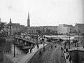
Schilling Bridge and Twin Bridge, cut in the foreground

Former upper entrance (bridge arch) towards the lock under the twin bridge

Former lower entrance towards the lock under the twin bridge


.jpg)
.jpg)

literature
- Werner Natzschka: Berlin and its waterways. Duncker & Humblot, Berlin 1971, ISBN 3-428-02374-9 .
- Klaus Duntze: The Luisenstadt Canal. Berlin Story Verlag, Berlin 2011, ISBN 978-3-86368-014-5 .
- Dr.-Ing. Rudolf Schwab, Dr.-Ing. Wolfgang Becker: Yearbook of the Port Technical Society, volume forty-second, 1987 . Springer-Verlag, Berlin, Heidelberg 1988, ISBN 3-540-18815-0 p. 8.
- H.-J. Uhlemann: Berlin and the Märkische waterways . DSV-Verlag, Hamburg 1994, ISBN 3-344-00115-9 , pp. 98-101.
Web links
Individual evidence
- ↑ See map section.
- ↑ Thiemann, Deczik, Metzing: Berlin and its bridges . In it: Disappeared Bridges , p. 174ff. Jaron-Verlag, 2003, ISBN 3-89773-073-1 .