
Spree Canal
|
Spree Canal Kupfergraben |
||
 Spree island with Spree Canal (left) and Spree (right) |
||
| Data | ||
| location | Berlin , Germany | |
| River system | Elbe | |
| Drain over | Spree → Havel → Elbe → North Sea | |
| Beginning | on the left side of the Spree 52 ° 30 ′ 51 ″ N , 13 ° 24 ′ 41 ″ E |
|
| muzzle | In the Spree coordinates: 52 ° 31 '20 " N , 13 ° 23' 36" E 52 ° 31 '20 " N , 13 ° 23' 36" E
|
|
| length | approx. 2 km | |
| Navigable | not consistently for recreational boating locked |
|
 View from the castle bridge in southeast direction. To the left of the lock bridge is the State Council building on Schloßplatz |
||
 Northern tip of the Museum Island with the Bode Museum and the two parts of the Monbijou Bridge . Right the mouth of the Spree Canal |
||
The Spree Canal (official abbreviation SpK ) in Berlin belongs to the Spree-Oder-Wasserstraße (SOW). Over the centuries the Cöllnischen Stadtgraben developed into today's, around two kilometers long, artificial waterway , which is managed by the Berlin Waterways and Shipping Office .
The importance of the Spree Canal and the city lock that lies along it for inland navigation on the Spree declined from 1894 with the opening of the Mühlendamm lock until the city lock was finally shut down in 2000. The canal is closed to recreational shipping and is no longer navigable due to the Kupfergraben weir .
In Berlin vernacular , the entire Spree Canal is often referred to as the Kupfergraben, although officially only the northern section bears this name.
history
The course of the river Spree was impassable for ships and rafts with the Mühlendamm built between 1220 and 1230 . With the increase in trade and traffic on the water, the former Cölln town moat , a branch of the Spree, was expanded and provided with a sluice. This first wooden lock "on the Werder", the later city lock, was built in 1578 and was later expanded several times. The high level of industrialization in the German Empire required ever larger ships and the city lock was enlarged one last time in 1885. At that time it was already being referred to as the bottleneck in Berlin shipping.
The Spree Island is surrounded by the Spree Canal and the Spree. Sections of the Spree Canal are called today as follows:
- Friedrichsgracht (next to the Friedrichsgracht street ) from the Inselbrücke at the Märkisches Museum to the Gertraudenbrücke
- Schleusengraben from the Gertraudenbrücke to the Schleusenbrücke at Werderschen Markt
- Kupfergraben (next to the street Am Kupfergraben ) from the Iron Bridge behind the Zeughaus to the confluence with the Spree at the northern tip of the Museum Island
course
The Spree Canal branches off the Spree-Oder-Wasserstraße (SOW) on the left at kilometer 17.90 just before the Mühlendamm lock from the Berlin Spree. It remains south of the Fischerinsel and then runs almost parallel to the Märkisches Ufer street in the direction of Spittelmarkt , past the Schloßplatz , Zeughaus and Lustgarten . At the Bode Museum on Museum Island, it flows back into the Spree immediately below the Monbijou Bridge at kilometer 16.31 of the SOW.
bridges
Twelve bridges cross the Spree Canal.
| Name of the bridge | photography | Remarks | Coordinates | ||
|---|---|---|---|---|---|
|
|
|||||
| Island bridge |

|
The Inselbrücke in the course of Inselstraße has been a connection between New and Old Cölln since the 17th century and is located in the catchment area of the historic Berlin port. In the direction of the current, it is the first bridge to the Spreeinsel, known here as Fischerinsel . Today's stone vaulted bridge dates from 1912–1913, built according to plans by Ludwig Hoffmann and city planner Friedrich Krause, and is a listed building . On July 19, 1994, the name of the Inselbrücke (number 44670) was changed to "Inselbrücke (Spree Canal)" (17003) in the official register. | cards | ||
| Rossstrasse Bridge |

|
The Roßstrasse Bridge was initially called the Köpenicker Bridge. Today's Roßstrasse Bridge was built from stone between 1899 and 1901. After severe damage in the Second World War , it was rebuilt in a simplified manner. It connects the Fischerinsel with the historic Neu-Cölln district and has been a listed building since the 1970s. | cards | ||
| Grünstraßenbrücke |

|
The Grünstraßenbrücke was built between 1903 and 1905 as a replacement for a wooden yoke bridge with flaps for shipping. After being severely damaged at the end of World War II and subsequent repairs, it has been on the Berlin list of monuments since the 1970s. | cards | ||
| Gertraudenbrücke |

|
Two structures are called Gertraudenbrücke: the stone Gertraudenbrücke built at the end of the 19th century and the steel girder car bridge built in 1977 for Gertraudenstraße , which as part of Bundesstraße 1 forms a heavily frequented traffic artery between Potsdamer / Leipziger Platz and Alexanderplatz . | cards | ||
| Maiden Bridge |

|
The Jungfernbrücke was built in 1798, making it the oldest bridge in Berlin. At the same time, it is the only surviving of the nine identical bascule bridges over the canal. It connects Unterwasserstraße with Friedrichsgracht street via the Schleusengraben (Spree Canal) . | cards | ||
| Lock bridge |

|
The lock bridge north of the old city lock connects the Werderscher Markt with the Schloßplatz . It is a listed building . | cards | ||
| Castle Bridge |

|
The Schloßbrücke is at the eastern end of Unter den Linden . In the course of the two federal highways B 2 and B 5 it connects Friedrichswerder with Schloßplatz on the Spree island . The formerly wooden dog bridge was replaced by the massive castle bridge between 1821 and 1824 based on a design by Karl Friedrich Schinkel . From 1951 to 1991 it was called the Marx-Engels Bridge . | cards | ||
| Iron bridge |
 
|
The Iron Bridge connects the northern part of the Spree Canal via the Kupfergraben , Bodestrasse (formerly Museumstrasse) with the street Hinter dem Gießhaus. The single arch bridge was completed in 1916. | cards | ||
| Pergamon footbridge |

|
Pedestrian bridge in the area of the Pergamon Museum . | cards | ||
| Light rail bridge |

|
It leads the route of the Berlin light rail over the Kupfergraben. Between the Bode and Pergamon Museum , the route continues over a bridge over the Spree to Hackescher Markt train station . | cards | ||
| Southern Monbijou Bridge |

|
The Monbijou Bridge was built between 1902 and 1904 and consists of two parts: the southern one over the Kupfergraben connects the street Am Kupfergraben with the northern tip of the Museum Island ; the longer northern section leads over the Spree to Monbijoustraße in the Spandauer Vorstadt . | cards | ||

- Pictures and cards
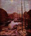
Friedrichsgracht by moonlight ,
painting by Adolph von Menzel

.jpg)

literature
- Hans-J. Uhlemann: Berlin and the Märkische waterways . transpress Verlag Berlin, various years, ISBN 3-344-00115-9 .
- Writings of the Association for European Inland Shipping and Waterways e. V. , various years. WESKA (Western European Shipping and Harbor Calendar), Binnenschifffahrts-Verlag, Duisburg-Ruhrort.
- Folke Stender (Red.): Sports boat tickets inland 1 . Nautical Publication Verlagsgesellschaft, ISBN 3-926376-10-4 .
- W. Ciesla, H. Czesienski, W. Schlomm, K. Senzel, D. Weidner (collective of authors): Shipping maps of the inland waterways of the German Democratic Republic 1: 10,000 , Vol. 4. Publisher: Wasserstraßenaufsichtsamt der DDR, Berlin 1988.
- Eckhard Thiemann, Dieter Desczyk: Berlin bridges: design and jewelry . Lukas Verlag, 2012, ISBN 978-3-86732-099-3 .
- F. Krause, F. Hedde: The bridge construction of the city of Berlin since 1897 . In: Journal of Construction . Edition 72, 1922, issue 1–3, p. 13 ff.
Web links
Individual evidence
- ↑ Directory E, Ser. No. 55 of the Chronicle ( Memento of the original from July 22, 2016 in the Internet Archive ) Info: The archive link was inserted automatically and has not yet been checked. Please check the original and archive link according to the instructions and then remove this notice. , Federal Waterways and Shipping Administration
- ↑ a b Lengths (in kilometers) of the main shipping routes (main routes and certain secondary routes) of the federal inland waterways. ( Memento of the original from January 21, 2016 in the Internet Archive ) Info: The archive link was inserted automatically and has not yet been checked. Please check the original and archive link according to the instructions and then remove this notice. Federal Waterways and Shipping Administration
- ↑ Entry in the Berlin State Monument List with further information
- ↑ Entry in the Berlin State Monument List with further information