
Magdeburg waterway intersection

The Magdeburg waterway junction is located north of Magdeburg , in the Hohenwarthe district of the Möser community . It is the crossing of the Mittelland Canal over the Elbe .
history

The plans for the construction of the waterway cross go back at least to the beginning of the 20th century. The construction of the Mittelland Canal began in 1905. The Rothensee ship lift was completed in 1938 . The canal bridge and the Hohenwarthe double ship lift were also under construction. The abutments , the pillar foundations and four arches of the canal bridge were largely completed when construction stopped in 1942 due to the Second World War . After the end of the war, however, the GDR did not continue the project because, on the one hand, there was no great interest in an east-west connection and, on the other hand, the expenditure on material and labor would have been too high. The bridge abutments stood on both banks of the river for over 60 years. The old parts of the bridge could only be blown up with a lot of effort, as their solidity was much higher than expected.
After reunification, efforts were again made to raise the level of navigation in the east to the level in the west. One of the largest projects was the planned expansion of the waterway connection from Hanover via Magdeburg to Berlin. The Magdeburg canal bridge over the Elbe was completed in 2003 with the German Unity Transport Project No. 17 . The Rothensee lock, built in 2001, has since replaced the outdated ship lift.
The section of the Mittelland Canal from Magdeburg to the Dortmund-Ems Canal has been continuously navigable since the end of 2017 with 185 m long and 2.80 m unloaded push convoys with 3600 t of cargo. VDE 17 should be completed in 2019.
Components of the waterway cross
The Magdeburg Canal Bridge is the center of the Magdeburg waterway intersection . It leads the Mittelland Canal across the Elbe . To the east of the Elbe, the Mittelland Canal merges into the Elbe-Havel Canal .
There are also descent structures: the Rothensee ship lift and the parallel Rothensee sluice lock (opened in 2001), via which the ships can change from the Mittelland Canal to the Elbe. On the eastern side of the Elbe, the Niegripp lock , for the connection Elbe - Elbe-Havel Canal, and the Hohenwarthe lock (opened in 2003), to compensate for the height difference between the two canals, belong to the waterway intersection near Magdeburg.
Until the opening of the canal bridge and the double lock in October 2003, ships wanting from the Mittelland Canal to the Elbe-Havel Canal or vice versa had to take a twelve-kilometer detour via the Rothensee, Elbe and Niegripp locks. The different water levels between the Mittelland Canal and the Elbe and the associated different diving depths of the watercraft were problematic. While a depth of around 2 m is possible in the Mittelland Canal, the value in the Elbe fluctuates between 1.30 m and 1.50 m. The result was that ships with a greater draft than possible in the Elbe had to be lightened into the Magdeburg harbor. Part of the cargo was transported by a second ship to the Elbe-Havel Canal and reloaded there again.
The connecting canal between the canal and the Elbe is called the Rothenseer connecting canal . It has a direct connection to the Magdeburg inland port via the Magdeburg canal and forms part of the port with its own port facilities (which will be expanded from 2004). The Magdeburg low water lock, which opened in 2013, is located between the descent canal and the Elbe so that the port of Magdeburg remains navigable by ships from the canal even when the water on the Elbe is low .

Trough bridge during construction
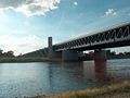
Trough bridge of the waterway cross over the Elbe

Above: Mittelland Canal; below: Elbe

On the canal bridge

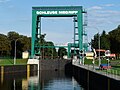
Rothensee savings lock

Hohenwarthe lock
Niegripp lock

Magdeburg low water lock


.JPG)
.JPG)
Use of the waterway intersection

The construction of the trough bridge and the Hohenwarthe lock was based on forecasts by Planco Consulting . After the completion of the waterway cross, these foresaw an increase in freight transport on the Mittelland Canal, Elbe-Havel Canal and Elbe by around 600%. The figures forecast for the trough bridge were later corrected downwards several times. In 2010, the actual volume of traffic on the canals was around 10 percent and on the Elbe around 5 percent of the forecast values and, with the exception of the Mittelland Canal, is still below the traffic figures before the construction of the waterway intersection.
Originally, it was planned to operate the Hohenwarthe lock and the Rothensee ship lift as part of the waterway intersection. It was intended that “ the Rothensee ship lift will continue to operate parallel to the modern system after the new lock has gone into operation ”.
Among other things, the ship lift is the only means of transport for smaller pleasure craft that are not allowed to enter the Hohenwarthe lock and the trough bridge due to the possible dangers of water turbulence. In addition, the ship lift works much more energy-efficiently than the lock, where 40 percent of the lock water requirement has to be pumped from the lower to the upper water level. This makes it an alternative to the lock for ships up to 85 meters in length and two meters in draft. In contrast to the plans, the operation of the ship lift was discontinued in 2006 due to a lack of profitability at the insistence of the Federal Audit Office . In August 2013 it was reopened for tourism purposes.

Waterway Cross in Culture
In the 2011 film Who is Hanna? the waterway cross serves as a backdrop in one scene.
See also
literature
- Karl Jüngel, The waterway cross near Magdeburg , 16 pages, 2004
Web links
- Waterway cross at the new waterway construction office in Magdeburg
- Jörg Schönebaum: private website for the Magdeburg waterway intersection
- Brochure from the Magdeburg Waterway Construction Office ( Memento from July 28, 2007 in the Internet Archive ), (PDF file, approx. 2.4 MB)
swell
- ↑ Magdeburg Waterways Construction Office: Magdeburg waterway intersection. Magdeburg, September 1999. p. 3
- ^ Federal Waterways and Shipping Administration: Traffic Report 2010 of WSD Ost. Magdeburg, 2011 ( Memento of the original from February 2, 2014 in the Internet Archive ) Info: The archive link was inserted automatically and has not yet been checked. Please check the original and archive link according to the instructions and then remove this notice. (PDF; 2.3 MB)
- ↑ The history of building the Elbe. (No longer available online.) In: BUND-Flussbüro. Association for the Environment and Nature Conservation Germany V. (BUND), archived from the original on September 9, 2012 ; accessed on November 28, 2015 .
- ↑ Magdeburg Waterways Construction Office: Magdeburg waterway intersection. Magdeburg, June 2002. p. 11.
- ↑ Martin Rieß: The Rothensee ship lift goes back into operation at the end of August . In: Volksstimme . Magdeburg July 19, 2013 ( online ( memento from January 18, 2015 in the Internet Archive ) [accessed on November 28, 2015]). The Rothensee ship lift will go back into operation at the end of August ( memento of the original from January 18, 2015 in the Internet Archive ) Info: The archive link was automatically inserted and not yet checked. Please check the original and archive link according to the instructions and then remove this notice.
Coordinates: 52 ° 13 '51.2 " N , 11 ° 42' 4.8" E