
Minden waterway intersection


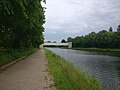
The Minden waterway intersection is a crossing of two waterways in Minden, East Westphalia . Here is the Midland Canal since 1915 in a trough bridge over the Weser valley and around 13 m below flowing from south to north Weser out.
Since 1998, ship traffic has been running over the new bridge that was built in parallel. Both canal bridges bridge the river and the Weser meadows with a length of 370 m and 398 m respectively. This allows 174 km of free travel for shipping on the canal, which otherwise would have to overcome this cut in the terrain with locks.
The Mittelland Canal is connected to the Weser via two connecting canals with locks, which enable shipping to switch between the two waterways. The Minden Waterways and Shipping Office is responsible for the Mittelland Canal, Weser and the two connecting canals .
In addition to the cross in Minden, there is the Magdeburg waterway cross along the Mittelland Canal . Both are the only waterway crosses with trough bridges in Germany . Trough bridges are very common in the area of German waterways. However, if such bridges cross a watercourse that is not or no longer navigable, for example the Leine at Seelze, it is not a waterway cross either .
history
The Prussian state saw the end of the 19th century the need for a waterway connection between Rhine , Weser and Elbe and a west-east waterway north the mountain range to create. Ministerial Director and hydraulic engineer Leo Sympher was commissioned to take over the planning. As a result, on April 1, 1905, the law for the construction of the Mittelland Canal under the then name "Rhein-Weser Canal" was passed from Dortmund-Ems Canal in the west to Hanover in the east. The construction was completed by 1916 despite considerable difficulties in the First World War . On December 5, 1920 it was decided to continue the canal eastwards to the Elbe. In addition to the economically necessary inland waterway, the procurement of work in an economically difficult environment increasingly played a role in planning and construction. Leo Sympher retired from active service at this point.
The first bridge, opened in 1915, was supplemented in 1998 by a second bridge with a larger profile to allow passage for the new, larger large motor ships . From this point on, the old bridge is only used by sport boats. Commercial shipping traffic will only take place over the new bridge. The city of Minden entered the old canal bridge in their list of monuments in 1987 as a monument that characterizes the cityscape .
geography

Since the western end of the Mittelland Canal between the Dortmund-Ems Canal at Bergeshövede and the Anderten lock in Hanover has a constant water level, the 174 km long lock-free route had to be routed over all uneven terrain. This was usually achieved by building dams and cutting into the landscape. Only the Weser Valley near Minden and the Leine Valley near Seelze required an expanded structure. In addition, the transfer of one waterway over another waterway and the connection between them had to be made possible in Minden . In Minden, the Mittelland Canal is therefore led in trough bridges over the Weser. The profile of the bridges corresponds to the rectangular profile of the canal. The water level of the canal is around 13 m above the Weser water level and around 10 m above the site.
Bridge structure
The bridges of the Minden waterway intersection span the actual Weser valley and thus enable the water level of the Mittelland Canal to remain constant across the valley. The old bridge that was initially built has now been replaced by a new bridge and is only used for recreational shipping. The entrances are blocked by transversely anchored barges. The official route can still be used by people and cyclists.
Old bridge

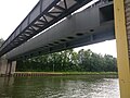
The canal bridge was completed in 1914 after 33 months of construction under the direction of engineers Heinrich Küster and Gereke. The bridge is m long and 370 in a massive structure made in concrete. It is sealed with asphalt cardboard, which is protected with a two millimeter thick lead skin. Above that there is a 10 centimeter thick layer of clay, which in turn is protected by 10 centimeter thick reinforced concrete slabs. The bridge trough of the old bridge has a water level width of 24 m and a water depth of 3 m. The side of the trough is supplemented by a service route that is laid in the side parts of the bridge. It could be used by pedestrians as a public service route, but is no longer accessible to the public. To view the trough, there is a service path in the side part of the bridge that receives light through openings in the wall. The canal bridge spans the Weser with two arches. The boat trip on the Weser uses the eastern of the two arches. Six further arches are available for the flood discharge, so that there can be no water stagnation even in extreme floods . The six flood openings have a span of 36.50 m each and the two stream openings have a span of 54.44 m each. The bridge structure is clad with basalt lava in the area of the pier bases, while the pier heads, the arches, the service parapets and the stair towers were clad with reddish sandstone slabs from the Rhine Palatinate. The bridge bearings on the bank are flanked by square towers that contain a staircase.
During the Second World War , the bridge was blown up on April 4, 1945 by the German troops retreating to the east bank. As a result, the two river arches collapsed into the Weser and the main pillar was damaged. The canal was only partially empty through the quickly closed security gates. The areas below were flooded. The Weser was dammed due to the debris lying in the water and flowed through the flood arches. In order to channel this water pressure and to enable emergency passage for the Weserschifffahrt, a flood channel was dug through the flood arches that had remained in front of it to the west. This made it possible to restore shipping traffic on the Weser. After the bridge's fracture point had been sealed, shipping was resumed on the Mittelland Canal with the help of the north and south descent. The destroyed bridge was rebuilt in reinforced concrete in 1947-49. In April 1949 the repaired canal bridge over the Weser was opened to traffic again. Remnants of the flood channel were used as a marina for decades . The bridge was entered in the list of monuments of the city of Minden in 1987 and thus classified as an architectural monument .
New bridge


Since the old canal bridge is not sufficiently large for the traffic of large motor cargo ships , a new canal bridge was built as part of the Mittelland canal expansion from October 1993 as part of a so-called second voyage over the Weser. The dimensions of the new bridge were determined by the required cross-section dimensions of the bridge trough of 42 m water level width and 4 m water depth and compliance with a clearance profile for Weser shipping (30 m width, 4.50 m clearance height). This allows ships with one meter more draft to pass the bridge and also meet.
The new canal bridge was built north of the old bridge with a center distance of 50 m. The pillars of the new canal bridge are in line with the pillars of the old bridge in order to guarantee an unhindered flood discharge of the Weser.
A rectangular steel channel trough 341 m long was chosen for the superstructure. It bridges the six flood openings with spans of 36.50 m each and the two river openings with spans of 54.44 m each. The total length of the structure is 398 m. The steel structure with a mass of 7800 t was prefabricated in 234 parts in the manufacturing plant. The total of 18 shots were delivered to the construction site in 13 parts, mostly by barge , aligned and welded on an assembly platform and installed from west to east using the incremental launching method . The construction costs amounted to around 85 million DM. The bridge was opened on August 25, 1998 by the then Federal Transport Minister Matthias Wissmann .
Connection canal north to the Weser

The connecting canal north to the Weser (VKN) (north descent) at the Minden waterway junction provides the shortest connection west of the canal bridge between the Mittelland Canal at km 101.6 and the left bank of the Weser at km 206.3. It is 1.2 km long and allows access to the port of descent, at the end of which is the construction port. It belongs to waterway class IV .
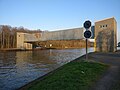
Minden shaft lock
The shaft lock overcomes the height difference of around 13 m between the Mittelland Canal and the Weser . It was built between 1911 and 1914 as a solid structure with a usable chamber length of 82 m and a width of 10 m .
In order to keep water consumption as low as possible, 16 closed savings basins were arranged on both sides of the lock chamber in four levels, one above the other. These saving basins can hold 7,300 m³ of the water from the lock chamber. During the downward lock, 4,000 m³ are released to the Weser; in the case of upward locks, these 4,000 m³ must be removed from the canal. With the changing water levels of the Weser, the maximum drop height of the lock is 13.20 m. It takes an average of seven minutes to fill or empty the chamber. The lower gate of the lock is a lifting gate. It has a weight of 63 t and is designed as a welded steel construction. The counterweights of the gate are located in the characteristic lifting towers at the bottom of the lock. The upper gate is a folding gate and designed as a riveted steel construction.
In 1988/89, after more than 70 years of operation, the shaft lock was completely repaired. Here, among other things, the redesign of the carried Oberhauptdrempels , was enlarged m so that the effective length of the lock chamber on the 85th This means that European ships can use the lock. The construction costs for the basic repairs amounted to 10.4 million DM.
Weser lock Minden
As part of the expansion plans for the Mittelweser to include the new size class of large motor freight ships (length 110 m) , the north descent is also to be adapted to this ship size. For this purpose, the shaft lock will be supplemented by the Weserschleuse Minden, which runs parallel to the east, or will later be replaced by it. In 2009, construction work began on the new lock. According to initial plans, the 139 m long and 12.50 m wide lock should be completed in 2015, construction was then delayed until 2017. After six months of trial operation, the lock was put into operation in spring 2017.
The Weserschleuse uses 25,000 m³ of water for one lock, the water consumption is to be reduced by more than 60 percent through open savings basins.
The shaft lock, which was built at the beginning of the 20th century, is to continue to be operated for the time being after the Weserschleuse has been opened, as it also consumes less water due to its smaller size and is therefore more economical to operate.
Connecting canal south to the Weser
The 1.3 km long connecting canal south to the Weser (VKS) (south descent) also connects the Mittelland Canal at km 102.9 and the Weser at km 204.5 with two locks on the right bank of the Weser. He belongs to the waterway class IV. Between the two locks located industrial port Minden and in the confluence area of the Weser the old Weser port with the now economically discontinued Weser shipyard .
Upper lock
Simultaneously (1911–1914) with the shaft lock and the old canal bridge, the upper lock was built at VKS-km 0.2. It has a usable chamber length of 82 m and a chamber width of 10 m. The height difference between the Mittelland Canal and the industrial port is 6 m. In 2004 there were 2,178 people smuggled . The water requirement for one lock filling is 5,400 m³.
Lower lock

The lower lock at VKS-km 1.0 with an open savings basin was built in the years 1921–1925. It has a usable chamber length of 82 m and a chamber width of 12.50 m. The greater width should give the paddle steamers, some of them 12 m wide, on the Weser a better opportunity to reach the industrial port. The height difference between the industrial port and the Weser is up to 7.08 m, depending on the water level of the Weser. In 2004 there were 2,171 people smuggled. The water requirement for filling the lock is 8,400 m³.
Industrial port
The two locks of the southern descent are connected by an urban industrial port encompassing two basins with a railway connection and the southern connecting canal.
The docks were built at different times. While the upper basin went into operation at the same time as the upper lock in 1915, the lower basin was not opened to traffic until 1967. Lately attempts have been made here to achieve better shipping of goods to the Mittelweser by means of a container terminal . This succeeds relatively successfully, since Minden is to be regarded as the hinterland to the seaports with inland vessels operating according to weekly timetables due to the expansion of the Mittelweser. There are also plans for a new container port on the eastern outskirts of Minden on the Mittelland Canal, the so-called RegioPort Weser .
Pumping stations

Water is continually withdrawn from the sewer through evaporation , seepage, lock operation and the withdrawal of consumption water. It must therefore be fed with water from rivers via pumping stations . In the area of the Minden waterway intersection, there is a main and an auxiliary pumping station, each located on one side of the trough bridge.
The main pumping station
The area of the Mittelland Canal from the Anderten lock to the junction from the Dortmund-Ems Canal is mainly supplied with water from the Weser by the Minden main pumping station. The main pumping station was built between 1912 and 1914 and then inaugurated. It is on the left bank of the Weser and south of the canal. In addition to feeding the Weser water into the Mittelland Canal, electricity is generated by draining excess water into the Weser. Half of the electricity generated in this way (a total of around 500,000 kWh per year) is used for the buildings of the waterway intersection.
The main pumping station is originally supplied by a direct power line from the hydroelectric power station of the Dörverden barrage.
From 1995 to 1999 the main pumping station was completely overhauled. Every year around 58 million m³ of water are pumped. The delivery rate is 16 m³ / s.
The auxiliary pumping station
The auxiliary pumping station in Minden is located on the right bank of the Weser and was built between 1911 and 1914. The delivery rate is 4 m³ / s. Since the water requirement of the Mittelland Canal is normally covered by the main pumping station, the auxiliary pumping station is only required to supplement the pumps of the main pumping station or to supply the eastern part of the Mittelland Canal to Hanover with water when the canal bridge is drained. With the construction of the second canal bridge, the flow across the bridge has now been increased so that the auxiliary pumping station is no longer necessary.
validation
To secure the canal, there is a gate to the west and east so that the canal can be sealed off if necessary or in emergencies. The western gate is in Hahlen , the eastern one in Dankersen . The locking gates each need six minutes to open or close normally; in an emergency, the locking gate can be lowered in four minutes, in this case the gate is lowered by its own weight and only braked. The doors are checked for functionality every four weeks in times of low traffic.
Overall, the waterway cross is secured several times: If the bridges are closed, ships up to 80 meters long and 10 meters wide can reach the other side of the canal via the shaft lock, the upper and lower lock. If one of the locks fails, the desired destination (canal, Weser or industrial port) can still be reached using a combination of the other two. With the new construction of the Weser lock, the shaft lock is also redundant.
Hahlen barrier gate from afar
Close-up of the Hahlen barrier gate
Dankersen lock gate


Information center

As part of its public relations work, the Minden Waterways and Shipping Office operates an information center with an extensive exhibition in the immediate vicinity of the Minden shaft lock. Using text and picture walls, video films, computers and a large number of models, the exhibition provides information about the German waterway network. Part of the exhibition is dedicated to the Minden waterway intersection, the Mittelland Canal and the Weser. The information center is closed in the winter months.
Leo Sympher Monument

Within the facilities of the Minden waterway intersection there is a memorial in front of the information center that commemorates the Prussian ministerial director Leo Sympher . Sympher was born on October 19, 1854 in Hann. Münden was born as the son of a Hanoverian officer and was a civil engineer with a focus on hydraulic engineering. He was significantly involved in the construction of the Kiel Canal and was therefore appointed to the Prussian Ministry of Public Works in 1899 to devote himself to the expansion of the Prussian waterways.
His main work is the planning and execution of the Mittelland Canal as a connection between the Ems, Weser and Elbe on the southern edge of the North German lowlands, in particular the crossroads between the Mittelland Canal and the Weser. Leo Sympher built the Edertalsperre with 202 million m³ and the Diemelalsperre with 20 million m³ in the catchment area of the Weser . In the summer half of the year, these should supply additional water to the Weser as a replacement for the water to be drawn off in Minden to supply the canal and achieve a steady water level in the Upper Weser.
See also
literature
- M. Eckoldt (Hrsg.): Rivers and canals, The history of the German waterways. DSV-Verlag, 1998, DNB 954164873 .
- Wasser- und Schifffahrtsamt Minden (Ed.): The waterway cross Minden. 2nd Edition. Deutscher Kunstverlag, 2009, ISBN 978-3-422-02190-7 .
Web links
- Structures in the area of responsibility of the Minden Waterways and Shipping Office
- Aerial photo of the waterway intersection in Minden and further information on amtage.de
- Visitor route at the Minden waterway intersection with a map
Individual evidence
- ^ Memorandum of the Minden Waterways and Shipping Office on Leo Sympher
- ^ Baukunst NRW: Das Wasserstraßenkreuz Minden , accessed on March 30, 2016.
- ↑ Amtage: Das Wasserstraßenschifffahrtskreuz Minden , accessed on March 22, 2017.
- ↑ Wasserstraßenamt Minden: Structures; the canal bridge. accessed on March 30, 2016
- ^ Baukunst NRW: Das Wasserstraßenkreuz Minden , accessed on March 30, 2016.
- ^ Baukunst NRW: Das Wasserstraßenkreuz Minden , accessed on March 30, 2016.
- ↑ Amtage: Das Wasserstraßenkreuz Minden ( Memento from March 24, 2016 in the Internet Archive ) accessed on March 30, 2016
- ^ Baukunst NRW: Das Wasserstraßenkreuz Minden , accessed on March 30, 2016.
- ↑ IHK study: Economic factor Mittellandkanal and Weser in Minden-Lübbecke ( Memento from August 4, 2016 in the Internet Archive ) accessed on January 3, 2017
- ↑ Amtage: Das Wasserstraßenkreuz Minden ( Memento from March 24, 2016 in the Internet Archive ) accessed on March 30, 2016
- ^ Baukunst NRW: Das Wasserstraßenkreuz Minden , accessed on March 30, 2016.
- ↑ Ibbenbürener Volkszeitung on August 26, 1998: "New bridge over the Weser released"
- ↑ a b Lengths (in km) of the main shipping routes (main routes and certain secondary routes) of the federal inland waterways ( memento from January 21, 2016 in the Internet Archive ), Federal Waterways and Shipping Administration
- ↑ Mindener Tageblatt October 1, 2016: Dry exercises at the new Weserschleuse , accessed on October 8, 2016.
- ^ Baukunst NRW: Das Wasserstraßenkreuz Minden , accessed on March 30, 2016.
- ^ WSA Minden: Pumpwerke , accessed on January 5, 2016.
- ^ Verden district: Dörverden run-of-river power plant , accessed on September 7, 2015.
- ↑ Study of the economic factor Mittellandkanal and Weser in Minden-Lübbecke. P. 20 , archived from the original on March 21, 2017 ; accessed on August 11, 2015 .
- ↑ Information center / shaft lock at wsa-minden.de
Coordinates: 52 ° 18 ′ 11 ″ N , 8 ° 55 ′ 54 ″ E