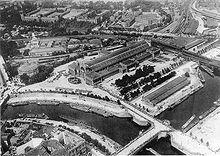
Humboldthafen

The Humboldthafen is a harbor basin in the Mitte district of Berlin . The basin, built according to the plans of the landscape architect Peter Joseph Lenné and named after the natural scientist Alexander von Humboldt , has a water surface of 33,500 m². The water depth is around 3.5 meters. Today the Humboldthafen is a listed building .
location
The funnel-shaped Humboldthafen is located north of the Spreebogen and connects the Spree with the Berlin-Spandau shipping canal . It is located in the immediate vicinity of Berlin Central Station and is crossed in the middle by its tram route / Humboldthafenbrücke . It is bordered by Friedrich-List-Ufer in the west, by Alexanderufer in the east, by Invalidenstrasse in the north and by Hugo-Preuss-Brücke in the south. To the east is the area of the Berlin University Hospital Charité , to the west and north the Bahnhofsviertel and Europacity .
history


In the course of the construction of the Berlin-Spandau shipping canal and the upgrading of the Spreebogen towards the Moabiter Werder and the former powder meadows, the Humboldthafen was also created as a decorative basin between 1848 and 1850. The so-called Hohe Weinberg , which was removed in 1848, was located in the place of the harbor basin . Loading streets and areas for cargo handling were created. The bank walls were built according to plans by landscape architect Peter Joseph Lenné by 1859.
The operation of the port was discontinued after the Second World War , because the Berlin ports were not able to cope with the growing bulk cargo volumes and the Berlin east port and the west port were completed.
Due to the fact that in the years of German division the sector boundary between east and west ran directly on the western bank of the harbor basin, the area fell into a "deep sleep" for decades. On August 24, 1961, Günter Litfin was the first person to be killed on the Berlin Wall while swimming through gunfire.
Initially used as a storage facility after German reunification , the port only returned to public interest in the course of the construction of the new central station. The plans for Berlin's urban development envisage a number of possible uses, ranging from the construction of a marina , an exhibition of historic ships to the construction of piers for tourist steamship travel.
Development
The 3.5 hectare wasteland around the harbor basin is to be built on in the 2010s [obsolete] with residential, office and retail buildings.
As a first measure of the port perimeter development, the bank walls were largely renewed between 2008 and 2013. These are 700 meters long and around six meters high. The load-bearing structure was rebuilt, the cladding with sandstone slabs followed the historical model, with around half of the old slabs being re-used in accordance with the historic requirements. The renewal of the missing sections on the east bank will take place after completion of the construction work for the S21 S-Bahn project . [obsolete] The total cost is around 20 million euros.
Humboldthafen Eins

With Humboldthafen Eins , the first building opened on the southeast corner of the harbor basin in the summer of 2015. Since then, it has housed the Berlin headquarters of the auditing firm PricewaterhouseCoopers and the capital city office of MSD Sharp & Dohme .
The building is characterized by particularly efficient energy management with an integrated combined heat and power unit and heat recovery ventilation systems.
See also
literature
- Peter Neumann: Like in Venice - with the water taxi to work and to the museum . In: Berliner Zeitung , July 6, 2006
Web links
- Entry in the Berlin State Monument List with further information
- Humboldthafen . In: District lexicon of the Luisenstädtischer Bildungsverein
- Portal of the Humboldthafen Eins project company
Individual evidence
- ↑ a b c d Renewal of the bank walls in Humboldthafen completed. Senate Department for Urban Development and the Environment, October 23, 2013, accessed on October 30, 2013 .
- ↑ Manfred Becker: The planning of the powder mill terrain - on the conflict between Lenné and Schinkel . In: Berlin: From the residential city to the industrial metropolis . I. Volume. TU Berlin, Berlin 1981, ISBN 3-7983-0773-3 , p. 453–463 (catalog for the autumn 1981 exhibition).
- ↑ Construction activities of LIP and ABG between 2014 and 2016 on immobilien-zeitung.de
- ↑ Construction project on the edge of the harbor ( Memento from November 1, 2013 in the Internet Archive ) (PDF; 2.5 MB) on liegenschaftsfonds-berlin.de
- ↑ Humboldthafen is to become Berlin's active district
- ↑ Hand over to Humboldthafen Eins
- ^ Courtyard structure at the Humboldthafen
- ↑ Investor OVG hands over the “Humboldthafen Eins” office complex. In: berliner-woche.de , July 13, 2015
Coordinates: 52 ° 31 ′ 32 ″ N , 13 ° 22 ′ 20 ″ E


