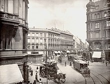
Hackescher Markt
The Hackesche Markt in the Spandau suburb of the Berlin district of Mitte is a traffic junction and a starting point for Berlin's nightlife.
location
The square is located at the southern end of Rosenthaler Straße, where the fortress moat extended into the 19th century . In addition, Oranienburger Strasse , Große Praesidentialstrasse, Neue Promenade and An der Spandauer Brücke run towards the square.
history
The area on which the square is located today was originally marshland. It was only when the moat was demolished that the Berlin city commandant, Count Hans Christoph Friedrich von Hacke, had the square laid out on behalf of Friedrich II . It quickly became known as the Hackesche Markt (until 1872 Haackesche Markt ), but it was not officially named until July 23, 1840.
In the late 19th and early 20th centuries, the square developed into an inner-city hub thanks to public transport . The Berlin Stock Exchange , after which the S-Bahn station on the square was named, was located near the square . During the Second World War , part of the buildings surrounding the square were destroyed. The square, located in East Berlin after the division of Germany and now characterized by vacant lots, lost its importance in the slipstream of the city center at Alexanderplatz , which was rebuilt in the 1960s .
After the reunification of Germany and Berlin in 1990, the existing old buildings were renovated and the vacant lots closed. Most of the square was redesigned as a pedestrian area. At the square and in the viaduct arches of the train station as well as along the roads leading to it, various catering establishments of all kinds have settled, so that the Hackesche Markt advanced to become the starting point of an entertainment district. Today the square is used as a beer garden and a weekly market .
Public transport
tram
Until a few years ago, the square was the central junction of the Berlin tram , today it has to share this position with Alexanderplatz. Four MetroTram lines (M1, M4, M5, M6) from three directions meet at Hackescher Markt, two of which have their terminus here. In night traffic, three of the aforementioned tram lines stop or end here, as the M6 line does not run at night on a large part of the section already served by the M5 line.
The central importance stems from the fact that one of the few inner-city turning loops for the tram is located here . All sections of the route south of the Stadtbahn were shut down by 1970, so that traffic, which usually runs from the outskirts to the city center, automatically meets here.
The Wendeschleife was initially a single-track passage and originally did not serve its current purpose. It was only gradually expanded to four sidings. However, the enormous traffic in the loop can mean that starting trains leave here with a delay. With the construction of a new route across the Alexanderplatz, the turning loop had to be rebuilt, the trains now on a short distance south of the rail - viaduct along to record the new track here.
S-Bahn station
The Berlin S-Bahn station was built by Johannes Vollmer from 1878 and opened to traffic on February 7, 1882. It was then called the stock exchange and was renamed Marx-Engels-Platz on May 1, 1951 . The new name was more or less misleading, because it was in front of the Palace of the Republic , which was built later, and was therefore not in the immediate vicinity of the station, but about 500 meters away. On May 31, 1992, the station was renamed Hackescher Markt after the trams had been serving this destination for years.
Its brick hall for the S-Bahn light rail trains is particularly worth seeing . The long-distance trains are passed south of the hall. There are numerous cafes, bars and restaurants in the arches below the hall and the tracks. The S-Bahn station is now a listed building .
Thanks to the S-Bahn station and the numerous tram lines, the square and the surrounding streets are very well developed. A variety of cinemas, pubs, cafes and retail stores are within easy walking distance. There are hardly any car parking spaces.
night bus
While not a single bus line stops at Hackescher Markt during the day, until December 14, 2019, it was the second most important transfer point in Berlin after the Zoo train station . Then the night notes were relocated to Alexanderplatz, so that now only the N42 is the only night bus that runs through Hackescher Markt.
Surroundings
The area around Hackescher Markt is characterized by numerous sights, cultural institutions and dining facilities. These include the Monbijoupark , the Hackesche Höfe , the Lustgarten with the Berlin Cathedral , the Museum Island , Alexanderplatz and the New Synagogue on Oranienburger Straße . Since the renovation in 2008, the Jewish cemetery , the destroyed area of which the Jewish community received back in 1948, has been recognizable as such again.
literature
- Ralph Hoppe, Wolfgang Feyerabend: Right through the middle - The Spandau suburb . Haude and Spener, 1998, ISBN 3-7759-0425-5 .
- Joachim Seyppel : The Wall or The Café at Hackescher Markt . (Roman) Ullstein, 1997, ISBN 3-548-20368-X .
Web links
- Hackescher Markt. In: Street name lexicon of the Luisenstädtischer Bildungsverein (near Kaupert )
- Entry in the Berlin state monument list for the Hackescher Markt S-Bahn station
- Website from Hackescher Markt Berlin
- Hermann Jansen: Competition Greater Berlin 1910. Hackescher Markt
Individual evidence
- ^ Announcements and Berlin address books until 1872
- ↑ "Nachtknoten is moving" on bvg.de.
Coordinates: 52 ° 31 ′ 24 ″ N , 13 ° 24 ′ 10 ″ E


