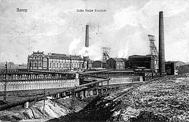
Kaiser Friedrich colliery
| Kaiser Friedrich colliery | |||
|---|---|---|---|
| General information about the mine | |||
| historical postcard view from 1912 | |||
| Funding / year | up to approx. 335,000 t | ||
| Information about the mining company | |||
| Employees | about 1500 | ||
| End of operation | 1925 | ||
| Funded raw materials | |||
| Degradation of | Hard coal | ||
| Geographical location | |||
| Coordinates | 51 ° 28 '13 " N , 7 ° 25' 16" E | ||
|
|||
| Location | Menglinghausen | ||
| local community | Dortmund | ||
| Independent city ( NUTS3 ) | Dortmund | ||
| country | State of North Rhine-Westphalia | ||
| Country | Germany | ||
| District | Ruhr area | ||
The Kaiser Friedrich colliery is a former mine in the Menglinghausen district of Dortmund .
Operating history
The Kaiser Friedrich colliery was founded in 1871 as part of the Bergisch-Märkischer Bergwerks-Verein AG . In 1883 it became part of the Baroper coal mines union together with the Henriette (formerly Sanssouci), Holthausen and Hummelbank collieries . This was dissolved due to bankruptcy in 1887, and in 1888 the Kaiser Friedrich trade union was founded.
At the beginning of the 20th century, the Dortmund Union owned the Kux majority . After taking over the Union, Kaiser Friedrich belonged to the German-Luxemburgish Mining and Hütten-AG from 1910 , which also owned the neighboring mines Wiendahlsbank , Louise Tiefbau and Glückauf Tiefbau .
The highest production was 334,782 tons in 1913 with 1,546 employees. The colliery owned a large coking plant with 200 ovens and from 1913 a benzene factory .
In 1925 the mine fell victim to the great death of collieries in the south of Dortmund and was closed. Only the coking plant remained in operation until 1930; it received the coking coal from the Minister Stein colliery in Eving.
Search for clues
In the street "Am Sturmwald" in Menglinghausen there is still the transformer house of the old colliery, recognizable by the semicircular window arches. Directly south of it, at the corner of "Grotenbachstrasse" and "Am Spörkel", are the remains of the mining dump . There are also remains of the wall that surrounded the area, including an old entrance gate. The so-called "bull monastery" originally stood there and housed workers. The "Harkortshof" street follows the course of the former colliery railway to the neighboring Dortmund-Barop train station . In the residential area to the west there is still the "Zeche-Kaiser-Friedrich-Straße". Some of the girders' foundations are still in place from the cable car that was used to transport materials. One is on a small path that branches off from the "Am Rüggen" road in the direction of the old dump.
From the Henriette colliery you can still see a building (now a residential building) and the shaft cover on "Baroper Straße" in Eichlinghofen.
See also
literature
- Wilhelm Hermann, Gertrude Hermann: The old mines on the Ruhr. 6th edition, updated by Christiane Syré and Hans-Curt Köster. Langewiesche, Königstein im Taunus 2007, ISBN 3-7845-6994-3 .

