
Spandauer Weg
| Spandauer Weg | |
|---|---|
 Fort Hahneberg on the way |
|
| Data | |
| length | 31 kilometers |
| location | Spandau (green main path) |
| Supervised by |
FOOT e. V. BUND-Berlin Citizens' Project "Network" Berliner Wanderverband Stadtentwicklung |
| Markers |
 Blue field, white "2" |
| Starting point | Spandau Aalemannufer in front of the Tegelort ferry pier 52 ° 34 ′ 22.7 ″ N , 13 ° 13 ′ 20.1 ″ E |
| Target point | City boundary between Kladow and Potsdam 52 ° 26 ′ 29.5 ″ N , 13 ° 7 ′ 11.7 ″ E |
| Type | trail |
| Height difference | low |
| Level of difficulty | Forest and riverside path |
| season | all year round |
| Viewpoints | Tower at Laßzinssee ( location ), Hahneberg 87 m above sea level. NN , Karolinenhöhe 52 m above sea level. NN |
| particularities | Hiking trails mainly through woodland on the city limits, Havel bank |
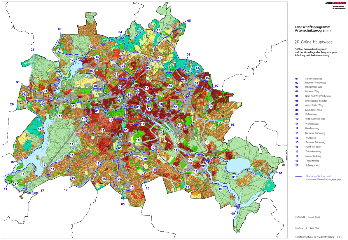
The Spandau way is with the number 02 one of the 20 main routes green . This is a compilation of 20 hiking trails through the Berlin urban area with a total length of around 550 kilometers. The aim is to link “residential areas with the diverse recreational opportunities in parks and local recreation areas in Berlin and Brandenburg ” (Senate Department for Urban Development and the Environment). The pedestrian should have the opportunity to “experience the city intensely as a combination of culture, history and ecology”.
course
The Spandauer Weg leads over a length of 31 kilometers within the Spandau district through the green areas of the Berlin state area west of the Havel. In the west and north on the state border it partially coincides with the Berlin Wall Trail and is supplemented in Hakenfelde by the Havelseenweg (with no. 12), which runs on the west bank of the Havel. A circular route is reached on this through Wilhelmstadt , Pichelsdorf and Weinmeisterhöhe. The Spandauer Weg leads through the former Gatower Rieselfeld area and leads south to Kladow to the steamship landing stage and the ferry F10 . At the district border, the hiking trail is taken up by the Wall Trail (albeit in Potsdam area) on the west bank of the Groß-Glienicker See.
The main path complements the Havelseenweg around Spandau. The description begins at its end point up the Havel and runs counterclockwise around Spandau.
Hook field


An entry point for Hauptweg 02 is on the Aalemannufer at the outlet of the Aalemann Canal into the Havel . The Havelseenweg (path no. 12) leads south on the banks of the Havel and the Spandauer Weg leads north. The main path leads along the Havel via a parking lot near the car ferry to Tegelort (Jörsfelde) and a playground in a green strip of shore on the western edge of the weekend settlement 'Sportverein Aalemann'. The riverside path past a garden path, the Rustweg , a bush zone in front of a fallow area, on the Oberhavelsteg over the Teufelsseekanal , the fallow area of the former Oberhavel power station. The bathing establishment of the Johannesstift away from the Havel immediately past the campsite, the path leads north to the Havel bathing area of the Bürgerablage with water rescue station. Here the Wall Trail meets the Spandauer Weg, which runs westwards to Niederneuendorfer Allee and on this to the city limits. The Wall Trail comes from the exclaves Erlengrund and Fichtewiese, which were restricted in access during the time of the Wall, and which were given a permanent connection to Spandau through an exchange of territories in 1988 and are still weekend settlements today. Together with the Wall Trail, Hauptweg 02 leads to the city limits (right in Brandenburg NSG 'Niederneuendorfer Heide') in the north of the Spandau forest further west. Over the crossing Oberjägerweg followed by the forest on Hennigsdorfer and meadow area on the Berlin side, behind it to the Schönwalder Allee the NSG 'Großer Rohrpfuhl'. The further path leads around the Laßzinssee in the north, where on the Brandenburg side the community membership changes from Hennigsdorf (Neuendorf) to Schönwalde-Glien (Schönwalde). On the main path there is an observation tower (east corner) and an observation tower (west corner) with a view of the Laßzinssee. On the west side of the lake it goes to Schönwalder Allee ( L 16, continued in Schönwalde as Berliner Allee) again to the city limits and to the southwest over the river Kuhlake, along a wet meadow and on the Berlin side along arable land along the Eiskellerweg . However, before the settlement of Kienhorst, the path leads away from the city limits to the south and at the edge of the forest to the left around the Große Kienhorst and (to the east of the Große Teufelsbruchwiesen and the ice cellar ) through the forest back to the city limits now to Falkenhagen (municipality of Falkensee ) and southwards Wooded area. The right of the path state forest Falk Hagen (Schonheide), left Berliner Forst Spandau (Mittelhide) is on the extended as a forest road Radelandstraße leave the district.
Falkenhagener Feld

The district of Falkenhagener Feld is reached on the city limits / Radelandstrasse opposite a Brandenburg forest planting north of the Falkenhöh settlement . Main and Wall Paths lead further south on a green corridor between the grounds of the Vivantes Clinic and the reclaimed wall strip area of the properties on Martin-Luther-Straße in the 'Falkenhöh' settlement. At the end of the forest area, the path and city limits meet on the (extended) Maikäferweg and the Finkenherd wetland on the outskirts of Spandau. The Wall Trail leads here to Brandenburg in the garden city of Falkenhöh , the Hauptweg 02 on the east side of the Finkenherd along the outskirts of the town. Ten -storey residential buildings (senior citizens' home) on Freudstrasse with a bus turning point to Falkenseer Chaussee follow the housing developments on the outskirts of the city , here at the transition to Berliner Strasse (L 201 in Falkenhöh) there is a division monument . The Falkenseer Chaussee is crossed, the Wall Trail comes back to the Spandauer Weg and both lead on the western edge of the Neu-Steinfeld allotment garden on the outskirts to the north bank of the Spektelake . This is where the green main path 01, Spreeweg / Berliner Urstromtal, is located . The district is left by continuing to the right at the city limits.
Staaken

With the change to the Staaken district north of the Spektewiesen area, Hauptweg 01 and 02 as well as the Mauerweg lead 170 meters to the right through a green corridor at the city and state border to Finkenkruger Weg . Hauptweg 01 remains on the city limits, Spandauer and Mauerweg lead south into Finkenkruger Weg and remain on the dividing line that was created by the separation of West Staaken from Berlin through the exchange of territory in August 1945. At that time, the area of the Gatow airfield was exchanged for Weststaaken between the British and Soviet allies , giving the British an airfield in their sector. The Seegefelder Weg is reached on the eastern bypass of the Finkenkruger Weg (past Albrechtshofer Weg and Möthlower Straße ) . Over this the railway bridge follows the regional railway line (lines RE2, RE6, RE10 and RB14) to the Albrechtshof station on the Berlin-Hamburg railway . The rest of the way on the eastern bypass of the Finkenkruger Weg at the houses of the garden city Staaken , while opposite, the residential estate is due to a social contribution from Siemens (Siemens short-time work settlement). New housing developments were built on the former wall strip in the 2010s. The building situation on both sides refers to the situation on this "Grenzweg" in the 1950s and at the time of the division of Berlin . Zeestower Weg , Am Heideberg , on the right side of the Heidegraben between Narzissenpfad and Löwenmaulsteig and opposite in the garden city the Ungewitterweg on both sides of the Heidelakegrünzug, followed by the crossing Torweg , the Eichholzbahn is accompanied by the Neustaakener Graben in front of the Nennhauser-Damm bridge over the Lehrter Train .
Here is the Berlin-Staaken station, a stop for regional traffic RE4, RB13. Via the Nennhauser-Damm-Bridge, the Nennhauser Damm is first reached without changing direction . To the west is the Linden Primary School and the Staakener Mühlenviertel development area, and on the left the KGA 'Gartenbauverein Staaken'. To the west the Staakener Field Road , to the east the Spandauerstrasse . The Wall and Main Path crosses the Brunsbütteler Damm on the Nennhauser Damm and the Bullengrabenweg (main path no.20) on its south side, which leads north of the historic Staaken town center to the south-east on the Bullengraben to the Lindenhain. The paths separate again in front of the Stieglake, the Spandauer Weg southwards to the main street and then on the Bergstrasse together with the Berlin Wall Trail ( Cosmarstrasse to the Staake-Schwalbennest residential park, Adelheid-Poninska-Strasse , Gärtnereiring , Wiesengrund ).
Bergstrasse now meets Heerstrasse , where the border control post on the transit route to Hamburg was located on the B 5 until 1990 . Here is the memorial for the victims of the wall . South of Heerstraße, the path runs east of Fort Hahneberg (nature reserve) over Hahnebergweg into the landscape protection area directly south to the city limits to Dallgow-Döberitz , district of Engelsfelde with a golf course beyond. Turn left along the path along the city limits after Staaken to the green area around the Hahneberg 87 m above sea level. NN , an artificial embankment with the Bruno H. Bürgel observatory . This is followed by the Weinbergshöhe settlement ( Akazienweg , Rebenweg ) where the main path, following the Wall Trail, changes over the state border with the view to the right to the Judenberge ( 49 m above sea level ) on the Brandenburg side, leaving the district another 200 meters after the edge of the settlement.
Wilhelmstadt

With the Karolinenhöhe ( 52 m ) on the Berlin area and the Judenbergen ( 49 m ) on the Brandenburg side, the district of Wilhelmstadt is entered. At the city limits, continue on the former Grenzweg south of the properties at Nördlicher Rieselfeld-Abfanggraben (Ponyhof, north of the ditch the residential buildings on Weinmeisterhornweg ), past the KGA 'Karolinenhöhe', Wilhelmstrasse / Potsdamer Chaussee ( B 2 ) crosses to the left byway. In order to bypass the Rieselfeld Karolinenhöhe Rieselgut depot, which is located here, another 200 meters on the byway parallel to the city limits. The Wall Trail remains on the Chaussee. From Potsdamer Caussee, turn left on Kirschenallee via Straße 270 (Birkenallee) to the southeast. In this area, formerly Rieselfelder of the city of Charlottenburg, in 1945 between the Soviet and British allies the Seeburger Zipfel (previously part of Engelsfelde) was added to the British sector of Berlin when the Gatow and Weststaaken airfield was exchanged . The British troops had free access from Spandau to their military airfield without any Soviet-controlled territory to cross. Through the former sewage fields 'Karolinenhöhe', especially via Graben B and other recognizable sewage systems, Gatower Straße is reached through a strip of forest in the Wilhelmstadt district. This is crossed into the path to the SOS Children's Village 'Jaczoturm' (Gatower Straße 199), the Spandauer Weg runs diagonally to the right on the forest path and after 160 meters reaches the district boundary where Wilhelmstadt is left in the tip of the landscape protection area.
Gatow

On the further way from Gatower Straße / Kirschenallee south of the Weinmeisterhöhe location south-east to the bank of the Havel, Gatow is reached. Follow the path on the Dr.Kleusberg Promenade to the south between the properties on Gatower Straße (including the day care center ) and on the left some water properties and boathouses to the Havel bank. To the west of the weekend settlement 'Rothenbücherweg' through the 'Liegewise Plessches Terrain', Villa Lemm is bypassed on the outskirts , Rothenbücherweg , Bardeyweg , Pfirischweg , where the banks of the Havel are not accessible. The Gatower Straße reached via the southern Rieselfeldabfanggraben will cross Alt-Gatow to the south through the historical center with church, cemetery and inn. On the Anger von Gatow, access to the 'Small Bathing Meadow ' is possible through Am Wiesenhaus at 'Beutelschen Hof'. The following bank of the Havel is in turn not accessible due to water properties and boat users. Spandau way uses the village green from the end and leading to the southeast United-Glienicke way beginning Kladower dam . After the tennis courts at the Separationsgraben , the main path leads to the left past the KGA 'Havelmaten' to the Havel, to the right through the 'Große bathing meadow' past the farmyard 'Havelmaten' into the bank zone next to the Hohengatow settlement from the 1930s. Through the LSG 'Kleines Breitehorn', the path continues along the Havel over the 'Large bathing meadow'. To the west of the path is Hohengatow, especially the 'Hellebergeweg' settlement. In the south of Hohengatow the former Gatow hospital, today a senior citizens' housing complex (care center Haus Hohenstein) and the rehabilitation center 'Haus Lenné'. Here on the southern edge of the hospital grounds at the level of Breitehornweg and at the transition to the forest zone of Gatower Heide , Spandauer Weg leaves the Gatow district.
Kladow

Between Gatower Heide and the weekend settlement 'Havelfreude' in the west and Seeblick and Breitehorn on the Havel on the east side, the path is in the Kladow district . Essentially, the Spandauer Weg remains on the banks of the Havel, camping site with bathing area, the weekend settlements 'Breitehorn', 'Havelwiese', 'Havelfreude' and the following forest leave the banks of the Havel free. It is not accessible at the German-British Yacht Club and the Spandauer Weg bypasses the area. The further riverside path at Gutspark Neu-Kladow (Villa Lohse) is 80 meters from the bank on the edge of the park, Ernst-Liesegang-Ufer . A little further on, Havel properties without a riverside path are bypassed on the green Imchenallee . The steamboat landing stage and the ferry landing stage F10 to Wannsee are located at Imchenplatz across from the NSG Imchen island . This is where the Wall Trail (symbolically) comes from the Wannsee . The Mauerweg and Hauptweg 02 now follow the Havel promenade on the banks of the Havel , the car-free continuation of Imchenallee to Quastenhorn (curative education center). From here the bank leads westwards and the bank path near the Havelna along the land to the south arch. From then on, the banks of the Havel are not accessible again, with the exception of the Kladower Kulturgarten (Landhausgarten Dr. Max Fraenkel). The Sakrower Kirchweg takes up the Spandauer Weg and at its end the Sakrower Landstraße to the left, opposite the street is the site of the Blücher barracks in Hottengrund. Only a few pieces to the left of the road are accessible and walkable on the banks of the Havel. At the curve of the Sakrower Landstrasse there is a piece of forest that belongs to the Seeburger Königswald on Glienicker Flur , over this the Spandauer Weg leads to the Havelufer opposite the Pfaueninsel and the Spandauer Weg ends on the riverside path at the state border. The Muerweg follows the road to Brandenburg across the state border into the Potsdam city area ( Groß-Glienicke district )
Connection to the local transport network is offered at the city limits northwest at the Blücher barracks Hüttengrund along the footpath to the terminus of bus 234 (Kladow-Hüttengrund).
Local transport connections
The Spandauer Weg can only be reached indirectly from the Berlin express train network.
- Staaken regional train station
- S-Bahn station Spandau , from there bus lines to Gatow or Kladow or to Hakenfelde to Aalemannufer.
literature
- Hiking map Berlin City. Strolling - walking - hiking . 1st edition. piekart, Berlin 2012, ISBN 978-3-935863-22-3 .
Web links
- 20 Green Main Paths , website of the Berlin Senate Department for Urban Development and the Environment, accessed on January 5, 2014.
- Overview map of the 20 hiking trails , website of the Berlin Hiking Association, accessed on January 5, 2014.
Individual evidence
- ↑ a b path number: 2
- ↑ FUSS e. V.
- ↑ The BUND project "20 Green Main Paths"
- ↑ Project "20 Green Main Paths® in Berlin"
- ^ Association for hiking in the LSB Berlin
- ↑ Senate Department for Urban Development and the Environment , Unit IE Nature Conservation, Landscape Planning and Forestry
- ↑ Chronicle of the 20 green main routes on berlin.de
- ↑ 20 main green paths. In: Website of the Berlin Senate Department for Urban Development and the Environment. Retrieved January 31, 2017 .
- ↑ The BUND project “20 main green paths”. In: BUND website . Retrieved January 31, 2017 .
- ↑ Complicated history of division . In: Berliner Zeitung , December 22, 2009.

01 Spreeweg | 02 Spandauer Weg | 03 Heiligenseer Weg | 04 Lübarser Weg | 05 North-South Path | 06 Lindenberg Corridor | 07 Hönower Weg | 08 Kaulsdorfer Weg | 09 Dahmeweg | 10 Britz-Buckower Weg | 11 Wannseeweg | 12 Havelseenweg | 13 Barnimer Dörferweg | 14 Wuhletal hiking trail | 15 Teltower Dörferweg | 16 Humboldt track | 17 Teltow Canal Path | 18 Inner parking ring | 19 Tiergartenring | 20 Bullengrabenweg