
Hönower way
| Hönower way | |
|---|---|
 The Obersee on the south bank from the Hönower Weg |
|
| Data | |
| length | 21 kilometers |
| location | Berlin (green main path) |
| Supervised by |
FOOT e. V. BUND-Berlin Citizens' Project "Network" Berliner Wanderverband Stadtentwicklung |
| Markers |
 Blue field, white "7" |
| Starting point |
Märchenbrunnen 52 ° 31 ′ 40.7 ″ N , 13 ° 25 ′ 35.1 ″ E |
| Target point |
Hönow underground station 52 ° 32 ′ 17.4 ″ N , 13 ° 38 ′ 4.5 ″ E |
| Type | trail |
| Height difference | none |
| The highest point | 61.8 m above sea level NN ( Hönower Weiherkette ) |
| Lowest point | 45.4 m above sea level NN ( Kniprodestrasse ) |
| Level of difficulty | inner city way |
| season | all year round |
| particularities | The path connects the green inner city with the large estates in the northeast and their green to the LSG green on the outskirts. |
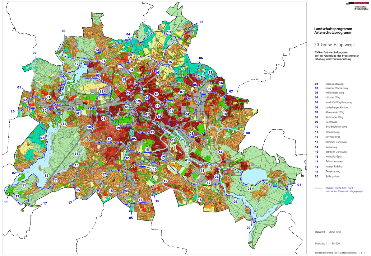
The Hönower Weg , number 07, is one of the 20 main green routes . This is a compilation of 20 hiking trails through the Berlin urban area with a total length of around 550 kilometers. The aim is to link “residential areas with the diverse recreational opportunities in parks and local recreation areas in Berlin and Brandenburg ” (Senate Department for Urban Development and the Environment). The pedestrian should have the opportunity to “experience the city intensely as a combination of culture, history and ecology”. The green Hauptweg 07 is located between the eastern city center and the north-eastern city limits opposite Hönow ; it leads through parks and green spaces and the large housing estates in Hohenschönhausen , Marzahn and Hellersdorf .
course
The Hönower Weg is 21 kilometers long between the Märchenbrunnen in Volkspark Friedrichshain and the city limits at the Hönow underground station . The path leads from the inner district of Prenzlauer Berg - touching Lichtenberg - through Hohenschönhausen, Marzahn and Hellersdorf.
The route coordinates are accessible as "gpx" in a list from the Senate Administration. A digital hiking map using the "Map Berlin 1: 5000" can be reached at FIS-Broker. The course described here is directed from the city center to the outskirts, from Volkspark Friedrichshain to Hönow (in Brandenburg ), the directions and changes of direction were chosen accordingly.
Friedrichshain

The Hönower Weg has its starting point in the city center at the west end of the Volkspark Friedrichshain in Friedrichshain . There is a connection to the Tiergartenring (Hauptweg 19). From the park entrance, both main paths initially lead together around the fairytale fountain . While Hauptweg 19 leads east, Hönower Weg leads north on park paths and remains parallel to Am Friedrichshain street . The Hönower Weg leaves the Volkspark at the north corner. To the right in the park on the slope of the Kleiner Bunkerberg stands the “Monument to the Joint Struggle of Polish Soldiers and German Anti-Fascists”. At the end of the park you will reach the Prenzlauer Berg district by entering Virchowstraße . The amusement park in the Neuer Hain , which follows on the right, still belongs to Friedrichshain.
Prenzlauer Berg and Fennpfuhl


After leaving the Volkspark, the Hönower Weg leads across the district border from Friedrichshain-Kreuzberg to Pankow into Kniprodestrasse and 180 meters along its meadow and sports area (City Beach) to the left, crossing the street through Pasteurstrasse to Arnswalder Platz . On the park paths of Arnswalder Platz the traffic light-controlled Danziger Straße (2nd ring road) is crossed, on Bötzowstraße with trees ( Bernhard-Lichtenberg- , John-Schehr- , Martha-Walter- , Rudolf-Schwarz- , Anton-Saefkow-Straße ) The Saefkowpark is then reached, where it touches a section of the main path 18 . To overcome the S-Bahn route , the path leads east within the park to the Kniprodestrasse bridge . North of the railway site on the left sidewalk of Kniprodestrasse via Storkower Strasse (traffic lights) to Hanns-Eisler-Strasse . Behind the residential buildings of the Einstein street at the small green strip consists of Einstein Park . On Hanns-Eisler-Straße at the pedestrian traffic lights (3rd city ring), Hönower Weg leads into Altenescher Weg to the Prenzlauer Berg public park . Prenzlauer Berg ( 90 m above sea level ) can be walked a little to the left on the low park path. The park paths are on the former access road for this mountain of rubble . This means that steeper paths to the viewing platform or without an incline on or through the allotment gardens (KGA 'Neues Heim', 'Grönland', 'Am Volkspark Prenzlauer Berg') are possible. At the exit of the park, the street on the Lichtenberg district border in front of the tennis courts at the garden restaurant “Zur Laube” must be taken to the left. The Hönower Weg goes north through the KGA 'Langes Höhe' on road 106 to Weißenseer Weg .
Old Hohenschönhausen

On road 106, at the level of the commercial property (bus parking space) after the allotment gardens, there is the change of district from Prenzlauer Berg to Lichtenberg , from the Pankow district to the Lichtenberg district . The road 106 is a remnant of the Oderbruchstraße and is an unpaved path between and the Jewish cemetery , on the eastern edge of which a strip of allotments stretches along the cemetery wall, and the industrial wall. Then you reach the busy Indira-Gandhi-Straße . About 40 meters to the right, the street turns into Weißenseer Weg and crosses to Fritz-Lesch-Straße , which takes the green Hauptweg 07 between the Sportforum and the brewery , next to the Olympic base and the sports school on one side and the Hohenschönhausen cemetery (St .-Markus-Gemeinde) on the other hand leads to the Orankeweg . The Orankeweg to the right at the residential branch of the Hansastraße and its houses it goes to the Pankow district border, outside of the district Weißensee at the houses of the Orankestraße to the left to the Orankesee . Cross the Oberseestrasse at the level of Waldowstrasse through the Orankeseepark and south of the 'Freibad am Orankesee' area and past the inn on the Orankesee . The Hönower Weg runs on the south bank of the Obersee and on its east bank through the Kätheplatz to Käthestrasse and to the right in the curve to Oberseestrasse and again right to Degnerstrasse .

Via Degnerstraße to Konrad-Wolf-Straße , it is a little offset into Bahnhofstraße to Große-Leege-Straße which is opposite an industrial area to Gärtnerstraße, which was once built with the Tegel – Friedrichsfelde industrial railway at the former Hohenschönhausen freight station. Their abandoned railway line is intended for the main route, but not (yet) (continuously) accessible to the Papenpfuhl basin .
At the end of the cul-de-sac, you leave Bahnhofstrasse and turn right into Genslerstrasse , with the Berlin-Hohenschönhausen Memorial on the left. At the surrounding wall, the main path then leads left into Lichtenauer Straße , at the end of which turn right into Arendsweg around the residential estate , past Lössauer Straße into Schleizer Straße to the left. Ferdinand-Schultze-Strasse is crossed to the neighboring Plauener Strasse between the five-storey residential buildings and the fallow land with the following vehicle registration office, while Hönower Weg leads through the settlement to Rhinstrasse. This is crossed at the traffic lights and at the intersection of Plauener Straße and Straße 158 / Treffurter Straße , turn right into the unpaved Treffurter Straße ( Worbiser Straße ), the second left ( Witzenhauser Straße ) to the left through the KGA 'Sonnenblume'. At the crossing Dingelstädter Straße , which is taken to the right, the connection to the ideal tour would be reached. From the right the Allendorfer and from the left the Themarer Straße, the district is left at the Landsberger Allee .
Marzahn

On Landsberger Allee, the Marzahn section has been reached and the change of location is complete. At the same time, the district border between Lichtenberg and Marzahn-Hellersdorf lies on the northern edge of the avenue . First of all, the tram line to Marzahn has to be crossed here, then the sidewalk on the opposite side of the street to the left (eastward) is recommended: At the traffic lights, cross the busy Landsberger Allee to the Pyramidenring . This is where Hauptweg 7 meets 6, Lindenberger Korridor . Both paths together lead past commercially used nine-story office buildings on the southern sidewalk of Landsberger Allee. The bridge over the Berlin outer ring is used, but the subsequent Marzahner bridge over Wriezener Bahn and Märkische Allee is left out. Between the two bridges on Landsberger Allee there is a staircase (traffic sign 355 pedestrian underpass or overpass ) that leads down to Frank-Schweitzer-Strasse and both main paths lead to the passage through Landsberger Allee. From here, a green corridor between the railway line and the Knorr industrial park heads north to the Grenzgraben . After the passage, you can turn right to reach the Marzahn S-Bahn station . At the Grenzgraben against the direction of flow, next to a district heating pipeline, adjacent to the high-voltage line through the Bürknersfelde industrial estate with the (empty) Wiesenburger Weg retention basin, both main routes lead to the east-south bend in the Grenzgraben. The planned continuation of the Lindenberg corridor on the district heating line to the north along the railway line is not continuously accessible, so that both paths are still together on the Marzahn-Hohenschönhauser Grenzgraben up to the Bürknersfeld road bridge. only here does main path 6 lead north. The Hönower Weg (No. 7) crosses the Boxberger Straße and leads through the green and bush area diagonally to the Unkenpfuhl, which is surrounded by a nature reserve in the northwest of the Marzahn Park Cemetery . It continues on the southern edge of office buildings in Bitterfelder Straße and from there using the straight part of Otto-Rosenberg-Straße to Otto-Rosenberg-Platz, the western station forecourt at the Raoul-Wallenberg-Straße S-Bahn station .

The main path leads through the station underpass with access to the central platform under the Wriezener Bahn (S-Bahn to Ahrensfelde) and Märkischer Allee into Raoul-Wallenberg-Straße . After the first residential complex to the north, the height of the second exit from Stolzenhagener Strasse is crossed to Ludwig-Renn-Strasse . On this north and at the end diagonally to the left around the retention basin to Marzahn Wedding Park and further on a road in the street of Alfred-Döblin-Strasse below the Rabindranath-Tagore-Gymnasium at the garden of the meeting to the east and through the Marzahn Bürgerpark . In the Bürgerpark around the children's pool, Lea-Grundig-Strasse is reached at the Karl-Friedrich-Friesen-Grundschule , before the tram lines M8 and 16 cross on their own route. Furthermore, the Rudolf-Leonhard-Straße used. The left byways of the road through green areas are recommended. At the left Karl-Holtz-Straße and the right Schönagelstraße the path leads to Blumberger Damm , over this diagonally right to the Weidenpfuhl at the following rain retention basin the route leads straight south of the Hohensaatener Straße on the park path to the houses and the parking lot at the Brodowiner Ring . On Ringenwalder Strasse, Landsberger Allee is crossed next to the BVG depot Marzahn to the Wiesenpark . The Wiesenpark belongs to the Wuhle lowlands and between Wuhle (to the west) and Neuer Wuhle is the border between the districts of Marzahn and Hellersdorf ; the Wuhleweg runs across the rivers . The main path remains on the park path, a shortened bridge in the extension of the parking area is probably planned, as it is still not accessible. The Hönower Weg reaches Eisenacher Strasse on the southern edge of the park . Opposite is the entrance to the Gardens of the World . The Hönower Weg uses the Eisenacher Straße to the left to the Hellersdorfer Bridge . When crossing the first river, the Wuhle, Marzahn is left.
Hellersdorf
On the Hellersdorfer Brücke in the course of Eisenacher Straße , the district of Hellersdorf is reached between Wuhle and Neuer Wuhle , at the same time Hauptweg 7 meets Hauptweg 14, the Wuhletal hiking trail that runs along the east bank of the Neuen Wuhle. Both main routes run together to the north (to the left) until Hönower Weg turns into Kyritzer Strasse after the six-storey apartment block facing east, with the pipes of the district heating line being bridged. This street on the bypass straight ahead, inter alia at the Sartre-Gymnasium and over the Alte Hellersdorfer Straße , the main path continues - on the left a green wasteland to Zossener Straße . It follows the Havelländer Ring and over the Kastanienallee then on its side street straight ahead north (left of) the Pusteblume-Grundschule and over the two-lane Stendaler Straße with tram and pedestrian crossing . Past apartment blocks with a green environment, the Hellersdorfer Promenade leading to the south is crossed and the main path crosses Tangermünder Straße into Zerbster Straße .
.JPG)
At the eastern end of Zerbster Straße, the Hönower Weiherkette , a nature reserve, is reached south of the Beerenpfuhl. The park trilogy green corridor leads to the south , parallel to Zerbster Strasse / Naumburger Ring, east and west of Oschatzer Strasse / Weißenfelser Ring, each over Quedlinburger Strasse. The LSG 'Hönower Weiherkette' is bounded on the northern edge by the city limits of Hönow (municipality of Hoppegarten ), with the Landsberger Chaussee in Eiche (municipality of Ahrensfelde) and Berliner Straße in Hönow (municipality of Hoppegarten) running outside of Berlin on Brandenburg territory. The Hönower Weg touches in the pond chain after the Beerenpfuhl, Weihenpfuhl, on the other side of the Louis-Lewin-Straße Obersee, Rundes Soll, Mummelsoll, Froschpfuhl and Untersee to the north, the Krautpfuhl to the west (behind the Bogensee), and also on the west side of the Weidenpfuhl and around the duck pond. Beyond the city limits, east of Mahlsdorfer Straße in Hönow, there are still the pike and perch lakes.
The Hönower Weg ends on Böhlener Straße in front of the Brandenburg border with Hönow at the Hönow underground station , where there is a connection to Berlin's rapid transit network with underground line 5 .
Local transport connections
Nearby ports located on public transport are from the city of Metro Station Strausbergerplatz , S-Bahn station Greifswalder Straße S-Bahn station Raoul Wallenberg Street, underground station Hönow .
literature
- Hiking map Berlin City. Strolling - walking - hiking . 1st edition. piekart, Berlin 2012, ISBN 978-3-935863-22-3 .
- District office Marzahn-Hellersdorf: hiking routes in Marzahn, Wuhle-Hönow-Weg . (PDF) ( Memento from July 29, 2014 in the Internet Archive )
Web links
- 20 Green Main Paths , website of the Berlin Senate Department for Urban Development and the Environment, accessed on January 5, 2014.
- Overview map of the 20 hiking trails , website of the Berlin Hiking Association, accessed on January 5, 2014.
Individual evidence
- ↑ Path number: 7
- ↑ FUSS e. V.
- ↑ The BUND project "20 Green Main Paths"
- ↑ Project "20 Green Main Paths® in Berlin"
- ^ Association for hiking in the LSB Berlin
- ↑ Senate Department for Urban Development and the Environment , Unit IE Nature Conservation, Landscape Planning and Forestry
- ↑ Chronicle of the 20 green main routes on berlin.de
- ↑ 20 main green paths. In: Website of the Berlin Senate Department for Urban Development and the Environment. Retrieved January 31, 2017 .
- ↑ The BUND project “20 main green paths”. In: BUND website . Retrieved January 31, 2017 .
- ↑ Path number: 7
- ↑ stadtentwicklung.berlin.de: XML file without style information - tree view of the document
- ↑ FIS-Broker map display 20 green main routes - digital hiking map
- ↑ Memorial sites portal on places of remembrance in Europe
- ↑ compare RBD 1946: Management of the industrial railway in Hohenschönhausen and the location of the city map of Berlin 1907
- ^ Information from the Marzahn-Hellersdorf district office on the Hönower Weiherkette; accessed on January 3, 2011 ( Memento from July 30, 2014 in the Internet Archive )

01 Spreeweg | 02 Spandauer Weg | 03 Heiligenseer Weg | 04 Lübarser Weg | 05 North-South Path | 06 Lindenberg Corridor | 07 Hönower Weg | 08 Kaulsdorfer Weg | 09 Dahmeweg | 10 Britz-Buckower Weg | 11 Wannseeweg | 12 Havelseenweg | 13 Barnimer Dörferweg | 14 Wuhletal hiking trail | 15 Teltower Dörferweg | 16 Humboldt track | 17 Teltow Canal Path | 18 Inner parking ring | 19 Tiergartenring | 20 Bullengrabenweg