
Volkspark Prenzlauer Berg
| Volkspark Prenzlauer Berg | ||
|---|---|---|
 "Hohes Plateau" in the Volkspark |
||
| height | 90.9 m above sea level NHN | |
| location | Pankow , Berlin ( Germany ) | |
| Coordinates | 52 ° 32 '12 " N , 13 ° 27' 44" E | |
|
||
| Type | Mountain of rubble | |

The Volkspark Prenzlauer Berg - originated from the former Oderbruchkippe - is an approximately 29 hectare park on the eastern edge of the Pankow district, Prenzlauer Berg district . The main part of the park is a rubble mountain double summit, which at its highest point (called: "Poplar plateau") is 90.9 m above sea level. NHN is high. The other peak, more towards the Hohenschönhauser Strasse, is called "Hohes Plateau" and a stone marker says it is "the highest point in Prenzlauer Berg", but this is imprecise. Because according to measurements in the 1990s, it is only 89 m high. The summit twins are among the higher elevations in Berlin .
History of origin
_Volkspark_Prenzlauer_Berg.jpg)
Until the end of the 19th century, there were arable land and fallow land on the site of today's park, as well as a waste disposal site for the Berlin market halls. Around 1920 a small villa colony and an allotment garden were created.
After the Second World War , further storage options were sought for the rubble of the destroyed and cleared buildings in the area around Alexanderplatz, as the bunker overflows in Friedrichshain , Gesundbrunnen and on Teufelsberg were filled. The magistrate decided that a rubble dump should be created on the areas previously used with allotment gardens between Oderbruchstrasse and Schneeglöckchenstrasse . For administrative purposes, this was then named after the street on which it was to be built: Oderbruchkippe . From 1963, after the allotment gardens had been cleared, trucks and the rubble tram brought around 15 million cubic meters of rubble to this area. Distributed over two storage areas, a double mountain was created almost 40 m above the level of the adjacent areas. Building on the area was not considered, as subsidence was to be expected. After the Wall was built, from 1961 the houses in the wall strip, for example from Bernauer Straße , were poured here. Most of today's park paths were created on the routes of the delivering trucks . At the end of 1982 the last plot of land in the allotment gardens was rededicated. In the 21st century there are still allotment gardens on the northern edge up to the Jewish cemetery (KGA 'Volkspark Prenzlauer Berg', KGA 'Grönland', KGA 'Neues Heim'). A strip about 50 meters wide along Hohenschönhauser Strasse , on which the tram route was to the right of the roadway, initially belonged to the Lichtenberg district. With the district reform 2001 he was assigned to the Pankow district. Since then, the Volkspark has bordered the Fennpfuhl district in Lichtenberg in the southeast along this street and street 106 (access to the tennis courts).

In the middle of 1967 the greening of the area began with different tree species from the European area. Above all, pioneer trees should grow quickly and well, be undemanding and hardy. The trees in the 21st century are poplar , ash , maple , locust and willow . About 60 percent of the park consists of trees and bushes, the rest are paths and meadows with a large variety of wild plants. After the planting and the creation of the paths including the nature trail (1971), the Oderbruchkippe was renamed Volkspark Prenzlauer Berg in 1969 and thus entered into the city maps.
location
The streets of Süderbrokweg, Sigridstraße, Schneeglöckchenstraße, Maiglöckchenstraße, Oderbruchstraße / Hohenschönhauser Straße border the park, directly to the north is the allotment garden 'Am Prenzlauer Berg e. V. ' on.
To the south of the park area is the Lichtenberg district of Fennpfuhl , equipped with new buildings from the 1970s. In the west, the park borders on the new development area on Michelangelostraße .
use


Through the planting and the construction of a children's playground halfway up (1997 as an adventure playground), the park is mainly used for recreation and leisure. During the warm months is jogged , fulled or went for a walk in the fall, visitors can fly kites and in winter when snow from the flat unplanted slopes tobogganing .
New and replacement plantings ensure the biodiversity of woody plants; Conifers have now also been added. Finally, the function as a green lung for the residential area and as a biotope for numerous species of birds (57 species were observed at the beginning of the 21st century) and small wild animals should be emphasized. This parking area is a green corridor for the climatic connection between the city center and the north-eastern peripheral areas.

The area, which becomes flatter towards Hohenschönhauser Strasse, was redesigned in the second half of the 1980s. Honor roll calls were held on state holidays at the monument erected in 1987 by the sculptor Gerhard Rommel for the fighting groups of the working class . The memorial was dismantled after German reunification . The entrance gate of the Volkspark was probably erected from the sandstone remains of the staircase . The gardening authorities Wolfgang Zipperling (1957–1970), Reinhild Zagrodnik (1970–1986) and Wolfgang Krause (1986–2001) were involved in the redesign of the park until 1999.
Art in the park

With the facility as a recreation park, orders were placed with sculptors. The commissioned works can be seen as cultural trails in various places, especially at the entrances to the park. The inscription on the frieze "History of Prenzlauer Berg" : "A mountain was heaped up here from the ruins of the Second World War and the park was created."
- Father and Son - bronze statue by Stephan Horota , 1970/71, stolen in the 21st century
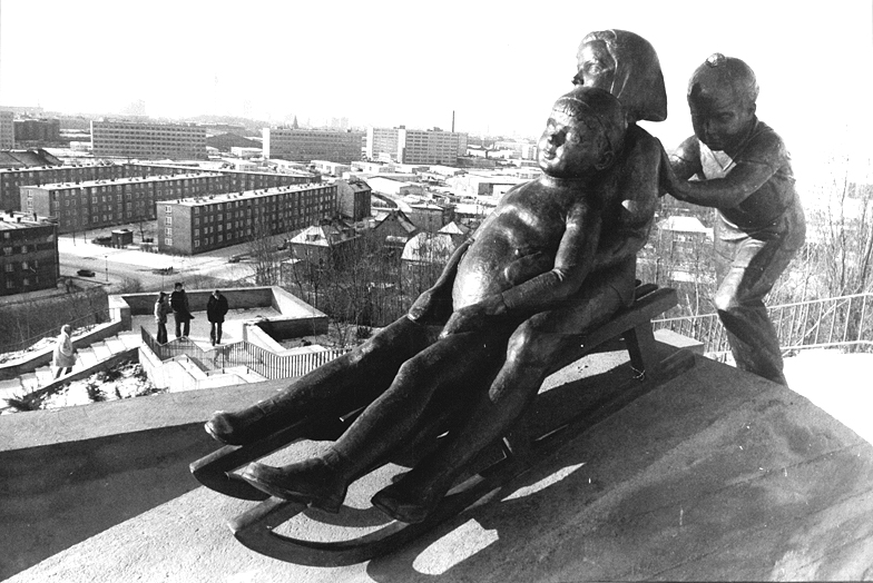
- Tobogganing children - bronze figures by Erwin Damerow , 1972
- Young fox - bronze figure by Stephan Horota , 1972, is on 19./20. September 2012 was stolen by previously unknown perpetrators
- Bear - artificial stone by Erwin Damerow , 1973,
- Seated boy - bronze figure by Werner Stötzer , created in 1956, moved here after 1991,
- From the history of the park's origins - bronze panels as an approximately ten meter long frieze by Birgit Horota , 1971–1973; at the park entrance at the corner of Maiglöckchenstrasse, almost unrecognizable by spraying over it.


Web links
- Green places in Prenzlauer Berg. Volkspark Prenzlauer Berg. In: berlin.de. District Office Pankow of Berlin, archived from the original on September 29, 2007 ; accessed on December 13, 2016 .
Individual evidence
- ↑ a b Digital topographic map 1: 10,000 (DTK10) , on stadt-berlin.de
- ↑ Text on the memorial plaque: “The park you are now entering covers an area of almost 29 hectares. At the turn of the century, agricultural areas, meadows and a garbage dump in the Berlin market halls dominated the scene. With the industrial boom in Berlin after 1871, the city began to expand into its green belt. Allotment gardens and single-family houses were built between Kniprodestrasse and Oderbruchstrasse. During the Second World War, people from the city center fled here from the bombs. When construction began after 1945, rubble from the area around Alexanderplatz was brought to this place. The Oderbruchkippe was created and took up around 15 million cubic meters of overburden. The now mountainous area filled the volunteers with topsoil on sown lawn and planted pioneer trees. In 1969, the newly created natural landscape could be inaugurated as the Volkspark Prenzlauer Berg. In the course of time, today's forest-like biotope with 60% wooded area and 40% meadows emerged. The botanical nature trail has existed since 1971, the wetland biotope and the adventure playground since 1997. The bird world has 57 species. Wild animals up to foxes find their habitat here. The gardening authority Dr. W. Zipperling, R. Zagrodnik and W. Krause. "
- ↑ Angela M. Arnold, Gabriele von Griesheim: rubble, railways and districts . Self-published, Berlin 2002. ISBN 3-00-009839-9 ; Pp. 168-180.
- ↑ Rolf Gänsrich: Unknown corners in Berlin - Oderbruch dump . In: Prenzlberg Views , July 2014.
- ↑ a b Information boards at the Schneeglöckchenstraße park entrance; As of 2008.
- ^ Died sculptor Gerhard Rommel . In: Berliner Zeitung . June 11, 2014, p. 23 .
- ↑ List of the gardening department heads of the permanent conference of gardening department heads at the German Association of Cities since it was founded in 1958 or since 1945. (PDF; 40.1 kB) In: galk.de. April 28, 2008, p. 2 , archived from the original on June 13, 2016 ; accessed on December 13, 2016 .
- ^ Art theft in the Volkspark In: Pankower Allgemeine Zeitung, July 5, 2012; accessed on June 27, 2017.
- ↑ View of the sculpture Tobogganing Children on ringbahn.com, accessed on January 8, 2016.
- ^ Theft of a bronze sculpture from the Volkspark Prenzlauer Berg in Berlin ( memento from October 4, 2012 in the Internet Archive ), accessed on June 27, 2017.