
Spreeweg (Berlin)
| Spreeweg / Berlin glacial valley | |
|---|---|
 Green main path No. 01 in the Spreebogenpark |
|
| Data | |
| length | 60 kilometers |
| location | Berlin (green main path) |
| Supervised by |
FOOT e. V. BUND-Berlin Citizens' Project "Network" Berliner Wanderverband Stadtentwicklung |
| Markers |
 Blue field, white "1" |
| Starting point | L 38: Fürstenwalder Damm Berliner Strasse in Erkner 52 ° 25 ′ 41 ″ N , 13 ° 44 ′ 29.7 ″ E |
| Target point |
Regional train station Albrechtshof 52 ° 32 ′ 59.2 ″ N , 13 ° 7 ′ 41.4 ″ E |
| Type | trail |
| Height difference | low |
| Level of difficulty | inner city and park path |
| particularities | 1 of the 20 hiking trails through Berlin's green urban area and parks |
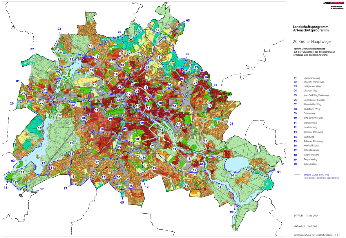
The Spreeweg / Berliner Urstromtal is number 01 one of the 20 main green routes . This is a compilation of 20 hiking trails through the Berlin urban area with a total length of around 550 kilometers. The aim is to link “residential areas with the diverse recreational opportunities in parks and local recreation areas in Berlin and Brandenburg ” (Senate Department for Urban Development and the Environment). The pedestrian should have the opportunity to “experience the city intensely as a combination of culture, history and ecology”.
course
The Spreeweg / Berliner Urstromtal is the longest green main path at 60 kilometers. The addition to the name " Berliner Urstromtal " describes the course of the Spreeweg in the Warsaw-Berlin Urstromtal , which was formed during the last Ice Age . There are therefore hardly any heights to be overcome. It accompanies the Spree through the city between Hessenwinkel in the east and the Falkenhagener Feld in the west . The path leads through quiet forests on the outskirts, large industrial areas with adjoining allotment gardens, the medieval city centers of Köpenick and Spandau and the modern city and mostly near the shore. Careful planning of the government district left space to lead it through the center. The Spree flows into the Havel in Spandau , but the hiking trail continues here in the lowlands of the Spektegrünzug to the state border to Brandenburg in the west.
The location of the paths can change for a short time due to urban development.
Hauptweg 01 cannot always follow the bank of the Spree. The tour in Niederschöneweide is only partially accessible and the ideal route through Oberschöneweide and Wuhlheide is bypassed. Old commercial areas on the banks of the Spree partly prevent space from being kept free for a riverside path. When the government district was set up, the riverside path remained open to the public, contrary to original security concerns. In the following sections, large areas are commercially used (and thus inaccessible) riparian strips. Such limitations have been removed west of the Havel during the guided tour in the Spandauer Spektewiesen. This western part also justifies the addition " Berlin Urstromtal " for the "Spree" away.
Rahnsdorf

In the east of the Spreeauf, Hauptweg 01 begins at the city limits to Erkner . From the state border of Brandenburg in the locality of Hessenwinkel from Rahnsdorf the European cycle route R1 comes to Berlin. From Berliner Strasse in Erkner on Fürstenwalder Allee in Berlin, it joins the Spreeweg. It is located a little north of the Dämeritzsee through which the Spree flows. This starting point can be reached from the Erkner S-Bahn station, 750 meters away . After 450 meters from the entrance sign, turn left into Lutherstrasse and then right into Ahornstrasse , followed by the transition into Lindenstrasse . The direct access to the shores of Dämeritzsees because of the surrounding land only at the Dämeritzstraße possible and continue only as a view between the houses. Again to the left on the Kanalstrasse and past the Kurzen Strasse and the opposite Hubertussee , the hiking trail continues to the right into the Haselwinkel and left into the Triglawstrasse . It leads to the Triglawbrücke over the Müggelspree to the island in the south of Hessenwinkel. On a path to the right of Triglawstraße, the "Russenbrücke" (a pedestrian bridge) goes over the old Spreearm, where you leave the district.

Müggelheim
Via the 'Old Spreearm', the district of Müggelheim north of 'Philipps Fischerhütten' is reached from the shared location Radfernweg R1 / Hauptweg 01 and leads into the Berlin urban forest Köpenick, which is here designated as a nature reserve, as well as through the northern part of the European bird sanctuary Müggelspree . 960 meters through the forest area on the southern edge of the Schönhorst settlement is reached. To the left of Lindenstrasse , which is dedicated as a residential street , the path leads west on Schönhorster Strasse . Forest areas it is between the nature reserve of the forest and the conservation area Müggelheimer meadows round. The street corner to the ferry / to the Müggelheimer Wiesen , the next destination is marked with the blue 01. The road leads to the F24 ferry (Berlin's last rowing ferry until the 2010s), which crosses the Spree to Rahnsdorf . The hiking trail goes straight ahead and touches the “Neu-Helgoland” restaurant to the south of the Bauersee at its outlet. The departure point of the F23 ferry and restaurant seats are located directly on the Müggelspree . The wide driveway from the restaurant leads to the confluence of the Müggelspree in the Kleiner Müggelsee and on its banks. The district is left 200 meters before the road to Müggelhort .
Koepenick


On the shores of the Kleiner Müggelsee there is the change of district from Müggelheim to Köpenick , whereby the lake itself belongs to Rahnsdorf. The Müggelhort settlement at the outflow of the Spree from the Kleiner to the Großer Müggelsee was built around the traditional forest restaurant and remains untouched to the right of the Spreeweg. The Müggelseepromenade leads along the main path on the south bank of the Müggelsee through which the Spree flows. As a riverside path, it goes past the former "Müggelseeperle" (today: "Hotel Müggelsee") and the excursion restaurant "Rübezahl" with the Teufelssee district forester and the LSG 'Kuhwall'; the path then follows the bank northwards. At the outlet of the Müggelspree from the Großer Müggelsee, the European hiking trail E11 comes to Hauptweg 01. It leads from the Friedrichshagener side through the Spreetunnel , which connects Köpenick and Friedrichshagen at 80 meters under the Spree . The Spreeweg lives up to its name and goes together with the long-distance hiking trail on the banks of the Müggelspree and next to the Kämmereiheide to the Salvador-Allende Bridge . In front of the bridge, to the left of the path, there is already built-up area around the Amtsteich and the Amtgraben, including the district regulatory office.
After the bridge, the riverside path is no longer accessible. The main path leads under the bridge to the left onto the bypass of Salvador-Allende-Straße and further to the right into Wendenschloßstraße . These two streets take over the traffic of the southern bypass of the old town of Köpenick and despite the byways the traffic is close. The banks of the Spree can be reached at the 'Little Venice' settlement. The main path leads on Wendenschloßstraße over the branch canal ( Wendenschloßbrücke ) and on its banks to the Spree. Since the bridge over the Kietzgraben is missing, it goes on the Amtsstraße to Landjägerstraße . Here the long-distance hiking trail E11 continues straight ahead, the Spreeweg to the right to the Landjägerbrücke . About the Old Market (right local history museum) and at the Spindler street left into Katzengraben next to the Futranplatz to the houses at the fire station. Here the Spree is reached, where the Katzgrabensteg leads to the right to the Baumwerder island and the Krusenick peninsula. To the left, the main path at Köpenicker Freiheit leads close to the bank to the dam bridge and under it.
From the Köpenick dam bridge to the south lies the east bank of the Dahme on which the riverside path runs parallel to Alt-Köpenick through the Luisenhain and also the long-distance hiking trail E11. To the left of the bank and across the street is the historic Köpenick Town Hall . You go around the Dahme via the footpath of the Long Bridge . On the west side of the Long Bridge, the Dahmeweg begins at Köllnischer Platz southwards. The Spreeweg to the right on Gutenbergstrasse and separated from the Dahmewestufer to the Spree-Eck ( maps ). With the confluence of the 190-meter-wide Dahme into the 100-meter-wide Müggelspree, the Spree now regains its name without the addition of “Müggel-”. The riverside path, initially obstructed by the residential building at Flemmingstrasse 18/19, reaches the banks of the Spree and through Mentzelpark and next to the former Spindler laundry, leads onto Eiselenweg separated from the bank by the properties. At the following Wilhelm-Spindler-Brücke , the ideal tour in Niederschöneweide on the banks of the Spree is not continuously accessible. The Spreeweg leads over the bridge and leaves the district with the bridge ramp to the Beiweg, as the district boundary is on the south bank of the Spree.
Oberschöneweide

On the Wilhelm-Spindler-Brücke, which has been expanded for the planned east tangential, the Oberschöneweide district is reached with the bypass on the right-hand side . The Spree is crossed on Spindlersfelder Straße to the north bank. At the traffic light intersection with the street on the Wuhlheide , turn left through the railway bridge of the Berliner Ring and then right into the street to the FEZ in the Volkspark Wuhlheide , first (at the parking lot) at the level of the Eichgestell station the park railway on the Eichgestell at the FEZ and Pass the Parkbühne Wuhlheide and continue through the Volkspark Wuhlheide. This is followed - always accompanied by hiking trail E11 - the second crossing of the park railway, on the left the municipal cemetery , on the right the model park (3D miniature map of the two states of Berlin and Brandenburg) which is separated by a wet meadow from the trotting track in Karlshorst and at the height of the summer pool Wuhlheide, the path bends to the left to the intersection of Treskowstrasse / Edisonstrasse with An der Wuhlheide / Rummelsburger Strasse , the latter also being an elevated road. The crossing will be changed north / west to Rummelsburger Strasse. On the left byway to Mentelinstraße left ( Fust- , Watt- , Otto-Krüger-Straße ) and right at Nalepastraße . The path to Nalepastraße leads around the allotment gardens (KGA) 'Grüne Aue', on the Grenzweg the route is kept free for road planning across the Spree to Niederschöneweide, and the main path lies between KGA 'Oberspree' and 'Am Freibad'. After the right- Fritz King Street , turn left on the Spree Castle Street to ferry F11 over the Spree. On the opposite bank of the Spree, the Spreeweg leaves the district with the E11 European hiking trail.
Plänterwald

The Plänterwald district is reached at the F11 jetty on the south bank . Here in the park that gave the district its name, the current tour of the Spreeweg through Oberschöneweide meets the planned ideal tour on the south bank through Niederschöneweide. The bypass route through Oberschöneweide and the planned main route meet again at the ferry terminal. From this plan run the Teltower Dörferweg begins not far from the Walter-Spindler-Brücke , in places the bank of the Spree is already accessible to the Plänterwald , for example on the (eastern) Schnellerstraße, from Britzer / corner of Hainstraße at the level of Kaisersteg to the industrial park Both sides of the Treskowbrücke (accessible from Brückenstraße), and continuously from the Marggraffbrücke on the east bank of the Britzer connecting canal , the Plänterwald district is reached, on the Niederschöneweider side there is the road construction area that has been kept free for the urban planning east bypass.
From the ferry station, the riverside path leads down the Spree past the “ Eierhäuschen ” (Plänterwald excursion restaurant) and around the currently idle Spreepark (former amusement park) to the end of the Spree on Bulgarische Strasse , parallel to Alt-Treptow the park changes from Plänterwald to Treptower Park . The main route 01 and E11 leave the district here.
Alt-Treptow
.JPG)
The district of Alt-Treptow begins at the Abbey Bridge , which leads to the Insel der Jugend , and with it the Treptower Park (an LSG). The riverside path leads past the traditional Zenner restaurant. The Archenhold Observatory and the Soviet War Memorial can be reached through the park, while the rose garden and the puppet theater can be found a little off the road. The Treptower Park S-Bahn station is at the end of the park . The Spreeweg meets the start of Kaulsdorfer Weg (Hauptweg 08) at the landing stages . The hiking trail E11 remains under the Elsenbrücke on the southern bank of the Spree past the Treptowers . The Spreeweg leaves the district here.
Friedrichshain

Spreeweg and Kaulsdorfer Weg are led over the Parkwegbrücke , to the right of the Ringbahn bridge and the Elsenbrücke across the Spree. The district border of Treptow-Köpenick and Friedrichshain-Kreuzberg lies on the south bank of the Spree, which means that the Friedrichshain district is reached on the bridge . On the left in the Spree you can see the sculpture Molecule Man , which stands near the intersection of the districts Treptow / Kreuzberg / Friedrichshain. The two main routes run alongside the railway line to the Alt-Stralau road . The Kaulsdorfer Weg to the right and the Spreeweg leads to the left through the railway bridge to An den Treptowers coming over the Elsenbrücke. The following busy intersection in the train of the B 96a should be avoided via Alt-Stralau, Markgrafendamm and Stralauer Allee. Continue on the left footpath on Stralauer Allee, as the north bank of the Spree is initially not accessible due to the harbor wall. The building Stralauer Allee 12 (opposite bosses road ) access to the banks of the Spree is possible site of the eastern harbor . The Osthafen buildings here are used by music and designer companies; in front of the MTV building , the Inner Parkring meets the banks of the Spree.

Both paths separate again at the Oberbaumbrücke , main path 18 leads over the bridge to Kreuzberg, main path 01 remains along the north bank of the Spree. The Berlin Wall Trail comes over the Oberbaumbrücke to the north bank and leads to the Mühlenstrasse at the East Side Gallery , which is laid out on the former area of the front wall . The Spreeweg uses the riverside path through the East Side Park , across the street the Mercedes-Benz Arena with the parking lots and various commercial buildings across the Spree. The riverside path is interrupted by 200 meters of building site for the “ townhouses ” and in the following park on the Spree between the bank and the wall on Mühlenstrasse , the bank is accessible. Because of the building (Energy Forum Spree foyer) on Stralauer Platz in front of the Schilling Bridge is again dodged to the left side of the road and on the road at the Schilling Bridge of Spreeweg turn left at the Schilling Bridge over the River Spree. The district boundary of Friedrichshain is on the south bank of the Spree, so the district is left after the bridge.
center

After crossing the Spree on the left side of the Schilling Bridge, Engeldamm is the district of Mitte . The Wall Trail continues straight ahead into Kreuzberg . The Spreeweg leads through the green space at the end of the bridge and under it to Paula-Thiede-Ufer and the following building complex to the left into Bona-Peiser-Weg and then to the right into Köpenicker Straße , as the south bank is no longer accessible. Hauptweg 19 ( Tiergartenring ) crosses at Michaelkirchstrasse . In order to avoid the heavy traffic on Brückenstraße , the route runs over Ohm- , Runge- , Brückenstraße to Jannowitzbrücke . Immediately adjacent is the here S-Bahn station Jannowitzbrücke . In front of the railway bridge of the Stadtbahn , the embankment of which follows the old city fortifications, the main path continues on the Rolandufer on the north bank of the Spree . The riverside path is accompanied on the right by buildings belonging to the Senate Administration and the Berliner Wasserbetriebe ; Littenstrasse , Klosterstrasse and Neue Jüdenstrasse flow into it . The Kupfergraben begins on the opposite bank of the Spree ( Märkisches Ufer ) and here, in addition to the Fischerinsel , is the historic port of Berlin .

Then the riverside path leads under the Mühlendamm bridge into the Nikolaiviertel . It is the oldest city of Berlin and was established in 1987 for the 750th anniversary restored and historicizing rebuilt. Behind the bridge is the Ephraim-Palais , opposite the Marstall . Through the Rathausbrücke ( Rathausstrasse ) you will find the Marx-Engels-Forum on the right and opposite on the banks of the Spree the Schloßplatz with the Humboldtforum, which is currently under construction . The Spreeweg continues through the Liebknechtbrücke ( Unter den Linden / Karl-Liebknecht-Straße ) on the bank opposite the Berlin Cathedral and the Lustgarten and the Altes Museum (Spreepalais, Domaquaree , St. Wolfgang-Straße ). The next bridge is the Friedrichsbrücke , which is reserved for pedestrians and over which the Museum Island can be reached. At the northern bridgehead ( Anna-Louisa-Karsch-Strasse / corner of Burgstrasse ), the north bank leads to James-Simon-Park and through the arches of the Ringbahn into Monbijoupark . At its end, the Spreeweg / Berliner Urstromtal with the Northern Monbijou Bridge leads over the Spree past the Bode Museum and the Kupfergraben is crossed over the Monbijou Bridge shortly before it flows into the Spree. This flowed around from the Mühlendammschleuse to the Museum Island in the south.
The Spreeweg now runs on the south bank again. The Spreeweg lies on the streets Am Kupfergraben , on Geschwister-Scholl-Straße the Ebertsbrücke leads to Tucholskystraße and Hauptweg 01 on Am Weidendamm (Catholic Archbishop's Office) to Weidendammer Bridge and on to the Reichstagufer . At the Weidendammer Bridge is the Friedrichstrasse S-Bahn station with the Tränenpalast on the way and on the opposite bank of the Spree the Panke estuary and the Berliner Ensemble . The Spreeweg leads through the tram bridge following the train station to Dorothea-Schlegel-Platz , after Neustädtische Kirchstraße there are federal and Bundestag administration buildings and the ARD capital studio on the corner of Wilhelmstraße . Here at the Marschallbrücke (formerly the east-west border crossing of the Spree), the north-south path and the wall path change to the southern bank of the Spree. Both bypass the Bundestag administration ( Jakob-Kaiser-Haus ) with the Spreeweg on the bank of the Reichstag . It then follows the river Spree between the Reichstag building and Reichspräsidentenpalais the Friedrich-Ebert-Platz , where once the "east-west dividing" Berlin Wall stood. Nord-Süd-Weg and Mauerweg cross this square towards the Brandenburg Gate . The Spreeweg remains on the banks of the Spree, but the east wall of the Reichstag (seat of the German Bundestag [on the western edge of the square]) forms the district boundary and so the Spreeweg leaves the district. The Spree itself still belongs with the north bank to the district of Mitte.
Zoo


After Friedrich-Ebert-Platz on Paul-Löbe-Allee, which is between the Reichstag building and Paul-Löbe-Haus (seat of the Bundestag administration), the district of Mitte on the south bank of the Spree changes to the district of Tiergarten . Between the Paul-Löbe-Haus and the Spree, the Marie-Elisabeth-Lüders-Steg is reached as a pedestrian bridge between the two houses of the Bundestag administration. Here at the level of Otto-von-Bismarck-Allee , the Tiergartenring (Hauptweg 19) leads to the south bank and this is where the inner-city starting point of the Heiligenseer Weg is located . Spreeweg and Tiergartenring are located in the Spreebogen over Konrad-Adenauer-Straße at the Kronprinzenbrücke . The riverside path ( Ludwig-Erhard-shore ) performs the Spreebogenpark at the dock of the Gustav-Heinemann Bridge over. The Berlin-Spandau shipping canal and the main train station with its connections begin on the opposite bank of the Spree . Also leads crossing the Spree hidden in the city tunnel guided B96 and the north-south tracks between Central Station and Potsdamer Platz by the Spreebogenpark. Finally, at the stone Moltkebrücke the Willy-Brandt-Strasse / Alt-Moabit, crossed before the Spreeweg unhindered by the Federal Chancellery , the House of World Cultures ( Congress Hall reached), opposite to the non-public Chancellor Park in the bond of the covenant with the Chancellery bridge. There, the park at Moabiter Werder follows the Chancellor Park . In the Großer Tiergarten , the riverside path joins the byway of John-Foster-Dulles-Allee . The Spree is already in Moabit . The further course of the main routes 01 and 19 leads to the Luther Bridge to Bellevue-shore . The Luther Bridge connects the Spreeweg street (from the Großer Stern to the Spree) in Mitte and Paulstraße in Moabit. The Spreeweg / Berliner Urstromtal crosses its namesake and runs as a public riverside path between the Bellevue Palace Park with the Federal President's seat ( Bellevue Palace ) to the Bellevue S-Bahn station and at the end of the Palace Park, the Uferweg leaves the district.
Hansaviertel

At the railway bridge of the Ringbahn in front of the Gerickesteg , the Spreeweg leads into the next Spreebogen, which is in the Hansaviertel . Next, the Bartningallee is crossed at the Moabiter Bridge , at the town villas on Holsteiner Ufer under the Lessing Bridge ( Lessing- / Stromstraße ), later under the Hansabrücke the Altonaer Straße is crossed. Because of the following commercial operations that extend to the south bank, the Spreeweg uses the Wullenwebersteg to the north bank and the district is left. The Tiergartenring (Hauptweg 19), which is still a bit close to the shore, turns left into Englische Strasse to Charlottenburg.
Moabit
On the north bank, the Spreeweg in Moabit uses the riverside path on the southern edge of the sports field on Wullenweberstrasse and leads along the Viking bank to the Gotzkowsky Bridge , past Tile-Wardenberg-, Agricola- to Levetzkow- / Gotzkowskystrasse. Then Moabit will also be left.
Charlottenburg

Over the Gotzkowskybrücke to the right, the south bank is reached at the next arch of the Spree in Charlottenburg . The riverside path is located in a green strip on the bank, including the KGA 'Pascal'. The ideal tour would have remained on the south bank without changing to Moabit, which means that the change to Charlottenburg takes place beforehand. After the institute site ( Technische Universität Berlin , Fraunhofer-Gesellschaft ) opposite the entrance to the Charlottenburg connecting canal, a missing bridge over the branch canal on the south bank forces you to leave the bank. On a path next to the commercial buildings it goes to Dovestrasse and this to the right of this canal back to the Spree and then to the exit of the Landwehr Canal to Dovestrasse opposite the Salzufer and to the right over the Dovebrücke . Here the European hiking trail along Einsteinstrasse meets the Spreeweg again. Again in a parking strip on the banks of the Spree, the main path continues westward. From the X-road with the X-bridge parallel to Iburger banks , in the amount of Lütigenweg on Siemens web passing it goes under the Caprivi bridge ( Wintersteinstraße ) parallel to the Charlottenburg banks continue to Luisenplatz and the castle bridge . Here, at the Schinkel pavilion, you reach the palace garden of Charlottenburg Palace on the banks of the Spree and the Inner Parkring meets the Spreeweg / Berlin glacial valley. In addition to the carp pond and the Belvedere, the path in the park leads spreenah north. At the northern end of the palace garden, the Inner Parkring changes over the byway to the other bank of the Spree. Spreeweg and E11 lead through the railway bridge between the railway line to Hamburg and the ring railway opposite the old lock Charlottenburg (KGA 'Schleusenland'). The district is left between the Spree and the railway site in front of the Rudolf-Wissell-Brücke , a structure on the A 100 .
West end


The Westend district is reached under the Rudolf Wissell Bridge . On the Spree side of some allotment gardens (KGA 'Schleusenland II', 'Spreewiesen', 'Tiefer Grund') the path goes along the bank, on the opposite bank of the Spree is the (Siemens) Techno-Park. The riverside path goes to the Fürstenbrunner Weg / the corner of Ruhwaldweg and under the Rohrdammbrücke . The bank of the Spree with the entire course of the river belongs to Siemensstadt in the Spandau district . The main path uses the run along the KGA 'Spreegrund Nord' on the railway site (route to Spandau), here the local route also partly belongs to Siemensstadt, further to KGA 'Moabit-Spree' and 'Dahlemer Wiese Süd'. In front of the KGA 'Dahlemer Wiese Nord', the Spreeweg and E11 move away from the bank and both take the path between these allotment gardens. Before Wiesendamm right of the leading on Hamburg railway Wiesendamm bridge the district is left.
The ideal tour would continue on the banks of the Spree, leaving the E11 long-distance hiking trail and is still accessible on the banks of the Spree up to the suburbs and district boundaries. Opposite on the Spree is the Reuter thermal power station , the Uferweg is blocked by a recycling facility and further on to Spandau the extensive industrial area.
Spandau

The Spreeweg is from Wiesendamm to spreeab in the district Spandau (with change from Charlottenburg-Wilmersdorf in the district Spandau ). The hiking trail E11 continues south over the Wiesendamm bridge. The street Freiheit follows the Wiesendamm . On both sides, the section of the route runs through an industrial and commercial area (waste-to-energy plant Ruhleben, Werkring , Klärwerk Ruhleben , Klärwerkstraße ), on the left are the KGA 'Güterbahnhof Ruhleben' and later the KGA 'Freiheit' on the railway site. At the end of the Liberty is the Stresow S-Bahn station and across Stresowstrasse , next to Schürstrasse , Stresowplatz and Obermeierweg there is the Havel crossing on the Charlottenbrücke in Spandau. On the western banks of the Havel access to done Havelseenweg with which it is common to the left. The Spree, which gives the path its name, flows into the Havel ( maps ) and according to the addition of "Berliner Urstromtal", it continues through Spandau over the Spectegreen to the state border.
_Garde_Grenadier_Regiment_Nr_5.jpg)
The planned tour of the Spreeweg remains close to the shore. The Spree is still accessible on Sophienwerderweg after a short detour on Sophienwerder Ufer. In addition, bridges are still missing on the Ruhleben Altarm and over the Spree. The Spreeweg would be on the north bank, south parallel to the street Am Juliusturm and is partly accessible, but not continuously due to commercial areas. The connection to the further guide and Havelseenweg is north of the Spree flows into the Havel, north of the Julius tower bridge near the lock Spandau (again, the walk-in transition is missing) scheduled on Havelufer.
After Havel crossing on the Charlotte bridge , turn left to Stabholz garden . In this the main path 01 leaves the Havel bank south of the Mühlengraben and the main path 12 towards the city center to Spandau's old town . Over the street Stabholzgarten, through Am Wall and over the Carl-Schurz-Straße the wide traffic street Altstädter Ring is crossed by the pedestrian tunnel at the town hall Spandau . On the left is the Spandau long-distance and S-Bahn station , Hauptweg 01 leads through Münsinger Park over Galenstrasse to Georg-Ramin-Park. In addition to the gardening school 'An derkap', Askanier elementary school and youth traffic school through playgrounds to the KGA 'Tsingtau', the spect meadows are reached. The path leads through this to Zeppelinstrasse, over this the district is left.
Falkenhagener Feld


After Hauptweg 1 has crossed Zeppelinstrasse, you reach the Falkenhagener Feld district . The green area of the Spektewiesen continues in the district parallel to the Spekteweg . South of the weekend settlement 'Lüttenorth' and north of the weekend settlement 'An derkap' it goes over the Nethphener Weg, on the right a retention basin, then past the KGA 'Gustavs Ruh' on the extension of the Spekteweg over the Bötzowbahn (the industrial railway line to the Spandau Johannesstift freight station ). To the south of the Großer Spektesee through the park and under the Am Kiesteich bridge, Hauptweg 01 continues through the Spektewiesen at a distance from the southern district boundary to Staaken . The cross path in the park (extension of road 603 ) leads over a pedestrian bridge at the outflow of the Spektelake to its north bank and follows the curvature of the water, past the Spektelake bridge . Through the southern path of the garden colony 'Neu-Sternfeld' westwards at the sports field to the city limits, the Spreeweg / Berliner Urstromtal meets the Spandauer Weg and the Mauerweg . The district is left at the meeting point.
Staaken
When Hauptweg 01 meets at the city limits with Mauer- and Spandauer Weg, the Staaken district in Albrechtshof is reached. Together, these three paths lead in the green corridor that extends beyond the city limits into Brandenburg to the Finkenkruger Weg . Because of the allied exchange of territory (see Staaken airfield / Zeppelin factories ) in 1945, West Staaken was separated from the Berlin city area from 1950 . In 1961 the Wall was built through Staaken, so the Wall Path and Spandauer Path lead south on this road. In the neighboring town of Falkensee , the Königszelter Straße connects, to the west of this on Hamburger Straße is the historical park on the Große Lake with the former subcamp Falkensee. The Spreeweg leads another 200 meters in a green corridor that extends beyond the city limits to the Brandenburg garden city Falkenhöh , to the Luchweg . Straight ahead on this green corridor you can reach the Panzersee, a geocoaching location. From Luchweg turn right into Albrechtshofer Weg and then left into Alfons-Loewe-Straße and you will reach Seegefelder Weg . Turn this to the right and past Hamburger Straße and you will get directly to the Albrechtshof regional train station . This station on the Hamburger Bahn is the end point of Hauptweg 01 and offers the connection to Spandau and the Berlin urban area.
Local transport connections
The Spreeweg passes near the following public transport connections.
- Regional train station Albrechtshof
- S + U-Bahnhof Spandau
- Stresow S-Bahn station
- Ruhleben underground station
- Jungfernheide S + U station
- Hansaplatz underground station
- Bellevue S-Bahn station
- S + U-Bahnhof Hauptbahnhof
- S + U-Bahnhof Friedrichstrasse
- S + U-Bahn station Jannowitzbrücke
- S + U-Bahnhof Warschauer Straße
- Treptower Park S-Bahn station
- Baumschulenweg S-Bahn station
- Schöneweide S-Bahn station
- Oberspree S-Bahn station
- Spindlersfeld S-Bahn station
- Erkner S-Bahn station
literature
- Hiking map Berlin City. Strolling - walking - hiking . 1st edition. piekart, Berlin 2012, ISBN 978-3-935863-22-3 .
Web links
- 20 Green Main Paths , website of the Berlin Senate Department for Urban Development and the Environment, accessed on January 5, 2014.
- Overview map of the 20 hiking trails , website of the Berlin Hiking Association, accessed on January 5, 2014.
- Claudia Lenk: Interesting facts about the 20 main green paths .
- Spreeweg (3) - Ruhleben underground station to Charlottenburg Palace
- Alexander Glintschert: The second stage . From Friedrichshagen (Spreetunnel) to the leisure and recreation center Berlin, first stage from Erkner, third stage through the city to the S-Bahn station on the viaduct of the Berlin light rail
Individual evidence
- ↑ a b path number: 1
- ↑ FUSS e. V.
- ↑ The BUND project "20 Green Main Paths"
- ↑ Project "20 Green Main Paths® in Berlin"
- ^ Association for hiking in the LSB Berlin
- ↑ Senate Department for Urban Development and the Environment , Unit IE Nature Conservation, Landscape Planning and Forestry
- ↑ Chronicle of the 20 green main routes on berlin.de
- ↑ 20 main green paths. In: Website of the Berlin Senate Department for Urban Development and the Environment. Retrieved January 31, 2017 .
- ↑ The BUND project “20 main green paths”. In: BUND website . Retrieved January 31, 2017 .
- ^ History of the district of Rahnsdorf / Hessenwinkel
- ↑ www.stadtentwicklung.berlin.de: 20 green main paths®> change notification

01 Spreeweg | 02 Spandauer Weg | 03 Heiligenseer Weg | 04 Lübarser Weg | 05 North-South Path | 06 Lindenberg Corridor | 07 Hönower Weg | 08 Kaulsdorfer Weg | 09 Dahmeweg | 10 Britz-Buckower Weg | 11 Wannseeweg | 12 Havelseenweg | 13 Barnimer Dörferweg | 14 Wuhletal hiking trail | 15 Teltower Dörferweg | 16 Humboldt track | 17 Teltow Canal Path | 18 Inner parking ring | 19 Tiergartenring | 20 Bullengrabenweg