
Siemens footbridge
Coordinates: 52 ° 31 ′ 13 ″ N , 13 ° 18 ′ 43 ″ E
| Siemens footbridge | ||
|---|---|---|
 |
||
| use | pedestrian | |
| Convicted | Lüdtgeweg | |
| Crossing of | Spree | |
| place | Berlin-Charlottenburg | |
| construction | Arch bridge | |
| overall length | 77 m | |
| width | 3.5 m | |
| Clear height | 5.1 m | |
| start of building | 1899 | |
| completion | 1900 | |
| opening | August 1, 1900 | |
| location | ||
|
||

The Siemenssteg is a pedestrian bridge in Berlin-Charlottenburg . It spans the Spree from Alt-Lietzow to the Charlottenburg power station . It is a 77 meter long and 3.50 meter wide arched bridge made of metal. There are two 10 meter high sandstone pylons at each of the bridgeheads . The owner of the bridge was Elektrizitäts-AG, formerly W. Lahmeyer & Co. in Frankfurt am Main , which also built the power plant as a Charlottenburg electricity plant and operated it on a lease. The Siemenssteg lies between the Iburger Ufer and the street on the Spreebord, shortly after the junction of the Landwehr Canal and the Charlottenburg connecting canal . The parallel X-ray bridge is located about 180 meters up the Spree .
history
The footbridge was built in connection with the construction of the power station between 1899 and 1900 in order to not only be used as a pedestrian bridge but also to lead the electrical lines to Charlottenburg. It was inaugurated on August 1, 1900. In 1902 the footbridge was named after the manufacturer Werner von Siemens , who had his residence not far. The footbridge was not destroyed in the Second World War , as it was of no strategic importance for street fighting. Today it is one of the well-preserved historical pedestrian bridges over the Spree. In 1960 it was extensively renovated.

Monument Siemenssteg
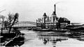
Siemenssteg (center) and thermal power station (right), around 1907


literature
- Eckhard Thiemann, Dieter Deszyk, Horstpeter Metzing: Berlin and its bridges. Jaron Verlag, Berlin 2003, ISBN 3-89773-073-1 , p. 121 f.
Web links
- Siemenssteg monument, pedestrian bridge, 1899–1900; Metal construction renewed after 1960
- District lexicon: Siemenssteg
- Siemenssteg on structurae.de