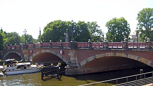
Luther Bridge
Coordinates: 52 ° 31 ′ 4 " N , 13 ° 21 ′ 17" E
| Luther Bridge | ||
|---|---|---|
|
Luther Bridge in the background Victory Column (left) and Bellevue Palace (right) |
||
| use | Road traffic | |
| Convicted | Paulstrasse | |
| Crossing of | Spree | |
| place |
Berlin districts Tiergarten and Moabit |
|
| overall length | 60 m | |
| width | 25.88 m, of which 15 m is roadway | |
| vehicles per day | 340 trucks 17,100 vehicles |
|
| start of building | 1891 | |
| completion | 1892 | |
| planner | Karl Bernhard and Otto Stahn | |
| location | ||
|
|
||
The Luther Bridge is a listed stone car, bicycle and pedestrian bridge over the Spree in Berlin . It is located in the Mitte district and connects the Spreeweg in the Tiergarten district with Paulstrasse in the Moabit district . The bridge, built between 1891 and 1892, is in the immediate vicinity of Bellevue Palace and the park on the Federal President's Triangle . It was named in 1893 after the German reformer Martin Luther .
history
The Luther Bridge was built at the instigation of the City of Berlin, which wanted to create a connection to the buildings of the Royal Provision Office and the Hamburg-Lehrter freight station on Paulstrasse.
The engineer and government master builder Karl Bernhard was responsible for the construction of the three flat circular segment arches with a clear width between 16.30 m and 17.00 m, which cross the Spree at an angle of 71 degrees . The piers and abutments of the bridge each rest on 2 m thick concrete foundations. The river piers are 3.15 m wide at the base and taper to 2.60 m up to the height of the normal water level. Because of the curvature of the course of the Spree at this point, the top of the central arch is higher than usual at 5 m above normal water level.
The representative decoration of the building, which was due to the proximity to Bellevue Palace, was done by the architect Otto Stahn . He had the visible surfaces of the bridge veneered with clinker bricks and erected four large bridge pier heads made of sandstone, which, with their capitals, rise up to the level of the railing, where cast-iron lanterns on a base sit on them. Over each of the bridge arches, five artfully crafted, wrought-iron railings span between spherical sandstone pedestals and the lantern bases. In the area of the abutments at the four bridgeheads, mighty obelisks rise on which golden stars sit.
The bridge is 25.88 m wide between the railings, with 15 m falling on the roadway and the rest on the sidewalks and bike paths on both sides. Supply lines with electricity, gas and water run under the granite pavements. The original road surface was made of wooden paving; today the bridge is paved.
In 1937 the corroded gas lanterns were replaced by new three-armed cast iron candelabra and the heavily damaged pedestal balls were removed. During the Second World War , the Luther Bridge suffered severe damage when the German Wehrmacht was blown up . The southern arch of the bridge sank into the Spree, the lanterns were lost. Immediately after the end of the war, the bridge was provisionally repaired and rebuilt in a simplified form in 1950/1951. The lost arch was replaced by a reinforced concrete structure with sandstone and clinker facing.
A comprehensive renovation of the Luther Bridge took place between 1974 and 1979, with the roadway and sidewalks also being renewed. To seal the bridge, the entire width of the bridge was covered with an aluminum foil with an epoxy resin coating on both sides. During the restoration, missing and damaged parts of the masonry were replaced, including the pedestal balls, which are now made of synthetic resin. The bridge railings and the stars on the obelisks were cleaned and replaced. The lost candelabra were recreated according to old templates and placed on the bridge pier heads at the historical location.
literature
- Landesdenkmalamt Berlin (Ed.): Monuments in Berlin, Mitte district, districts Moabit, Hansaviertel and Tiergarten. (= Monument topography Federal Republic of Germany .) Michael Imhof Verlag, Petersberg 2005, ISBN 3-86568-035-6 , p. 106 f.
- Georg Pinkenburg: Building history from the bridge in the course of Paulstrasse. In: Centralblatt der Bauverwaltung, 13th year 1893, No. 16 (from April 22, 1893), pp. 161–164.
- Eckhard Thiemann, Dieter Deszyk, Horstpeter Metzing: Berlin and its bridges. Jaron Verlag, Berlin 2003, ISBN 3-89773-073-1 , p. 115 f.
Web links
- Entry in the Berlin State Monument List with further information
- Luther Bridge. In: Structurae
- G. Sommer: Description of the Spree Bridge Berlin-Luther Bridge on www.baufachinformation.de
Individual evidence
- ↑ Traffic volumes for trucks in 2014 . Road traffic census 2014 as of October 16, 2015 (pdf)
- ↑ Traffic volume map DTV 2014: vehicles in 24 hours


