
Lübarser way
| Lübarser way | |
|---|---|
 Lübarser Weg in the "birch grove on the former death strip" (Waldsteg settlement) |
|
| Data | |
| length | 13 kilometers |
| location | Berlin (green main path) |
| Supervised by |
FOOT e. V. BUND-Berlin Citizens' Project "Network" Berliner Wanderverband Stadtentwicklung |
| Markers |
 Blue field, white "4" |
| Starting point |
Bernauer Strasse 52 ° 32 ′ 26.1 ″ N , 13 ° 24 ′ 15.2 ″ E |
| Target point |
Alt-Lübars 52 ° 37 ′ 13.1 ″ N , 13 ° 21 ′ 21.7 ″ E |
| Type | trail |
| Height difference | low |
| Level of difficulty | Inner-city route through parks and green areas |
| season | all year round |
| particularities | Part of the “Berlin Green Belt” on the former strip of the Wall |
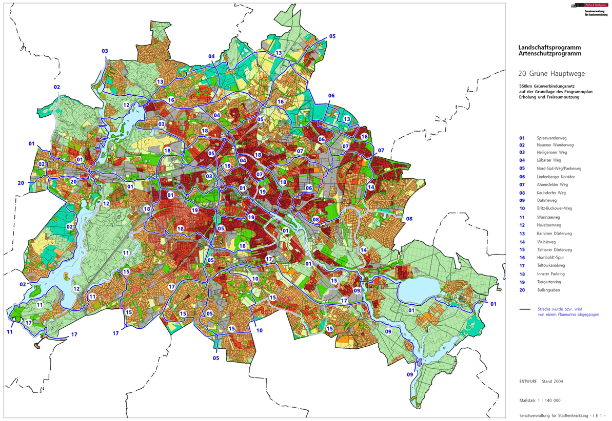
The Lübarser way is with the number 04 one of the 20 main routes green . This is a compilation of 20 hiking trails through the Berlin urban area with a total length of around 550 kilometers. The aim is to link “residential areas with the diverse recreational opportunities in parks and local recreation areas in Berlin and Brandenburg ” (Senate Department for Urban Development and the Environment). The pedestrian should have the opportunity to “experience the city intensely as a combination of culture, history and ecology”.
course
The Lübarser Weg follows with a length of 13 kilometers on part of the "Green Belt Berlin" on the former strip of the Wall from the city center on Bernauer Strasse, where there are further connections to Green Main Paths on the Wall Trail, to the Berlin Barnim in Lübars . This by the times to turn unbetretbare Wall Trail (from border and coastal path) has since been under landscape protection provided and so barely ten roads cross these reconquered by nature open space. Hikers can stroll along the tracks of the Berlin Wall between Bernauer Strasse and the fields of Lübars in the west and Blankenfelde in the east, almost undisturbed by car traffic .
Most of the Lübarser Weg runs between the districts that were separated by the Wall until 1990 .
Prenzlauer Berg

The Lübarser Weg begins at a town square in the south of the Mauerpark at the confluence of Schwedter and Oderberger Straße with Bernauer / Eberswalder Straße in the Prenzlauer Berg district . It starts from Hauptweg 19 ( Tiergartenring ), which is on Bernauer / Oderberger Straße. The Wall Trail on Bernauer Straße joins Lübarser Weg and both lead north through the Mauerpark along the course of the former Berlin Wall . At this corner between Gesundbrunnen ( West Berlin ) and Prenzlauer Berg ( East Berlin ) was at the Berlin Wall still a cornerstone of the action of the Berlin Wall. Lübarser Weg and Mauerweg lead through the park in the area of the former border installations, on the right the Friedrich-Ludwig-Jahn-Sportpark (Cantianstadion) and on the left the former freight station Eberswalder Straße. At the Gleimtunnel over Gleimstraße the paths continue in this green strip with the “Moritzhof youth farm” (children's farm). On the Schwedter Steg , a 220 meter long pedestrian bridge, over the section of the Ringbahn combined as the " Nordkreuz " and the two branches from Schönhauser Allee station (from the east) and from Gesundbrunnen station (from the west) to the Nordbahn and to Pankow . The path leads to the Behmstraße bridge , which is crossed to the right and on the descent with stairs down to Norweger Straße and under it. The Inner Parkring (Hauptweg 18) connects from Behmstraße .
The green main routes 04 and 18 - including the Wall Trail - run on Norweger Strasse , while Isländische , Ückermünder Strasse and Finnländische Strasse end there in front of the railway system. The underpass at the Bösebrücke leads to a green strip ( LSG ) of the former wall area between S-Bahn station Bornholmer Straße and the allotment gardens on the right (closest KGA 'Bornholm I'). the green strip is interrupted by the esplanade and the district is abandoned.
Pankow
At the corner of Dolomitenstraße / Esplanade you reach the Pankow district . Hauptweg 18 and Lübarser Weg lead to the left at Eschengraben through the railway underpass of the Stettiner Bahn (Pankower route) and through the second railway bridge of the Nordbahn (S-Bahn route to Wilhelmsruh and Wittenau and Tegel ) to Grüntaler Strasse . After the second railway underpass, the district is left.
A planned route of the Lübarser Weg goes between the two railway underpasses on the Postenweg east of the railway line over the "Nasse Dreieck", at its northern passage to Brehmestrasse and on this to the left to Wollankstrasse , this 50 meters to the left before the green belt over Wollankstrasse the railway bridge at the S-Bahn station .
Healthy well
After the railway facilities, the KGA 'Grüntal' is located in Gesundbrunnen , through which the Grüntaler Straße begins after 50 meters. At the passage through the median strip, Innerer Parkring (Hauptweg 18) to Grüntaler Straße and the Lünarser with the Mauerweg to the right into Steeger Straße . Sophienkirchhof III and Elisabth-Kirchhof II are located behind the western houses on Steegerstraße. At the end of this street is Wollankstraße , which is used to the right in front of the S-Bahn station through the railway bridge from Lübarser Weg. The Wall Trail remains in Gesundbrunnen and continues in Nordbahnstraße on the west side of the railway line . The Lübarser Weg leaves the district with the beginning of the bridge on Wollankstrasse.
Pankow

Under the S-Bahn bridge, Wollankstrasse is crossed to the “birch grove in the former death strip” behind it (labeled LSG), which leads to the left between the railway line and the houses on Schulzestrasse . Until 1961 there were tenant gardens of the houses that were converted for the construction of the wall and today the strip belongs to the birch grove, a reminder and reminder system. At the end of Schulzestrasse, Wilhelm-Kuhr-Strasse crosses in front of the fenced-in Panke basin, a flood-flooding area for the Panke . On the road comes the Wall Trail from Gesundbrunnen and the North-South Trail (main trail 05) that accompanies the Panke. The route goes to the right at the fence to the street Am Bürgerpark around the Pankebecken. The district boundary between Pankow and Niederschönhausen is in the Pankelauf, so the district is left on the bridge at the Bürgerpark .
Niederschönhausen
_Sch%C3%BCtzenstr.JPG)
The district of Niederschönhausen begins on the Pankebrücke . Here the north-south path leads into the Bürgerpark . The street Am Bürgerpark has a green strip on the right, on which the Lübarser and the Mauerweg are located. Until the need for the border installations of the Berlin Wall (front wall , Postenweg, back wall), this strip of land belonged to the Pankow III cemetery and was de- dedicated for the construction of the wall and the graves were reburied in the early 1960s. The fence on the left along the road delimits the disused freight yard Schönholz, which is located in Reinickendorf . At the end of the cemetery and the street Am Bürgerpark, turn left into Schützenstraße and then right into Buddestraße . This is initially an asphalt road, but goes straight ahead into a footpath that roughly corresponds to the Postenweg, next to it there is a plan of a watchtower. The Schönholz S-Bahn station on the left is in Gesundbrunnen. In addition, the district border between Reinickendorf (formerly West Berlin) and Pankow accompanies this green main path in accordance with the joint guidance of the Wall Trail and Lübarser Weg.
The Buddestrasse leads to the Provincial Road , which is crossed and the supermarket turned left to spring road . This following area next to the Schönholz colony (Waldsteg settlement) belonged to Reinickendorf until 1938 and was then assigned to Pankow. The border line hit at that time is always east of the railway line and sometimes extends a few tens of meters further. The area of the Berlin Wall with its additional systems was on the Pankower (East Berlin) side in a strip of around 60 meters. Through this area today with the intention of being a “birch grove on the former death strip”, it leads through green, sometimes wild, forest areas mostly with birch trees. The roads that were interrupted between 1961 and 1990 now lead through again and are crossed like Klemkestrasse . Whereby the route line mainly follows the district boundary. After Klemkestrasse and next to the KGA 'Straße vor Schönholz', you will go through a grove of birch trees that has grown since 1990, where the platform's own homes were located, of which the remaining location of the “Kolonie Schönholz” settlement up to the Waldsteg was still today testifies. Within this wood at the level of the extension of road 78 , the district boundary is and you leave Niederschönhausen.
Wilhelmsruh
_Kopenhagener-Mauerweg.JPG)
Along the embankment, you will reach the Wilhelmsruh district 200 meters before Copenhagener Strasse . Some barracks on the railway line the district boundary to Reinickendorf up to 30 meters from the railway embankment. The Lübarser Weg and the Hauptweg remain on the Pankower side. Over the Kopenhagener Straße, past the exit of the Wilhelmsruh S-Bahn station , the path located here continues along the embankment and along the district border. The departure station of the Niederbarnimer Railway (Reinickendorf – Liebenwalder – Groß-Schönebecker Railway) was formerly located next to today's station . The railroad track and the station part no longer exist. This turning railway line was later the industrial siding of Bergmann-Borsig , today: PankowPark. The Lübarser Weg leads along this line to the left past the commercial buildings and industrial halls, partly also to the area of the Reinickendorf district, which extends over the railway site. The only 20 meter wide green corridor on the way is marked as a landscape protection area. The Nordgraben and the Heinz-Brandt-Straße , which was built on the former strip of the wall and which was to become part of the northern bypass, will be about 1.5 kilometers from Kopenhagener Straße . Here the Lübarser Weg meets the Humboldt-Spur (Hauptweg 16), which immediately leads over the Nordgraben-Platte next to the railway on its north bank to the Märkisches Viertel in a parking strip south of the houses on Dannenwalder Straße . The Lübarser Weg and the Mauerweg lead to the right on the Heinz-Brandt-Straße on the south bank of the north trench, and lie along the fence to the ABB site . At the end of Heinz-Brandt-Strasse, Lübarser Weg uses the “(industrial) railway bridge over the Nordgraben” and, as the Nordgraben Wilhelmsruh is limited, it leaves the district.
Rosenthal
_WilhDamm_BahnNord.JPG)
When you cross the north ditch, Lübarser Weg reaches Rosenthal . Here the main path 04 crosses the Humboldt track again. The further course to Wilhelmsruher Damm uses the path on the track on the west side accompanied by the Märkisches Viertel. The planned tour of Lübarser Weg is to remain 150 meters on the Wilhelmsruh side and then lead over a missing bridge at the edge of the KGA 'Kolonie Gauert' into the tree / bush strip of the former wall strip with the border facilities , immediately along the Wilhelmsruh cemetery between Uhlandstraße . From the crossing of the Wilhelmsruher Damm and the subsequent crossing of the Rosenthalgraben, the Lübarser Weg is still close to the track, with the route being a little over the district border in the Märkisches Viertel. A wild scrub of trees and bushes has emerged from the former strip of the wall, which is also designated as LSG. After the western tour, Lübarser Weg changes to Quickborner Straße on the east side, Rosenthal. Here was the abandoned Rosenthal train station of the Heidekrautbahn . The green strip on the Wall Trail is designated as a landscape protection area and lies between the railway and allotment gardens to the north-northeast on the Rosenthal side. Opposite is the industrial and commercial area of the Zerpenschleuser Ring . Lübarser Weg is located in forest and fallow land between the railroad track and the KGA 'Rosenthal-Nord' and goes next to road 127 , which is built on with residential buildings on the east side, on Centweg and road 126 past allotment gardens that have been rededicated as building land. In this green strip, Lübarser Weg lies to the west of the Rosenthal cemetery, on the northern edge of which the route of the former Tegel – Friedrichsfelde industrial railway crosses . Here the district is left.
Blankenfelde
At the transition from Lübarser Weg over the industrial railway line, there is also a change from the built-up area in Rosenthal to the field landscape of Blankenfelde . Until around 1980 the sewage fields of the Rieselgut Blankenfelde were located here next to the Lübarser Weg. On the Reinickendorfer side, the district change from Märkisches Viertel to Lübars takes place on this former industrial railway line. The Lübarser Weg runs together with the Wall Trail initially for 580 meters on the tracks of the Heidekrautbahn . Halfway along the Priestergraben , the path changes from the east to the west side of the tracks. Here is the Lübarser Höhe in the Lübars Leisure and Recreation Park 85.3 m above sea level to the west . To see NN . The district border Pankow - Reinickendorf leads 100 meters after the industrial railway away from the Heidekrautbahn to the north. The Lübarser Weg, as a wall path, is located on the eastern edge of the former death strip about 60 meters from the district border in the Pankow area. We continue on the Blankenfelder Bahnhofstrasse , formerly road between Blankenfelde and Lübars, 60 meters east of the boundary line is crossed on open fields. At the border town the “ Checkpoint Qualitz ” stands for the breakthrough of the Wall on November 9, 1989 . Going straight ahead, it crosses the Schildower Weg 640 meters north of Bahnhofstrasse and 200 meters after the change from the landscape protection area from Feldflur to the NSG 'Tegeler Fließ', on which the Barnim Dörferweg lies between Blankenfelde and Lübars. The Wall Trail is still straight on the way west on the Köppchensee to the state border. The Lübarser Weg turns left with the Barnimer Dörferweg. The district is left on this section of the path.
Lübars

Using the Schildower Weg, the Lübarser Weg leads together with the Barnim Dörferweg 50 meters after turning off the Mauerweg in the district of Lübars . This meadow path is located south of the meadows around the Sprintwiesenteich and reaches Blankenfelder Chaussee at the entrance to the village and Alt-Lübars to the right . The Lübarser Weg ends here in the village center on the Anger with the village church , school and fire brigade opposite the Dorfkrug.
Local transport connections
The connections to the public transport are preferably on the north-south railway.
- Wilhelmsruh S-Bahn station ,
- Schönholz S-Bahn station ,
- Wollankstrasse S-Bahn station ,
- Bornholmer Strasse S-Bahn station ,
- Eberswalder Strasse underground station .
literature
- Hiking map Berlin City. Strolling - walking - hiking . 1st edition. piekart, Berlin 2012, ISBN 978-3-935863-22-3 .
Web links
- 20 Green Main Paths , website of the Berlin Senate Department for Urban Development and the Environment, accessed on January 5, 2014.
- Overview map of the 20 hiking trails , website of the Berlin Hiking Association, accessed on January 5, 2014.
Individual evidence
- ↑ a b path number: 4
- ↑ FUSS e. V.
- ↑ The BUND project "20 Green Main Paths"
- ↑ Project "20 Green Main Paths® in Berlin"
- ^ Association for hiking in the LSB Berlin
- ↑ Senate Department for Urban Development and the Environment , Unit IE Nature Conservation, Landscape Planning and Forestry
- ↑ Chronicle of the 20 green main routes on berlin.de
- ↑ 20 main green paths. In: Website of the Berlin Senate Department for Urban Development and the Environment. Retrieved January 31, 2017 .
- ↑ The BUND project “20 main green paths”. In: BUND website . Retrieved January 31, 2017 .
- ↑ Green corridors for Berlin: The Wet Triangle
- ↑ Berlin city map 1907: Reinickendorf-Liebenwalde station
- ↑ City map Berlin 1955: Wilhelmsruh S-Bahn station
- ↑ a b FIS Broker map display 20 green main routes - digital hiking map , since May 2014 the recommended routes have been marked in blue, plan routes that can be walked on are red and, if they are not walkable: dashed red

01 Spreeweg | 02 Spandauer Weg | 03 Heiligenseer Weg | 04 Lübarser Weg | 05 North-South Path | 06 Lindenberg Corridor | 07 Hönower Weg | 08 Kaulsdorfer Weg | 09 Dahmeweg | 10 Britz-Buckower Weg | 11 Wannseeweg | 12 Havelseenweg | 13 Barnimer Dörferweg | 14 Wuhletal hiking trail | 15 Teltower Dörferweg | 16 Humboldt track | 17 Teltow Canal Path | 18 Inner parking ring | 19 Tiergartenring | 20 Bullengrabenweg