
North-South Way (Berlin)
| North-South way | |
|---|---|
 Marking at the Pankebrücke in Blankenburger Bahnhofstraße as Hauptweg 05 (also Pankeweg) |
|
| Data | |
| length | 40 kilometers |
| location | Berlin (green main path) |
| Supervised by |
FOOT e. V. BUND-Berlin Citizens' Project "Network" Berliner Wanderverband Stadtentwicklung |
| Markers |
 Blue field, white "5" Blue field, white "5"
|
| Starting point |
Book - Stener Bruch 52 ° 38 ′ 44.5 ″ N , 13 ° 31 ′ 11.5 ″ E |
| Target point | Grove at Königsgraben 52 ° 23 ′ 12.2 ″ N , 13 ° 23 ′ 48.2 ″ E |
| Type | trail |
| Height difference | very low |
| Level of difficulty | inner city way |
| particularities | Route from north to south through the center of Berlin, in the north is the Pankewanderweg as part of the Berlin-Usedom long-distance cycle route |
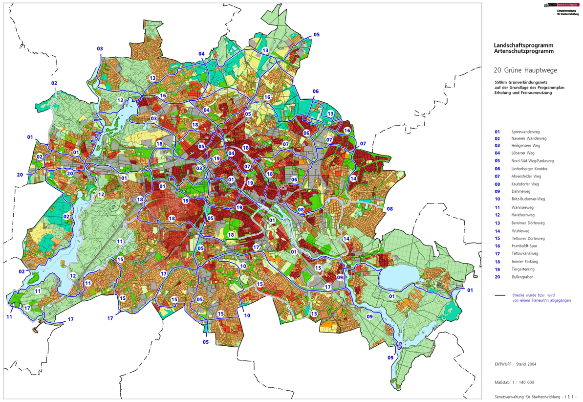
The north-south route with number 05 is one of the 20 main green routes . This is a compilation of 20 hiking trails through the Berlin urban area with a total length of around 550 kilometers. The aim is to link “residential areas with the diverse recreational opportunities in parks and local recreation areas in Berlin and Brandenburg ” (Senate Department for Urban Development and the Environment). The pedestrian should have the opportunity to “experience the city intensely as a combination of culture, history and ecology”.
course
The north-south route runs 40 kilometers through Berlin, initially in the north along the Panke to where it flows into the Spree in the city center. This part is called the Pankewanderweg separately . From there it goes further south through the park at Gleisdreieck , the nature park Schöneberger Südgelände and to the regional park Teltow Park. The southern border of Berlin is reached in Marienfelde . Favored by the opening of the park on the track triangle , the path between the stations takes Yorckstraße and Suedkreuz by green areas and paths compounds where the Tempelhof-Schöneberg and the historical center are directly connected.
The location of the paths can change at short notice due to city life.
book


The north-south path begins in Buch in the north of Berlin on the Stenerbruch , a wet meadow area on the course of the Panke . It is part of the Berlin – Usedom long-distance cycle route , which is part of the Pankewanderweg between Bernau and downtown Berlin . The entrance to the north-south route is on the border with the municipality of Panketal , in the district of Röntgen . With the S-Bahn station Röntgengental there is a connection to the Berlin rapid transit system . From the exit the path leads to the right to Bahnhofstrasse and then to Stenerbuschstrasse and in Berlin area south of the Panke on the route through the meadows of the Stenerbruch. The change to the other bank of the Panke takes place at the level of the 'Buch Kolonie' settlement ( street 5 ). Further on, past a piece of forest, before the Pölnitzweg, the route leads 60 meters to the right to the entrance to the Buch Castle Park . The park path leads through this between the railway line and the watercourse of the Panke to Wiltbergstraße with the Buch train station . Through the “Kauflandschaft” on the southern edge of Wiltbergstrasse, it goes back to the right bank of the Panke. The Moorlinse in Buch is located sideways on the Pankewanderweg . The further riverside path, in particular the following bank change because of an overgrown railway embankment, the former branch of an industrial railway station and the old railway bridge over the Panke are difficult to walk on. The pedestrian bridge from the sports field to Walter-Friedrich-Straße and the path around the Marianne-Buggenhagen-Schule are used. At Ernst-Busch-Straße it goes back to Panke and over the Robert-Havemann-Steg through the following railway underpass to the west side of the Stettiner Bahn to a "farm road". The path leads to the left, with a small detour to the right, the moor lens is in view. A pedestrian bridge created as a result of the expansion of the long-distance route in 2010 goes over the motorway ring . After the Panke has flowed through the autobahn, the path leads back on the bank through the NE 27 railway bridge to Basdorf . The NSG Karower Teiche is directly connected to this railway line on the right-hand side, Karow lies across the Panke , the main path remains on the Bucher side. At the Schönerlinder bridge crosses Lindenberger corridor (main road 13) the north-south route. Allotment gardens are located on the opposite bank (KGA 'Bullenwiese', KGA 'Rübländer Graben', KGA 'Kastanienhain'). The district of Buch im Graben ends at the mouth of the Lietzengraben from the right (west) into the Panke.
French Buchholz

With the mouth of the Lietzengraben, the north-south French route reaches Buchholz . Between Panke and the nature reserve, the route continues south over the Pankgrafenbrücke ( Pankgrafenstraße ). Before that, some trenches from Rieselfeld times still find their way to the Panke. From the Pankebrücke it goes through an open meadow landscape with the Wagendorf. Opposite the Panke in Karow KGA 'Pankeniederung'. The path to the right of the Panke ends at the Buchholzer Graben , which was created to divert the sewage field ditches that were blocked in this way when the Berlin outer ring was built . At Buchholzer Graben, the Krontaler Steg was built in connection with the Pankewanderweg, on which the district to Krontaler Straße is left.
Karow

The district Karow is reached by crossing the Panke on the Krontaler Steg to Krontaler Straße. This left it goes through the Flaischlenbrücke . This three-part railway bridge is no longer in Karow, but in Blankenburg.
Blankenburg
The district of Blankenburg is reached with the three-part railway bridge . A single-track bridge as a north-turn to the Szczecin Railway , the middle outer ring bridge and the double-track S-Bahn bridge (S-Bahn line S8) that connects to the south of the Szczecin Railway bridge Krontaler Straße and the Pankelauf. The small pedestrian bridge to Buchholz also bears the name Flaischlenbrücke and probably gave the name to the large railway bridge. When you turn off Krontalerstraße, you leave it on a path along the banks of the Panke, where the Brendegraben joins the Panke from the other side. Since the entire width of the Panke, including the right bank, belongs to the neighboring district, Blankenburg will again be abandoned to French Buchholzer Flur.
French Buchholz (2)

Next at Panke shore and after their passage through the feeder road Pankow along this lärmschutzwandversteckten motorway, in a sharp bend to the left along the ramp of the king bridge up to the Flaischlenstraße again after Blankenburg deviated to the start of the bridge ramp extension of the Königstein road to reach. This high bridge over the Autobahn and Panke, also suitable for cyclists (long-distance cycle route Berlin-Usedom), has long and therefore less steep driveways on both sides. At the western end of the bridge, French Buchholz is reached again. With a short descent at the KGA 'Pankewiese II', the green main path (here: Pankeweg) reaches the Panke (protected by the motorway via a green strip and noise protection paths). The KGA 'Gravensteiner Aue' follows on the Buchholz side. What is striking is the Laake , which passes through the motorway in a pipe to the Panke, whereby the motorway was laid over the Freischützbrücke. Pankeab to the allotment gardens of the Gravenstein recreation area is the midwife bridge, in the style of the Königsteiner bridge with long ramps. According to legend, the 'Midwife Path' was used by this professional group between Blankenburg and Buchholz before the motorway feeder was built. The extension of this path is the Eiserapfelweg , the plant paths of the Gravenstein settlement were consequently given street names according to apple varieties when the nationwide georeferencing of properties was implemented in the Pankow district . The allotment gardens 'Pankegrund', 'Pankewiesen' and 'Pankepark' follow. There is a pumping station here (Ferdinand-Buisson-Strasse) and the other buildings belong to the Pankstrasse commercial center; at the commercial park after the former leather factory, Pankeweg comes to Bahnhofstrasse . The Bahnhofstrasse bridge is 300 meters from the Blankenburg S-Bahn station to the left. The north-south path leads over the bridge 30 meters to the left to the further course on the eastern bank, the path on the Panke. At the Panke Basin, the north ditch is diverted with a lock system . 150 meters further crosses the green Hauptweg 16 , which here uses the route of the former Tegel – Friedrichsfelde industrial railway . The green main path 05 leads between Panke-Ostufer and Blankenburger Karpfenteichen to junction 4 ( Pasewalker Straße ) of the A 114 , where the confluence of the Schmöckpfuhlgraben into the Panke is. It is recommended to walk around the crossing to the left, as the further course of the main path is planned in the immediate vicinity of the Panken. The Panke flows after the Schmöckpfuhlgraben is gemündet where Pasewalker road through the spoon bridge . However, since the other properties border the Panke, the main path continues on the left sidewalk through Schlossallee . After about 40 meters, you will leave the district in its southern tip on Schlossallee.
Niederschönhausen
After reaching the district of Niederschönhausen , the north-south path leads on the south side of the Schloßallee between old trees and town villas ( Grumbkow- , Christinen-Elisabeth- , Lindenberger Straße ). Then you have reached the park of " Schönhausen Palace in Niederschönhausen" at Lindenberger Strasse. The ideal path here would open up from the north bank of the Panke at the height of the Strauchwiesenbrücke to Schlossallee. The KGA 'Schüßler' (in the Pankow district) is initially on the left. In the castle park, the Panke leads back to the main path and accompanies it to the edge of the park on Ossietzkystraße . The tour in the district ends at the castle park for the time being.
Pankow

As soon as the Ossietzkystraße is entered, the district of Pankow is reached. From Elisabethweg 3, there is also planning to lead the north-south path between properties (formerly: Pankow-Städtchen) and the Pankenordufer, again in Niederschönhausen. The north-south path leads through Elisabethweg and Parkstraße to Schönholzer Straße , over this and Kreuzstraße to the Bürgerpark . At the eastern park footbridge over the Panke, with the connection to the ideal tour, you reach Niederschönhausen again.
Niederschönhausen and Pankow
Since the Panke separates the districts of Pankow and Niederschönhausen, the change of side of the path on the eastern Parksteg is also a change of district. On the northern bank, the main path leads through the Bürgerpark to the street Am Bürgerpark . When you leave the public park at the playground, Lübarser and Mauerweg meet, which run on the street at Friedhof III in the former border strip. When you change the side of the street Am Bürgerpark and over the “Brücke am Bürgerpark”, the main path is again located in the Pankow district for 270 meters. It's about the flood retention basin, formerly located directly between the Wall, at the fence in Wilhelm-Kuhr-Straße and through the railway bridge ( Berliner Nordbahn , today S-Bahn near Wollankstraße station ). The Lübarser Weg goes in the 'birch grove on the former death strip' in front of the railway line to the east, the Wall Trail also leads through the underpass and then turns left.
Healthy well

Directly to the underpass of the Wilhelm-Kuhr-Straße under the north runway at the Nordbahnstraße is Gesundbrunnen enter. This leaves the Pankow district and reaches Mitte . The north-south path and thus also the Pankewanderweg lead to the right over the Hugo-Heinemann-Brücke to cross the Panke and at the corner of Kühnemannstraße to the left into the hiking path that was laid out here as Walter-Nicklitz-Promenade in the 1970s , which was expanded into a long-distance cycle path in the years after the political change . A parking strip was created along the Panke, with the local recreation path changing the banks of the Panke a few times. The KGA 'Panke-Grund' is on the right and the path leads around the retention basin to the east and borders on Kirchhof III of the French community. At its southern edge, the Inner Parkring crosses the North-South Path and the Panke. The north-south path in the park lane on the east side of the Panke crosses Soldiner Straße , at the level of Gotenburger Straße , before Stockholmer Straße again alternating the bank, it goes 'right-wing' to Osloer Straße with tram traffic.
The wide Osloer Straße, part of the road ring in extension of Seestraße, is crossed alternately on the Osloer Straße Bridge in the train from Stockholm to Travemünder Straße. Next, the hiking trail reaches Badstrasse . This road is best to rechtsks on the bath bridge going to the intersection with traffic lights Badstraße for Military Exercise / Sweden- / Koloniestraße crosses and turn on the bath bridge to the left to Panke back. Then turn right into Gropiusstrasse . Between Thurneyserstrasse and Schönstedtstrasse , with Orthstrasse in it, lies the park around the district court of Wedding ( Brunnenplatz ). This is followed by a green strip at the district and finance court and the Albert-Gutzmann-Schule along the Panke, past the Walter-Röber-Brücke (Wiesenstrasse, Uferstrasse), on which a memorial stone for Weddinger Blutmai is embedded. On the Pankstrasse bridge over the street of the same name , it goes through a green area, where previously Weddinger apartment buildings stood right up to the “Stinke-Panke”. Across from the Panke is the Herbert Hoover School. The north-south path is located under the Ringbahn underpass on a section of the path with partly abandoned commercial operations, where an impression of the Panke in Wedding is created, even if some of it is greened and embellished today. A newer bridge bridge complements the view. The green corridor between Court Street Bridge and Schönwalder Street Bridge is again a green corridor on Panke shore.

At Schulzendorfer Strasse, the main path leaves the visible Pankelauf into the following green corridor to Chausseestrasse. At the Schulzendorfer Strasse computer system, the water from the Panke is divided into the canal in the course of the “Charitegraben” and a junction gives the possibility of the actual still unfinished [outdated] Pankelauf, now called Stadt- or Südpanke. The path then follows the invisible (because piped) course of the Südpanke through the park of the Südpankepark towards the corner of Liesenstrasse and Chausseestrasse. Parkweg itself reaches Chausseestrasse 70 before the intersection .
Wedding
At the Chausseestrasse, the district of Wedding is reached with the Südpankeparkweg , which extends here on the Chausseestrasse into the district of Mitte . The water of the Panke is led through by a culvert under the street and the U6 underground line running along it. Another tour along the Südpanke to the center between the Bundeswehr hospital and the headquarters of the Federal Intelligence Service is planned, but is currently not accessible. The north-south path on Chausseestrasse leads to the right to the green corridor on the Weddinger side of Boyenstrasse . Hauptweg 19 ( Tiergartenring ) and the Wall Trail will be included on this tour. At the end of Boyenstraße turn right away from Scharnhorststraße in An der Kieler Brücke and turn left at the houses to the left in the direction of Kieler Brücke on the district boundary of Wedding / Mitte (both in the Mitte district ). At the Kieler Brücke there is also the Heiligenseer Weg on the shipping canal . The three green main routes 03, 05 and 19 including the Wall Trail are located on the “Promenade on the Berlin-Spandauer Schifffahrtskanal” green corridor and lead out of Wedding.
center

A little from the Kiel Bridge on the north bank of the shipping canal, here on the Charitégraben , the north-south path has reached the district of Mitte . Around the helicopter landing pad of the Bundeswehr hospital and on Kieler Strasse , the main routes lead to the Invalidenfriedhof with historical gravesites of the military. Since the cemetery was in the area of the Berlin Wall , some losses were incurred. In the Invalidenfriedhof, the north-south path to Scharnhorststraße separates from the canal promenade through the exit Scharnhorststraße and left into Habersaathstraße to Schwarzen Weg . From here the path through the park on the southern slope is accessible.
The green main path 05 leads on the black path at Invalidenpark with the monument 'Sinkende Mauer' next to the buildings of the federal ministries to Invalidenstraße , within sight (700 meters) the main station . Crossing the Invalidenstraße to the square in front of the Neuer Tor and over the through Hannoversche Straße to the Robert-Koch-Platz it goes left through the Hannoversche to the Hessische Straße. At the ditch on the right it is possible to look back at the built-up Panke bridge of the Hannoversche Strasse to the Hessische Strasse. Along the canalised Südpanke next to the primary school 'Neues Tor' it goes to Philippstrasse.
Here, too, there is an ideal route along the Südpanke through the courtyard of the institutes of the Humboldt University on Pankegraben behind the theaters and the embassy of the Ukraine and the Reichsbahnbunker further on over Reinhardtstrasse and between its houses to the site of the old Friedrichstadtpalast ( Am Zirkus ) Bertolt-Brecht-Platz . The recommended route uses the path at the high-rise of the clinics on the Charité-Mitte campus to Luisenstraße and this to the left to Schumannstraße, past the Kammerspiele and the Deutsches Theater and to the right to Albrechtstraße in front of the Ukrainian embassy (opposite the Charité canteen) and around behind the Reichsbahnbunker. Crossing Reinhardtstraße 60 meters to the left, you will reach the Schiffbauerdamm at Am Zirkus and in this way Bertolt-Brecht-Platz. Here, next to the Berliner Ensemble (Brecht Theater), the Stadtpanke flows into the Spreekai opposite the Friedrichstrasse train station (at the Tränenpalast ): “At Schiffbauerdamm number two the Panke flows into the Spree”. Accordingly, the Pankewanderweg ends as part of the north-south path.
The north-south path on Schiffbauerdamm is directed to the right (towards the Spree) through the railway bridges at the train station, further between the Spree and federal institutions to the Marschallbrücke, over which the Wall Path (from the other side) also changes the banks of the Spree. With the change from Luisenstrasse to Wilhelmstrasse over the bridge, the Reichstag embankment is reached and here meets the Spreeweg / Berliner Urstromtal . The north-south path and the wall path turn south at Friedrich-Ebert-Platz , east side of the Reichstag building , opposite the Bundestag administration in the Jakob-Kaiser-Haus . The Spreeweg continues along the banks of the Spree. Opposite the Reichstag is the Reichspräsidentpalais with the corridor that was used during the Reichstag fire . At the end of the Reichtstag building, Dorotheenstrasse / Scheidemannstrasse , you leave the district by changing over the streets to the Tiergarten .
Zoo

When you enter the park, you enter the Tiergarten district of the same name in the Mitte district. At this corner of the park is the memorial for victims of the Berlin Wall and the memorial for the Sinti and Roma who were murdered under National Socialism . In the park on the way towards Ebertstraße across the Straße des 17. Juni and at the Brandenburg Gate (behind it Pariser Platz ) with the Platz des 18. März in front of it, the north-south path leads with the Wall Path and from here with the long-distance hiking path E11 in the zoo to the south. Opposite is the memorial for the murdered Jews of Europe and in the park the memorial for homosexual victims of fascism . Leave the Großer Tiergarten at Lennéstraße ( Lenné triangle ) and the long-distance hiking, wall and main paths run in front of the buildings on the sidewalk from Ebertstraße to Potsdamer Platz . In addition to the Holocaust memorial on the street in the Ministergärten , the six state representations of German federal states are opposite . The B 1 (Leipziger / Potsdamer Strasse) crosses at Potsdamer Platz with the long-distance and S-Bahn train stations and the underground station . The Mauerweg then turns diagonally to the left into Stresemannstraße and the Fern- and Hauptweg continues a little to the right in Tilla-Durieux-Park on Gabriele-Tergit-Promenade , at the southern end of which is the Mendelssohn-Bartholdy-Park underground station . Before the Landwehr canal lying B96 (here the Reichpietschufer ) ends of the district.
Kreuzberg
_20.jpg)
The district of Kreuzberg is entered with the Reichpietschufer, with a change over the district border Mitte / Friedrichshain-Kreuzberg . To the east of the underground station is the Mendelssohn-Bartholdy Park of the same name with the large Mendelssohn-Bartholdy stone . This boulder is designated as a natural monument and shows a portrait of the composer Felix Mendelssohn Bartholdy .
A bridge that will enable the transition from the Reichspietsch to the Schöneberger Ufer within the park strip is planned. For the time being, the Köthener bridge next to the subway bridge to Schöneberger Ufer will be used, with traffic lights in both directions on federal highway 96 . On the Schöneberger Ufer, the north-south path crosses the Tiergartenring and the long-distance hiking path joins this eastwards on the Landwehr Canal. The main path 05 leads again the same length to the right and then on the former railway site in the park at Gleisdreieck -Westpark. The railway tunnel from Potsdamer Platz station to Südkreuz is located under this park . To the left of the path is the Gleisdreieck underground station and between the two underground bridges ( lines U2 and U1 ) this stretch of the Dresden railway comes to the surface. The main path changes to the tree-lined “Gleisdreieck-Ostpark”, here is the museum pond and behind it the technology museum . At the southern end of the east park, the Yorckstraße with the Yorckbrücken and thus the end of the district is reached.
Schöneberg

With the Yorckstraße the district's Schöneberg in the district of Tempelhof-Schöneberg enter. S-Bahn, long-distance train and the track of the museum train to the Monument Hall are on the bridges. One of the bridges is open for use on the main path. Here it goes into a fallow and meadow area between the commercial buildings on Kreuzbergstrasse and the long-distance railway tracks to the Monumentenbrücke .
To the right over the bridge into Monumentenstraße, there is now a descent to the bike and footpath to the south parallel to the train tracks, in contrast to the original route. This leads under the column bridge. Immediately on the right is the building of the German Institute for Structural Engineering , and on the opposite side the impressive building of the heavy load structure from the early 1940s. Continue past the Hertha-Block-Promenade ( Alfred-Lion-Steg ) to the Südkreuz train station, whose entrance hall has to be crossed. Hildegard-Knef-Platz is on the other, western side of the station building .
The designated main route is still on the street: Monumentenstrasse, to the left, Hohenfriedbergstrasse, to the right, Kolonnenstrasse, at the intersection to the left, Naumannstrasse (past the Twelve Apostles Cemetery on the left). At Leuthener Strasse, which runs across Leuthener Platz, to Hertha-Block-Promenade, turn left (eastwards) for 270 meters into Torgauer Strasse and to Wilhelm-Kabus-Strasse , where the currently inaccessible guidance at the Bahngrünzug opens up again. Hildegard-Knef-Platz , the western station forecourt of the long-distance and S-Bahn station Südkreuz , is reached with the railway bridge (S-Bahn lines of the Ringbahn) over Wilhelm-Kabus-Straße .

Via this space along the buildings and to the parallel Lotte-Laser-Stein-Straße under the driveway to the parking garage of the train station, a new section of the path leads to the pedestrian (and cycle path) bridge ( Sachsendammsteg ) directly next to the railway facilities at the south exit of the Railway station on the north-south route with the bridge over Sachsendamm and the city motorway . Continue in the green corridor on the railway site, on the right side of the path open-air laboratory / student garden / orchard, then the KGA 'Luisengarten', 'Glück im Winkel', 'Bergfrieden', 'Lindenbaum' and Friedhof Priesterweg , KGA 'Lindenhain', 'Neue Zeit', 'Reunification', 'Wiesengrund', 'Rabbit Farm', 'Alte Ziegenweide' the main path runs through the elongated Hans-Baluschek-Park . At the level of the Matthäifriedhofsweg , a footbridge leads over the tracks to the LSG Naturpark Schöneberger Südgelände with an embedded nature reserve and the 50 meter high iron water tower of the Tempelhof marshalling yard . The main path remains west of the railway and leads to Priesterweg at the station Priesterweg and near the railway to Prellerweg . The Insulaner ( 75 m above sea level ) with satellite observation station and Wilhelm Foerster observatory is located across this street . Staying on the Prellerweg at the railway into the Sembritzkistraße , it goes along the Tempelhof district boundary. At the edge of the Insulaner to the right away from the track, the main path leaves the district, where the allotment garden 'Sembritzkiweg' begins on the left and the park around the mountain ends on the right.
Steglitz

On the Sembritzkistraße 70 meters is in front of the northern section of the Oehlertrings the local situation south end in the district of Steglitz from Steglitz-Zehlendorf reached.
In the further course Brinkmannstraße follows as a cross street, on the right side the former house of Arnold Schönberg in the Sembritzskistraße with the house number 33, the southern section of the Oehlertring (with the former house of Jochen Klepper at house number 7), the Gurlittstraße , on the right hand the Jochen Klepper Park and the “Elementary School on the Insulaner” on Hanstedter Weg . At the square with the music school, turn left into Grabertstraße and on the left past Karutschenpfuhl and Karl-Fischer-Weg and Hambuttenpfuhl opposite Sohnreystraße to Steglitzer Damm opposite the Südende S-Bahn station .
To the left into Steglitzer Damm over the Steglitzer-Damm-Brücke and immediately afterwards right into Crailsheimer Straße , the main path leads to the next cross street to the left, Ellwanger Straße and past the Protestant church for the Second Coming of Christ over the Hünefeldzeile to the left into the Biberacher Path and right again on Steglitzer Damm to Attilastraße . Leave Südende at the railway bridge to the left, south of Attilastraße S-Bahn station .
Tempelhof

At the S-Bahn station Attilastraße you reach the Tempelhof district on the street of the same name at the railway bridge . In total, only 350 meters of the main path are in this district. On Attilastraße through a total of four single-track railway bridges, the fourth being untracked. After changing over the Attilastraße, there is a protected green area directly on the railway site (in front of the Ringstraße ) and on the way to the KGA 'Erntesegen' and next to the railway agriculture to the bank of the Teltow Canal and to a pedestrian bridge (No. 28) over it. This bridge is to the west of Mariendorf harbor and to the west of it is the S-Bahn bridge . Before that, the Teltow Canal Path is crossed on the north bank . Since the Teltow Canal belongs to the district here, Tempelhof is left at the end of the bridge over the south bank path.
Mariendorf

From the southern bridgehead of the pedestrian bridge next to the railway bridge of the Dresdener Bahn , the north-south path is in the Mariendorf district in the Tempelhof-Schöneberg district . The Idealweg leads here to the right of the canal through the railway bridge and then in Lankwitz around the allotment gardens 'Lankwitz Hafen' in front of the tank farm in Wunsiedler Weg . The stretch of shore next to the port of Lankwitz (oil port) is not accessible, however. The green main path 05 therefore continues along the railway farm along the edge of Marienfelde. To the left is a solar energy field (south of the Mariendorf harbor). Further south, the former Mariendorf gasworks is next to the path and you will reach Lankwitzer Strasse , which is used to the right to the Lankwitzer Bridge . Leave the Mariendorf district on the bridge at the upper end of the railway site.
Lankwitz
.JPG)
The north-south route reaches the Lankwitz bridge on the Kamenzer Damm and here on the Lankwitz area . On the southern sidewalk past Haynauer Straße, the main path opposite Dittersbacher Weg turns left into the allotment garden 'Alt-Lankwitz'.
Except in the initial bank area, the plan variant is accessible and begins in the district on the Teltow Canal. From the allotment garden 'Lankwitz Hafen' leads from Wunsiedler Weg south of Schneebergstraße to the left through an accessible green corridor (past Bernecker Weg, Döhlauer path) over Alt-Lankwitz to Kamenzer Damm and on this left to Dittersbacher Weg.
The allotment garden 'Alt-Lankwitz' is an elongated allotment garden colony to the left of the Haynauer Straße industrial area and to the right of the Von der Auferstehung Christi community center , the Halbauer Weg student residence, the Ludwig-Bechstein primary school and the Kiriat-Bialek sports facility on Keffenbrinkstraße . The north-south path continues as a park path through a green corridor parallel to Wichurastraße, interrupted by Belßstraße and across it. The Gartenaue settlement is on the left-hand side of the path. To the south of Emmichstrasse , the Lankwitz campus of the Free University of Berlin (formerly Berlin University of Education ) follows on the right as far as Preysingstrasse . This green corridor has its course through a tributary, which lost its guidance with the construction of the Teltow Canal. Further south, this green corridor between Pappritzstrasse and Weygerweg turns to the west (curved to the right), the main route leads south on Malteserstrasse . At the corner of Marchandstrasse, a three-kilometer-long green corridor branches off to the west, which leads to Lilienthalpark , where, after two kilometers on Sondershauser Strasse, you meet Teltower Dörferweg , the green Berliner Hauptweg with number 15.
After 120 meters you will see the entrance to the Luther cemetery at the cemetery chapel on the right and continue on the main path of the cemetery to the opposite exit on Tambacher Straße . About 50 meters after entering the cemetery you will find the grave of the former Berlin Senator Klaus Riebschläger on the crossroad on the right . About halfway to leaving the cemetery is the memorial stone for the Berlin original Harfenjule on the right in the central square . The connecting path to the left before the cemetery exit is the last possibility to get to the neighboring Kreuz-Friedhof . Leave the district at the southern end of the cul-de-sac where the exit to the cemetery is located.
Marienfelde

Marienfelde is reached from the southern end of Tambacher Strasse within sight of the two-story apartment block at Maximilian-Kaller-Strasse 1–21a (odd) and the playground . Between the residential areas, the path leads over green areas and 30 to 60 meter wide green and park strips to the monastery pond at the Church of the Good Shepherd and the Catholic School St. Hildegard . To the south of the pond, Maximilian-Kaller-Strasse turns into Dr.-Jacobsohn-Promenade and the north-south path over it. He turns right into the green areas of the residential buildings and uses the passage through Maximilian-Kaller-Straße 14. Here, in turn, you will reach a green area (playground) behind properties on Weskamstrasse, which leads to the left. It is the Hildburghauser road continues, crossing, in the green corridor between Kita and "Marienfelder School" (Maltese Primary School and Alfred Adler Elementary School) behind the land of Waldsassener Street continued the way. The Teltower Dörferweg (green main path 15) crosses on the west side at the level of Lichterfelder Ring . Both main routes share the green strip between the residential buildings to the south. The Tirschenreuther Ring is crossed and the two main routes in the green corridor turn to the southeast and reach the B 101 , Marienfelder Allee .
This 30 meter wide five-lane road with two sidewalks has to be overcome to the opposite park path next to the parking lot. The path leads through the KGA Amstelveen to the Schlehenberg (a former mountain of rubble) and continues on the Parkweg in front of the KGA 'Am Diedersdorfer Weg' (a seven-meter-wide asphalt path) into the Marienfelde amusement park . The two main paths remain on the park path at the edge (around the nature reserve station) west and south of the 76 m above sea level. NN high panoramic mountain. On the southern edge, the path uses the former railway line of the outer ring , you continue it at the KGA 'Am Freizeitpark'. To the left of the amusement park, on the right of the path, there is the Marienfelde test field of the Federal Environment Agency , green and arable land. While the Teltower Dörferweg continues on the former railway line, the north-south path turns left in front of the Königsgraben over the Adolph-Kiepert-Steg and crosses the railway line. On the east side of the Königsgraben (opposite to its direction of flow) and in front of the commercial areas to the south, it goes over the Schichauweg (before that, the waterworks to the right of the path) The Schichauweg will be crossed by Königsgraben, then it goes on the western edge of the LSG, Grove on Königsgraben 'next to the Marienfelder field marrow and even 320 meters to the south field around the border to Brandenburg ( Teltow-Flaming ) in the south. The main path leads from Marienfelde over the state border to the locality of Birkholz in Heinersdorf, municipality of Großbeeren and joins the Mauerweg on the Brandenburg side (formerly Postenweg), which is taken eastwards to the left.
Lichtenrade

Due to the city limits, there is a right-angled bend in the Wall Trail through the nature reserve Diedersdorfer Heide and Großbeerener Graben , after which the connection route to the Berlin area is sought again. Here is the district of Lichtenrade and the Prinzessinnenstrasse (via Rohrbach- / Cecilienstraße, Rangsdorfer Strasse, Paetzsch- / Charlottenstrasse , Krüger- / Prinz-Heinrich-Strasse crossing) left the Wünsdorfer Strasse and right the Hilbertstrasse . The north-south route in the south of Berlin ends 90 meters after this intersection at the single-track level crossing south of the Lichtenrade S-Bahn station .
Local transport connections
With the location and direction of the north-south route, there are many connections to local public transport in the vicinity, so that even sections of it are easily accessible. From north to south it is:
- Röntgengental S-Bahn station
- Buch train station
- Blankenburg station
- Wollankstrasse S-Bahn station
- Pankstrasse underground station
- Reinickendorfer Strasse underground station
- S + U-Bahnhof Friedrichstrasse
- Brandenburger Tor S + U-Bahn station
- Mendelssohn-Bartholdy-Park underground station
- S + U-Bahnhof Yorckstraße
- Südkreuz S-Bahn station
- Priesterweg S-Bahn station
- Südende S-Bahn station
- Attilastrasse S-Bahn station
- Schichauweg S-Bahn station
- Lichtenrade S-Bahn station
literature
- Hiking map Berlin City. Strolling - walking - hiking . 1st edition. piekart, Berlin 2012, ISBN 978-3-935863-22-3 .
Web links
- 20 Green Main Paths , website of the Berlin Senate Department for Urban Development and the Environment, accessed on January 5, 2014.
- Carla Kniestedt and Ulli cell tandem tour along the Panke - From the source to the mouth ( Memento of 7 January 2014 Web archive archive.today ) Heimatjournal rbb August 3, 2013, accessed on January 5, 2014
- Overview map of the 20 hiking trails , website of the Berlin Hiking Association, accessed on January 5, 2014.
- Claudia Lenk: Interesting facts about the 20 main green paths .
Individual evidence
- ↑ a b path number: 5
- ↑ FUSS e. V.
- ↑ The BUND project "20 Green Main Paths"
- ↑ Project "20 Green Main Paths® in Berlin"
- ^ Association for hiking in the LSB Berlin
- ↑ Senate Department for Urban Development and the Environment , Unit IE Nature Conservation, Landscape Planning and Forestry
- ↑ Chronicle of the 20 green main routes on berlin.de
- ↑ 20 main green paths. In: Website of the Berlin Senate Department for Urban Development and the Environment. Retrieved January 31, 2017 .
- ↑ The BUND project “20 main green paths”. In: BUND website . Retrieved January 31, 2017 .
- ↑ www.stadtentwicklung.berlin.de: 20 green main paths®> change notification
- ↑ a b FIS Broker map display 20 green main routes - digital hiking map , since May 2014 the recommended routes have been marked in blue, plan routes that can be walked on are red and, if they are not walkable: dashed red
- ↑ On the situation of 1907: Map Berlin 1907
- ↑ City map Berlin 1955: Lankwitz
- ↑ cf. in addition Lankwitz on the map Berlin and surroundings for the 14th edition of the Brockhaus , from Brockhaus 14 map Berlin and surroundings.jpg on Commons

01 Spreeweg | 02 Spandauer Weg | 03 Heiligenseer Weg | 04 Lübarser Weg | 05 North-South Path | 06 Lindenberg Corridor | 07 Hönower Weg | 08 Kaulsdorfer Weg | 09 Dahmeweg | 10 Britz-Buckower Weg | 11 Wannseeweg | 12 Havelseenweg | 13 Barnimer Dörferweg | 14 Wuhletal hiking trail | 15 Teltower Dörferweg | 16 Humboldt track | 17 Teltow Canal Path | 18 Inner parking ring | 19 Tiergartenring | 20 Bullengrabenweg