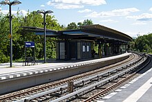
Berlin Priesterweg train station
| Berlin Priesterweg | |
|---|---|
|
Reception building
|
|
| Data | |
| Location in the network | Separation station |
| Design | Through station |
| Platform tracks | 4th |
| abbreviation | BPRS |
| IBNR | 8089034 |
| Price range | 4th |
| opening | October 7, 1928 |
| Profile on Bahnhof.de | Priest path |
| Architectural data | |
| Architectural style | expressionism |
| architect | Günther Liège |
| location | |
| City / municipality | Berlin |
| Place / district | Schöneberg |
| country | Berlin |
| Country | Germany |
| Coordinates | 52 ° 27 '36 " N , 13 ° 21' 23" E |
| Height ( SO ) | 50 m |
| Railway lines | |
| Railway stations in Berlin | |
The Priesterweg station is a S-Bahn station in the Schöneberg district of Berlin in the Tempelhof-Schöneberg district .
location
The stop is located in the district of Schoeneberg in Tempelhof-Schöneberg . Berlin city center is around eight kilometers to the northeast as the crow flies . It borders on the Priesterweg and the Prellerweg . To the east of the train station is the Südgelände Nature Park . To the southwest lies the Insulaner , a former mountain of rubble, on which the Wilhelm Foerster Observatory is located. The Southern Cross train station is located 1.8 kilometers to the north, the Attila Street Station 1.3 km and the train station south end 1.4 kilometers south. The station is located in the Berlin B tariff area of the Berlin-Brandenburg transport association .
history
The station opened on October 7, 1928. There were initially two central platforms . The electrification took place on July 2, 1929. Until that time, there were only electrical test operation with 550 V . Since May 15, 1939, the station has only been served by exclusively electric S-Bahn trains. A second exit was created and the entire station was modernized. During the Second World War , with the beginning of the Battle of Berlin, train traffic was stopped in mid-April 1945.
On June 8, 1945, the station was reopened for trains hauled by steam locomotives. From August 16, electrical operation was possible again.
With the takeover of the S-Bahn in West Berlin by the Berliner Verkehrsbetriebe (BVG) on January 9, 1984, the train service to Lichterfelde was stopped. The trains only ran on the outer tracks. In May 1990, platform A was taken out of service and the trains only ran on platform B. Platform A was demolished, completely rebuilt a little further south and reopened on June 29, 1992. Then platform B was also rebuilt. The old entrance and the station building remained, but were now at the northern end of the platform. On August 3, 1993, a new south access to platform A was built. The newly built platform B finally went into operation on December 6, 1993. Since then, the station has been partially covered. A new south entrance for platform B was also built in January 1995.
Since mid-2016, train handling has been carried out by the driver using the driver's cab monitor (ZAT-FM).
In September 2017, the Pr signal box building , which was located at the northern end of the western platform, was demolished.
Connection
Rail transport
The S-Bahn station is served by lines S2, S25 and S26 of the Berlin S-Bahn .
Bus transport
You can change to the following bus routes operated by the Berliner Verkehrsbetriebe :
| line | course |
|---|---|
| M76 | S Lichtenrade - U Walther Schreiber Platz |
| X76 | Lichtenrade, Nahariyastraße - U Walther Schreiber Platz |
| 170 | Baumschulenstrasse / Ferry - S + U Rathaus Steglitz |
| 246 | S + U Hermannstrasse - U Friedrich-Wilhelm-Platz |
literature
- Jürgen Meyer-Kronthaler, Wolfgang Kramer: Berlin's S-Bahn stations. Three quarters of a century . Be.bra, Berlin 1998, ISBN 3-930863-25-1 , p. 235-236 .
Web links
- Entry in the Berlin State Monument List
- Priesterweg station on stadtschnellbahn-berlin.de
Individual evidence
- ↑ Station price list 2020. In: Deutsche Bahn. Deutsche Bahn, January 1, 2020, accessed on July 11, 2020 .
- ↑ News in brief - S-Bahn . In: Berliner Verkehrsblätter . No. 8 , 2016, p. 160 .
- ↑ News in brief - S-Bahn . In: Berliner Verkehrsblätter . No. 11 , 2017, p. 231 .

